A closer look at Lowrance's HDS Gen2 Touch

... written for Panbo by Kees Verruijt and posted on May 13, 2013
hds12_via_go_free.png

Today is an excellent time to look in more depth at the Lowrance HDS Gen2 Touch, a slightly awkward name for six products that form the "top end" of the Lowrance multifunction display range. The reason is the recent release of the 2.0 software version that brings GoFree functionality -- as seen above -- and much more to both the Lowrance Gen2 and Gen2 Touch range. Last year I upgraded my HDS Gen1 to a HDS2T and in this entry I will compare the HDS2T to other Navico options, give you the reasons why I like it and of course discuss the new features in the 2.0 software.

HDS2T and its family members

As regular Panbo readers are aware the Lowrance HDS series shares a very high commonality with the other Navico chart plotters -- the Simrad NSS, NSE and NSO and B&G Zeus and Zeus Touch (ZT) systems. All of them use a common operating system named Navico Operating System (NOS), based on GNU/Linux, Qt and the NOS application. As Ben reported in March, the range subdivides into three target markets, with Lowrance focussing on fishing, Simrad on sport fishing and cruising and B&G on sailing.

In the early days of NOS the devices all ran on different hardware. The NSE/NSO/Zeus class is based on an x86 VIA processor, whereas the HDS Gen 1 ran on an low power Freescale i.MX ARM processor. The NSE is quicker, but uses a lot more power. Nowadays the newer displays (NSS, HDS2, Zeus T) all run on a Freescale i.MX51 ARM processor which still hasn't got the CPU power of the VIA C7 but also uses significantly less power. On digging into my HDS2T I found it runs a single core processor at 800 MHz, has 512 MB RAM and a 1 GB flash memory. To put that in perspective, it's 1/8th the CPU power, 1/4th the RAM and 1/64th of the flash memory of my Android phone.

Still, the touch class systems have quick enough redraw rates and enough memory to process even complicated chart areas. The Freescale processor also contains hardware support for video compression, which makes GoFree remote Viewer/Controller apps are possible over the restricted bandwidth that WiFi offers.

If you look carefully you will find that 90% of the functionality in the range is shared, like the generic chart plotting, sonar, radar, Sirius weather, SonicHub audio control and maybe even the CZone digital switching which Ben has recently begun testing (CZone is not mentioned anywhere by Lowrance, but it appears in the HDS2T 2.0 advanced settings menu). The differences between the different NOS products (that I am remembering now) are:

  • HDS can have more fishing hardware (Broadband sonar and/or StructureScan) built in. Simrad and B&G need extra black box hardware to offer the same functionality (the exception being the smaller NSS/ZT displays, which do have an internal Broadband Sonar module).
  • Simrad and B&G have a (Simrad) autopilot control feature.
  • B&G offers specific sailing calculations and displays, as discussed here on Panbo.
  • HDS can't control multiple SonicHub zones at different volume levels.
  • HDS has a different look & feel compared to Simrad and B&G.
  • HDS Gen2 Touch has a wide screen instead of 4x3.
  • Some broadband radar features, like 4G's independent dual ranges, are only supported on the x86 class products (NSE, NSO, Zeus).
  • HDS may have fewer CZone features, or at least it is de-emphasized in the documentation and website.

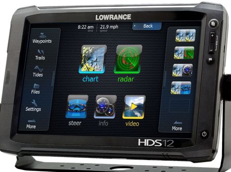
A HDS Gen2 has upgraded internal components compared to Gen1, so it is faster and has more RAM. Other than losing the round control ring which wasn't as useful as was claimed there is no real difference in external hardware. It looks as if the Gen1 is at EOL (end of life) and won't receive any major software upgrades beyond the current 4.1 software version. The Gen2T models have basically the same hardware as the Gen2 but have a wide, touch enabled screen, can have the StructureScan module built in and a 2nd Ethernet port and video input on the 9" and 12" models (like the one seen below).

Lowrance_HDS_Touch_w_2.0_software.jpg

Why I like the HDS 2 Touch

For me the important difference between the Lowrance and the Simrad/B&G is the different look and feel of the UI. The extra screen width provides for more pixels in the 7" and 12" versions (but not the 8/9" size) horizontally, of which good use is made by a soft menu on the right side.

The extra width of the wide screen allows the HDS2T to show a soft menu on the side, which in most cases infringes little on the display. It can easily be swiped away to offer a full screen view. In fact this main menu is very well executed, and usually contains exactly what you need, with the other menu items easily accessed by a swipe down on the menu bar.

I also like the HDS data overlay better than that of the Simrad & B&G units. On the Simrad version you can have a single row of data values at the top of the screen. If you need more you can have two alternating rows with one displayed at a time. This I found very distracting at night when standing watches in the wee hours. Also, it takes away valuable screen space. Also, it took me 4 watches before I found how to modify the databoxes (without a manual.) The HDS method of floating data boxes that can be adjusted in size and location is, in my opinion, easier on the eye, doesn't hide as much of the chart and is much more flexible.

Touch control

In general, the touch control on the HDS feels very polished and robust. I was worried that it might be executed the same way as a normal tablet, but it seems the engineers have tuned the minimal duration and location of a touch such that accidental operation is minimized. Over the last two months I found that I hardly had a case where the plotter did not do what I want. One helpful feature of the touch interface is what is called "Cursor Assist" mode. If you put your finger on the screen it is hard to see exactly what you are "touching". If you keep your finger on the screen a "looking glass" appears on the screen immediately above your finger. This cursor stays immediately above your finger, allowing you to place the cursor at exactly the right spot.

One thing which I did not really realize would make a difference is that it is now a lot easier to control the SonicHub audio interface. On my HDS 8 I had to long-select twice to move the selected window to SonicHub before I could adjust the audio volume using up/down. This easily took 6 seconds. Now it is a quick tap on the SonicHub bar and presto the + - buttons are the volume controller.

Bigger is not better in all aspects

hds8_lamanche.png

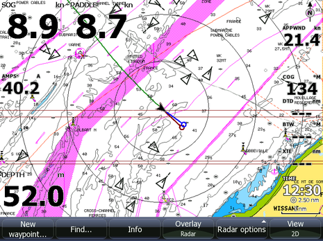
A bigger screen is easier to read, and can show more detail. Just compare the 800x600 pixel 8" HDS Gen1 screenshot above with the 12" HDS2T screen below showing the same chart area but with 1280x800 pixels (click on both files to get the full size and compared them side-by-side).

hds12_lamanche.png

However a big screen also has its disadvantages. The simplest is that it might just not fit the mounting location that you have in mind. Another that may play a role for sailors is the power consumption. Even though the latest plotters, in general, use much less power than their predecessors, keep in mind that a big screen still uses more electricity. My HDS 8 used 0.4 / 0.7 / 1.0 A at low (night), next-to-max and max brightness. In comparison I measured my new 12" HDS2T and it uses 0.7 / 1.2 / 2.0 A in the same circumstances. A little bit (about a quarter of an amp) can be attributed to the faster and extended hardware, but still it is quite a difference. Note that the difference between the highest brightness step and just one level down is a huge reduction in power consumption of 40%. I imagine this will be true of any LED backlight, so just keep it (at least) one level lower than max if you are trying to make your batteries last.

GoFree: remote display & NMEA 0183 streaming

As the main reason for me getting the HDS2T, I was hoping this would work well. Luckily, it does! Still, there are some improvements that could still be made. You can download the free Simrad, B&G or Lowrance GoFree app from the Apple store. It does not seem that there are any functional differences between them -- I get exactly the same controls and features in the Simrad app as in the Lowrance app.

I don't have a Navico Wifi-1 module but my own Linux based router/server which uses simple Linux bridging and acts as a DHCP server, so all devices get an IP address. I'm happy to report that the HDS2T had no problems in working with the assigned IP address, and the GoFree app immediately found the HDS2T and connected flawlessly. I guess that Navico sells the Wifi-1 as a solution for a plug-and-play solution, I've heard that they don't mind when the system is included in a larger existing WiFi system. This is great as it means you don't have to switch between multiple onboard WiFi systems.

Once connected you can control all features of the chartplotter, and press all buttons. The plotter does become a bit more sluggish, so it's definitely not a 'free' service in terms of processing power. This is most apparent when scrolling or using displays with multiple areas.

One issue I did find is that if you have accidentally started the GoFree app whilst still connected to the wrong network it will keep on searching that network even if you have since switched to the correct one. Stop the app completely by opening the multi-task bar (double click on Home) then click-and-hold until you see a red "delete" button attached to all recent apps, click on GoFree. After this you can start it again and it will find your plotter immediately.

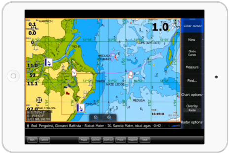
The other issue is that there can be some improvement of the fidelity of the display. The HDS display in the GoFree app is a little hazy, as if too much compression has been used. Click on the top image of this entry to see what I mean. As my retina iPad has exactly double the resolution of the HDS, a cleaner picture is possible. What would be nice to see in the GoFree app is the option to tune how much compression is used, and be able to choose a pixel-perfect (but possibly slower) display.

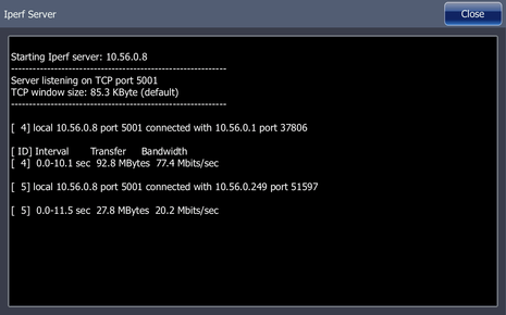
In the menu I noticed that the 2.0 software comes with the ability to show the HDS IP address, what I think may be the capability to control Wifi-1 access points, and network testing tools. It even has an iperf server so you can test the bandwidth of the network connection. Using the iperf tool on my laptop and Linux server I found that the wired capacity was 77 Mbit/s and my wireless still managed 20 MBit/s, only 1 MBit/s slower than the wireless bandwidth directly to the router.

hds2t_iperf.png

If you know your display's IP address you can use a GoFree enabled plotter as an Ethernet TCP server for NMEA 0183 data. Go to Network > NMEA0183 > Ethernet for information on how to connect your app. My HDS is only connected to NMEA 2000 sensors, but it generates a full NMEA 0183 stream with all available data (sensors, GPS, AIS). It even includes a non-standard sentence so that air temperature, heel, trim, barometer and rudder data can be transferred. Very well done!

Navionics chart improvements

A whole ream of improvements has been made to the chart representation of Navionics charts. They may not be world firsts as I think I have seen every one of these features in other chart plotters, but it is nice to see Navico/Navionics play catch up here.

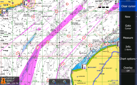
  • The ability to hide rocks deeper than a particular depth. This declutters the chart in areas with many (charted) rocks like Norway.
  • The ability to highlight a particular interesting water depth between a certain lower and upper bound.
  • The ability to make very shallow water stand out using red dots.
  • New on-chart display of tidal heights and streams.
  • The ability to use a larger icons and fonts for chart data (Easy Read).

Whether and how useful these features are going to be will depend on your area and how detailed the charts are. Our home waters are so shallow that the "warn for shallow water" feature is useless, and we don't have any rocks, but we do care about currents and tidal heights so I do appreciate these feature, shown to great effect in the screenshots above.

Other features in the 2.0 software release

I will just mention the rest of the 2.0 software features very briefly.

  • Support for Lowrance Point-1 GPS (configuration.)
  • 5 Hz update rate of the internal GPS.
  • Support for Insight Genesis (for creating your own hi-res depth charts) and StructureMap HD.
  • Chart sharing across the network (long overdue!)
  • Simultaneous display of two different chart providers.
  • PDF viewer for manuals and such.

Here's Lowrance's HDS2T 2.0 download page with detailed release notes.

For the HDS Gen 2 this is an even bigger release (download and notes here) as it brings it fully back to par with the Gen 2 Touch:

  • Similar icons and button use
  • Similar custom split screens
  • Export user data based on region
  • StructureScan Auto Contrast
  • More tanks and engines can be shown in the instrument display
  • Support for the standard PGNs for AIS class B static information

Comments

Thanks, Kees! Your ability to understand the hardware and software behind the Navico scene is much appreciated.

I for one am very curious if you have your HDS2T networked with radar, sonar, and/or your older HDS while also doing GoFree through your own router? If so, are you using special router settings?

I did get WiFi1 running well on Gizmo but it took updates to NSE, 4G radar, and the radar interface to make it work. It seems that Navico has had to change the way it does Ethernet and a reader this morning (DJ) reports that a Gen1 HDS will not work on a WiFi1 network according to Navico.

I hope you're ready to answer lots of questions about this ;-)

Posted by: Ben E at May 13, 2013 8:13 AM | Reply

I did find where Lowrance warns that "GoFree Wireless Technology will not function when a Gen1 display is on the network":

http://www.lowrance.com/en-US/Products/Wireless/GoFree-WIFI-1-Module-en-us.aspx

On the other hand, some WiFi1 pages now include Web Interface and Advanced Settings instructions that seem promising. Hopefully Kees or someone will decipher ;-)

http://www.simrad-yachting.com/en-GB/Products/NSS-Touchscreen-Navigation/WIFI-1-module-en-gb.aspx

Also, I just realized that the Lowrance/Simrad/B&G viewer/controller app is now available for Android, which I hope to try later today.

https://play.google.com/store/apps/details?id=com.navico.lowrancegofree

Posted by: Ben E at May 13, 2013 9:57 AM | Reply

Yes, I can imagine they had to change the networking in order to play nice with more complicated networks than just radar, sonar and plotters.

Did you try GoFree before the updates were installed, and was it really broken, or did you upgrade before you started using the WIFi-1? Also, having to put new software in the radar interface means it is not as simple as just some connectors and RFI filters, apparently it contains some real software!

As you can read in the GoFree Advanced Setup documentation Navico now officially "tolerates" 3rd party routers. I'm not sure what they changed in the newer software releases to make this and Wifi-1 possible, nor why they had to. The only thing that makes is that some devices would not listen to DHCP servers, causing them to be part of different IP networks. Or maybe they just got confused and locked up?

I have upgraded from HDS Gen 1 + BR24 to HDS2T + 4G so I will do some more network sniffing and compare it to my old logs. However, I'm not in the position to put a HDS1 on the same network and see if that messes up things and why. Its not the main radar data traffic, that is on the same multicast address and port.

What I've got on board is a wired network using a normal "unmanaged" ethernet switch (which does some learning, but transmits all multicast and broadcast packets on all ports) and a Linux system (for the curious: an Alix 2d13 running Debian 7) that uses the default "bridged" Wifi/LAN configuration possible under Linux. This is basically equivalent in terms of routing as most standard routers running Linux, so your typical Netgear/Cisco/... should work as well. The router hands out DHCP IP addresses.

Note that the GoFree capable plotters use Bonjour, the protocol that Apple pushed for ZeroConf setup, to advertise their capabilities. The iOS GoFree app can listen for these advertisements. That's how your plotters show up in the screen without a search. I am pretty sure that HDS Gen1 did not use Bonjour at all, it just listened for multicast and broadcast packets.

PS:

Another difference between the various NOS devices that I forgot to list is the difference in built-in charts. I'm not 100% on this but I think that NSE/NSO/Zeus have big Navionics Gold chart areas and Silver for the rest of the world, NSS has Insight USA in the US and (I think) some level of Navionics Gold/Silver in ROW?, and HDS comes with Insight USA or some regional choice. Mine (in the Netherlands) came with an empty SD card that I could plug in and download a Navionics Gold chart for (at cost.)

Posted by: Kees at May 13, 2013 10:22 AM | Reply

I have the NSS8 plugged into one WiFi1 port and the NSE12/4G/LSS all coming into its other port, and that may have complicated things. GoFree worked with NSS right away but the radar and StructureScan to be seen by both MFDs took all the updating.

At any rate, I'm having the same experience you are where I have no NMEA 0183 sensors but GoFree is delivering tons of "0183" data to apps like iNavX, Mid, and iRegatta Pro. GPS, Depth, Wind, AIS, etc all there and pretty fast. Apparently the MFDs are translating N2K data into 0183 messages, which seems quite generous.

Posted by: Ben E in reply to Kees at May 13, 2013 11:05 AM | Reply

I recently installed on my [new to me] 1992 Carver28 Command Bridge:
(1) the Lowrance HDS-12 Gen2 Touch;
(2) the Lowrance fluxgate rate compass;
(3) the Lowrance 3G broadband radar;
(4) a B744v thru-hull transducer;
(5) the Lowrance Link-8 DSC VHF/AIS radio; and
(6) the GoFree WiFi-1.

The GoFree enables use of my old iPad-1 as an MDF mirror/controller at my secondary conning station in the main cabin [for bad weather only]. It's also useful for planning routes and waypoints in the cabin when not underway.

With the arrival this past weekend of the Lowrance 2.0 system update, I finally got it all working together. There was however one minor glitch. After installing the HDS-12 Gen2 Touch update, a message appeared at the bottom of the chart screen partially covering up the "+/-" zoom soft keys telling me to update the 3G radar operating system. This was puzzling since I only bought the 3G radar in January 2013 and the Lowrance Update webpage shows that the latest 3G radar update was in November 2011. However, I went ahead and downloaded/updated the radar as requested. But then that radar update message did not go away . . . even though the MFD thanked me for making the radar system upgrade. So I shut her all down, turned off the power to the whole system, and launched everything again. Finally it seems to be functioning properly . . . with no warning messages.

Kees, thanks for your great article. Most of the techie stuff you explain is — at this point — a bit over my head. I just know that now that it's all up & running, I love it. I'm in Seattle and mostly cruise Puget Sound and the San Juan & Gulf Islands. I have installed the Navionics Gold chip for the Northwest and Canadian west coast up to south Alaska. I really like the improvements this 2.0 system upgrade provides to my Navionics charts.

I understand that the Lowrance system is great for fishing. Since my Carver is a twin screw inboard, I had to install a thru-hull transducer . . . but I saved the skimmer-type transducer [came in the box with the MFD Touch] which facilitates structure scan & side scan sonar. I plan on installing the skimmer on the transom of my 25' 1976 Bayliner Saratoga Express which I still use for fishing. I figure on getting double duty out of the HDS-12 Gen2 Touch MFD by mounting it on my Bayliner when I go fishing/crabbing. I'll just have to get another fluxgate rate compass and Link-8 radio to go on that fishing boat . . . and might even get another 3G radar.

When I purchased my Carver last year, it had no electronics other than an old VHF. So I wanted only the latest stuff. . . but at a reasonable price. I needed the low emission broadband radar mounted just forward of the bridge since the boat lacks a mast or an arch. The 3G still gives 360 reception. I purchased this new Lowrance system [with Seattle Boat Show discounts] and it came in at less than $5,800.00 [not counting installation]. I'm very pleased.

Jim

Posted by: Jim Klauser at May 13, 2013 6:32 PM | Reply

Too bad the HDS Gen1 is EOL. It's a great unit. I was going to add a Lowrance Point-1 GPS/compass and AIS this summer, but since they no longer update the HDS1 software, I can't easily calibrate the Point-1 and the the unit doesn't support the proper class B AIS PGNs.
If they think I can drop $1500 every other year for an upgrade, they are mistaken. There is no incentive to upgrade because as soon as I do, they'll just come out with Gen3 and the cycle starts all over again. I don't think that a 3 year life cycle is sufficient.
Disappointing..

Posted by: Andreas at May 13, 2013 8:33 PM | Reply

Kees. Very well written, Thanks!

In regards to the screen captures that follow Bigger is not always Better, the triangles in the first shot are ships while the five sided red boxes in the second shot are something else, current?

Posted by: Dan Corcoran (b393capt) at May 13, 2013 10:42 PM | Reply

Kees,

Great article. I'm impressed with the openness of the HDS Gen 2. With the HDS outputting NEMA 0183 over TCP I'm not urge I would want the mirrored display. Why not use polar or another tool to use the data from the network? "it generates a full NMEA 0183 stream with all available data".

The support (or acceptance) of an existing wifi network is outstanding. Now if it could overlay weather info from the WiFi network ....

Posted by: Pat McQueen at May 13, 2013 11:33 PM | Reply

Andreas,

Your Gen1 is exactly the same as it was last year, so why grumble? Three years of updates for functional upgrades is about par I would say.

If you want AIS infor including class B static data on your Gen1 your options are many:
- Transfer the AIS data via NMEA 0183
- Get a Navico AIS and transfer it via NMEA 2000

Likewise for the Point-1 -- it will work but your calibration is a little more difficult.

Sorry, I just don't see how manufacturers have to keep supplying free software updates to make their products offer 100% of the functionality of new hardware. They only make money on the initial sale.

Posted by: Kees in reply to Andreas at May 14, 2013 3:19 AM | Reply

Ben, Jim,

The way your and Jim's systems worked before/after the upgrade all points towards the fact that the older firmware releases had different ideas of what IP network range (you know, the 192.168.x.x stuff) would be in force in different scenarios, and the firmware updates ensure that everything works nice in an environment with a DHCP server present.

Getting it right in both small networks (just radar and MFD or sonar and MFD) as well as more complicated bigger installations with DHCP servers and multiple networks is not simple. Just read the Furuno manual for NN3D where they discuss integration of Axis webcams. Everything must have a particular hardwired IP range in their solution. That is OK for a professional installation where a dedicated IT guy does the install, but is not suited to the typical DIY install on yachts and small boats.

So, kudos to Navico for making it work on medium sized networks, in the way that we want.

Posted by: Kees in reply to Ben E at May 14, 2013 3:32 AM | Reply

Hi Dan,

Yes, the black triangles are AIS targets. The five sided red boxes in the Gen 2 screenshot are indeed showing direction and strength of currents. Those are new with the 2.0 software release. You can see them in the top GoFree iPad picture as well. That one also shows how tides are now shown in-chart with a tidal height and direction (rising/falling).

I had this 10 years ago in Nobeltec, but its still a really great addition!

Posted by: Kees in reply to Dan Corcoran (b393capt) at May 14, 2013 3:39 AM | Reply

Hi Kees,
You are correct, the there are technical alternatives to get AIS working on HDS-1.
I could get a NAVICO AIS transceiver. Unfortunately they are about $300 more expensive than for example the em-trak B100. That seems a high price to pay to accommodate some proprietary PGNs. I'd prefer a software update to incorporate the standard PGNs.
I could use 0183, but that would mean soldering custom cables together. I specifically built my boat around NMEA2000 so I wouldn't have to do that.
I think I'll wait a year an upgrade to the Gen2 touch. By that time, the feature set will be mature. Just in time for the next version to come out :-)

Posted by: Anonymous in reply to Kees at May 14, 2013 11:32 AM | Reply

I updated my touch, connected up an old wrtg54g Linksys with a custom built cable from a cut in half lowrance Ethernet cable, I could ping, but video was very choppy, not usable. IGMP was flooding the network from the sidescan sonar box. I am running the first generation side scan units. I ditched the wrtg Linksys because it cannot block the igmp packets, and threw a netgear router in there, and it works great! It is so much faster editing waypoints on the ipad, changing settings, and having a second virtual HDStouch unit basically anywhere I want on the boat. Lowrance nailed this one. It was worth the 5 month wait!

Posted by: Charles Green at May 14, 2013 1:12 PM | Reply

My (Dutch) distributor just informed my that they now stock all NOS devices except NSO in two versions: without built-in charts or with Navionics Silver on (micro)SD. Navionics Gold or CMap can be ordered separately.

As was announced in the HDS release GoFree also works with Gen2 (Non-touch) but in a read-only version. It is likely that this will also be rolled out to NSE / NSO / Zeus, but there are no dates yet.

Posted by: Kees at May 14, 2013 3:33 PM | Reply

It seems like Navico is becoming chart agnostic, something like Furuno. The Insight store is getting quite interesting with C-Map and Insight cartography already for sale and download:

https://insightstore.navico.com/

Posted by: Ben E at May 14, 2013 5:33 PM | Reply

Hi Kees,

Great news about the NMEA0183 sentences being streamed over wifi. I hope to use my existing router onboard (one master network).

Question I have is this: I see from comments here that iPad apps can see that streamed data. But will a PC chartplotter program see them too? Something like OpenCPN or Fugawi Marine 5. Or do they require a specific nominated port to listen for the data stream?

I intend to run my PC (with its own GPS) as a back up nav con.

Posted by: Matt at May 14, 2013 11:33 PM | Reply

Hi Matt, of course you can use OpenCPN or anything else that accepts NMEA 0183 streams over Ethernet. The only requirement is that it is able to contact a TCP server at a particular port (10110).

Note that this won't exactly make for a backup: If the plotter dies, it will most likely not send out this information :-) but it is great as a source of information for a 2nd nav station, either PC or tablet based.


Posted by: Kees at May 15, 2013 4:10 AM | Reply

A PC chartplotter with support for network NMEA data will work. I tested this with my Wifi-1 and WinGPS.

Put the ip-address in and the port number and the chartplotter will get the data.

Posted by: Erik at May 15, 2013 4:11 AM | Reply

Ah yes, I realise I will lose the stream if the chartplotter dies. Hence my spare USB GPS for the laptop :D

But yeah, a great 2nd Nav station solution, as well as the iPad control.

Posted by: Matt in reply to Kees at May 15, 2013 5:04 AM | Reply

GoFree flexibility: I was just running iNavX and iRegatta Pro with streaming AIS, wind, depth, heading, etc. on two iPads while NSS-8 was in Standby mode.

Posted by: Ben E at May 15, 2013 11:50 AM | Reply

Your Gen1 is exactly the same as it was last year, so why grumble?

The AIS bug was there last year, we grumbled then too.

Three years of updates for functional upgrades is about par I would say.

The Lowrance "5-Year Advantage" promises comprehensive support for five years. It's not clear what that means in practice; it may be limited to units which are completely dead. I doubt failure to properly do AIS counts.

If you want AIS info including class B static data on your Gen1 your options are many

Or buy a new chartplotter, possibly by Garmin or Raymarine...

Sorry, I just don't see how manufacturers have to keep supplying free software updates to make their products offer 100% of the functionality of new hardware. They only make money on the initial sale.

Manufacturers are not required to do this and we do not expect them to. It's not just a matter of initial sales; it is a matter of building brand loyalty in your customers. Keeping your customers happy pays and doesn't cost that much. A very simple AIS bug fix on the HDS Gen-1 would make a big difference to the few who are affected; Navico already knows how to do it.

I have lots of old software for which I still get updates to keep it functional and safe. Companies which take care of me will get my return business.

Posted by: norse in reply to Kees at May 15, 2013 1:28 PM | Reply

Navico NAIS 400 and em trak B100 are using the same AIS board from SRT so I would not be surprised if also B100 can decode the Navico specific PGN's. I have B100, will try to remember to bring out a first generation HDS-8m I have laying around to check.

Posted by: abbor in reply to Anonymous at May 15, 2013 2:19 PM | Reply

Why should Navico spend engineering resources on updating the AIS part of first generation HDS? If a customer is buying NAIS 400 or Point-8/RS35 VHF with built in AIS receiver, it will play nicely together. By doing this update they actually risk getting negative payback by selling less AIS equipment.

Posted by: abbor in reply to norse at May 15, 2013 2:32 PM | Reply

Why should Navico spend engineering resources on updating the AIS part of first generation HDS?

If you don't like my "do the right thing" and economic reasons above, here is another.

Even though they've been making cars for a hundred years, they still add new models every year with new features. Nobody expects car manufacturers to quickly drop support of previous years' models. And even after OEM parts are no longer available there are still after-market part suppliers.

If Navico drops support, there is nowhere else to get support. Therefore, before you buy any marine electronics, one of your first questions should be "how much do I trust this manufacturer?". Solid reputation or fly-by-night or about-to-go-out-of-business? That is why a marine manufacturer must give reasonable support for older products, even if they would rather sell the latest greatest.

As for cost, Navico has already spent the engineering dollars to solve the AIS problem. They might have to spend a few more to test it in HDS Gen-1 units, but that expense is a drop in the bucket compared to what marketing costs.

I'll fix their bug for free if they give me access to the code :-)

Posted by: norse in reply to abbor at May 16, 2013 1:08 PM | Reply

Very timely article. I'm starting a e-refit and have been looking at all the majors. I keep coming back to the value of the Lowrance, and think the industrial design (ID) aesthetic is the best, IMHO. I very much appreciate the technical detail. Thanks!

Posted by: Mic at May 17, 2013 10:24 AM | Reply

Hello,
Any of you guys running lowrance hds gen2 10 with 4g radar?
I upgraded the software and now the unit doesn't recognize the scanner and gives a error message " grade 4G software 2856-A" I am getting no where with tech support and having to speak to multiple people and Is frustrating beyond belief. I have almost 7500$ in new lowrance equipment on this boat and very unhappy as we have worked so hard to get boat ready for our vacation coming up at the end of this week . I even had one rep ask if I could borrow a unit just to test my equipment that was working prior to software update, the only reason I upgraded was to install the gofree wifi... I have done everything I have been asked to do by all the techs and unless I want to do without my unit for 20 days min I have to live with it or buy another unit... I would love to install the old software back into my unit but that was off the table with the tech support..
Making me wish I never heard the name lowrance.....

Kevin H

Posted by: Kevin Honeycutt at May 19, 2013 6:40 PM | Reply

Hi Kevin, I had to update my boat's 4G radar to version 4.1.57 in order for a Simrad NSS8 and NSE12 to still recognize the scanner with a WiFi1 in the network. It seems odd that this update seems to be available at the Simrad site:

http://www.simrad-yachting.com/en-US/Support/Downloads/4G-Radar-Software/

but not at the Lowrance site:

http://www.lowrance.com/en-US/Products/Radar/broadband4g-radar-en-us.aspx

I can not guarantee it, but I suspect that the Simrad 4G update will work on a Lowrance 4G.

Alternatively, I found that I could get the radar back simply by rerouting the Ethernet cables so that the WiFi1 was not involved.

Kees may also have advice as I think he has an HDS2T working with 4G, though he's not using WiFi1.

Posted by: Ben E in reply to Kevin Honeycutt at May 19, 2013 7:41 PM | Reply

Kevin,

I understand your frustration. My comment is the 4th one to Kees' article set forth above [made on 5/13/13] where I list my system's Lowrance components . . . including the HDS12 Gen2T, the 3G radar, and GoFree-1 wifi.

The warning message I described which says . . . "Broadband 3G-2760: Please upgrade the radar software" . . . seemed to go away after I reloaded the old Lowrance 3G radar operating software [from 2011] . But just yesterday that same warning message has returned to the bottom of my MFD screen partially covering the "+/-" zoom in/out soft keys. Otherwise, the whole system — including the MFD Touch, the 3G radar, the sonar, and the wifi [enabling my iPad-1] — seems to be functioning OK.

I'll be calling customer service myself first thing on Monday to ask about this annoying on-screen message. You might try shutting down all power and rebooting. Let us know what happens. Good luck.

Jim Klauser, Seattle, WA

Posted by: Kim Klauser in reply to Kevin Honeycutt at May 20, 2013 12:45 AM | Reply

Kevin,

My 4G came with the upgraded software version, so I had no issues. Also not using WiFi1 may mean a slightly different network setup. Thus I did not notice that this software update isn't available from the lowrance.com website.

Ben's advise appears sound, but to be safe I double checked with a Navico support manager and you can indeed upgrade the radar using the Simrad software.

2856-A is the serial number of your radome, to indicate which radar should be upgraded in a multi-radar setup.

To be clear, whose tech support are you talking about in which country? It seems suspect they don't know that the radar is to be upgraded (as the screen says?)

Posted by: Kees at May 20, 2013 3:59 AM | Reply

Thanks for the reply's, I am talking the the lowrance tech guys in Oklahoma USA.
I'm not sure what software The 4G has in it I'm going to try to figure that out this AM however it's not even recognized in the device list anymore since I installed the gofree wifi and 2.0 update.
Kees, thanks you for making contact with support for me I hope I can use the software update from them and fix my issue? I can't understand after days of being on the phone with Lowrance why they wouldn't give me that info. I'm so tired of dealing with them.
I'm going to unhook the gofree and see if the MFD will recognize the scanner again first this morning just to see if that also works for me also I need to find out what software is in the scanner but since it is not recognized I'm not sure where to find that.
Once again thanks for any and all help.

Kevin

Posted by: Anonymous at May 20, 2013 7:38 AM | Reply

Kevin, to be extra clear I was getting the same "please update radar" that Jim Klauser describes, only at the bottom of an NSS8 screen. And it took at least one total reboot to get everything working right. But after that I didn't see any problems during a couple weeks underway almost every day, and it doesn't matter what order I turn things on.

Let's also note that the prime feature of the 4.1.57 4G update is GoFree WiFi-1 compatibility and at least some of the text is not brand specific:

"Thanks to this free software upgrade, users can now enjoy wireless control of a number of features within their Broadband 4G Radar, when used alongside the WIFI-1™ module and a compatible multifunction display."

And, guess what, Simrad also offers a 3.0.38 GoFree update for 3G radars which I don't see listed at Lowrance:

http://www.simrad-yachting.com/en-US/Support/Downloads/3G-Radar-Software-December-2012/

It seems quite possible that Lowrance missed the radar update boat somehow -- in their defense, GoFree support has just come out -- but I'll bet they fix that (and maybe a little credit is due to Panbo ;-)

Posted by: Ben E at May 20, 2013 10:30 AM | Reply

Thanks Ben!
I downloaded the new update from simrad on a SD card and followed the upgrade instructions from lowrance website but the lowrance won't recognize it although it does show up in the file Que when I go to menu I don't have the update or upgrade software option key.
I'm sure they will come with a fix and I know that is what it is due to the fact I removed the gofree and everything works as designed..
I'm sure there is a way to download that software update if I can ever get ahold of tech support this morning so far no luck..

Kevin

Posted by: Kevin Honeycutt in reply to Ben E at May 20, 2013 10:45 AM | Reply

Hi Kevin, I looked at the Simrad instructions and remembered that there are two update files, "radar.riw" for NSO/NSE/NSS/Zues and "radar.ri2" for GB40/NX4x. Was it the .riw file you tried?

Posted by: Ben E in reply to Kevin Honeycutt at May 20, 2013 10:56 AM | Reply

One other idea, probably irrelevant as most Lowrance/Radar setups don't use the RI10 Radar Interface Box. But if you do have one that's somewhat old, it too needs an update:

http://www.simrad-yachting.com/en-US/Support/Downloads/RI10-New-Software-1-4-0-and-1-4-1/

Posted by: Ben E at May 20, 2013 10:59 AM | Reply

Ben,
It downloads both files in one zip and doesn't give the user the choice of choosing. The way I read the instructions from simrad the file is automatically choose?

Kevin

Posted by: Kevin Honeycutt in reply to Ben E at May 20, 2013 11:04 AM | Reply

Unzip the files, Kevin. The instructions aren't crystal clear but if you look at Step #7, you will see the MFD operator choosing the "radar.riw" file, not a xxxx.zip file. Right clicking the xxx.zip file on your PC should get you to an "extract" command or maybe you can click open the xxx.zip file and just drag the radar.riw file to your SD card. I think that you are close to success.

Posted by: Ben E in reply to Kevin Honeycutt at May 20, 2013 11:13 AM | Reply

Ben,
Your my hero!!! I'm a happy young man.... We have SUCCESS! The riw is the correct one and its all working like it should! I'm gonna call the lowrance tech back and tell them.
They need to get that up on there website ASAP so others are not stressed out like me lol. Man do I fell I sigh of relief THANK YOU!

Kevin

Posted by: Kevin Honeycutt at May 20, 2013 11:24 AM | Reply

My pleasure, Kevin! But you might tell Navico that Panbo offers not only amateur tech support but banner advertising that gets seen by the right folks like yourself ;-)

Posted by: Ben E in reply to Kevin Honeycutt at May 20, 2013 11:33 AM | Reply

Ben,
You can bet on it! They will know how I feel about panbo I can assure you that I'm waiting on call back now.

Posted by: Kevin Honeycutt in reply to Ben E at May 20, 2013 11:37 AM | Reply

Just some FYI, I just got off the phone with David from navico "lowrance" so they are looking into the fix that Ben helped me with, the only issue now is that the lowrance app will not automatically pick up on the gofree wifi . I have to manually enter the IP address listed under device menu then the app will connect to the display on the HDS 10 gen 2.
So maybe soon they will have a fix for that so it will work like it should. I know I was very frustrated and still would be if I didn't get it going with some major help from the blog, however I want to clarify that I do and would recommend the lowrance equipment to others and would buy it again its just I didn't feel like I have to devote the last 4 days into research to get my equipment up and running correctly due to a software issue that lowrance hasn't heard about yet when simrad already had a fix from 2012.
Thanks again to Panbo and you can bet the other blogs I belong too are going to know who takes there time to help others...

Kevin

Posted by: Kevin Honeycutt at May 20, 2013 1:57 PM | Reply

Kevin, what device are you using - iPad or Android?

Posted by: fixer01 in reply to Kevin Honeycutt at May 20, 2013 3:37 PM | Reply

I'm using ipad2 however just for kicks I load the app on my android phone as well.

Posted by: Kevin Honeycutt in reply to fixer01 at May 20, 2013 5:18 PM | Reply

Me again with more numpty questions ;)


Situation: not yet purchased HDSG2T, but boat is being hauled for anti-foul tomorrow and I have a DST-800 triducer available. Thinking to install it while the boat is out of the water.

This version of the DST-800 has a 5-pin plug, on the receipt called "device net" and looks like a regular N2k plug.

Q1 - I assume the DST800 will connect with my proposed N2K backbone and provide D/S/T info to the HDS? (I can see it as an option on the Simrad site for the NSS, but no mention at Lowrance).

Q2) Side scan, down scan, structure scan, Broadband sonar...getting confusing! In addition to the DST800, what else do I need to get the sonar and scan-stuff working on the HDS? Just a Lowrance LSS-2 HD Bronze Thru-Hull Transducer or do I need a broadband transducer for sonar as well?

Q3) related to Q2...according to Defender, Lowrance do a "Lowrance StructureScan HD Skimmer Sonar Imaging Transducer" - which is a transom mount thing. Would this do it all up/down/side scan and sonar? And suitable for a 33' sportfish? Obviously this is $400cheaper than the bronze one, but I am not sure if they are feature-comparable.

Cheers,
Matt

Posted by: Matt at May 21, 2013 10:31 AM | Reply

Matt,

A1) Yes, a DST-800 will provide speed/depth/temp.

A2) The DST-800 will provide a digital depth value, but not sonar. You need a separate transducer for sonar, and a 3rd transducer for structure scan.

A3) The StructureScan HD transducers only do StructureScan, not normal sonar.

What type of sonar you want is obviously up to you... possibly structure scan + depth from the DST is enough, but I don't know whether you can do enough fishing without the sonar.

Posted by: Kees in reply to Matt at May 21, 2013 11:15 AM | Reply

I can add a few details.

DownScan is part of StructureScan and is similarly better at looking at structure than fish. With StructureScan you will get a numerical depth overlaid on the SS screens and at least on my NSS it is also available as a value called "Structure Depth" that can be put in data bars. I also have DST100 on the network and that Depth can be shown on the NSS simultaneously if desired, which is useful in Gizmo's case as one transducer is well forward and the other aft.

The original transom-mount LSS transducer worked fine for me on a small outboard but I'd be hesitant to mount anywhere aft of propellers. StructureScan sees prop wash quite well, sometimes even long after the boat that made it is gone.

NMEA 2000 uses the DeviceNet standard for cables and connectors. The smaller connectors that we're all used to are also sometimes called Micro C.

Posted by: Ben E in reply to Matt at May 21, 2013 12:04 PM | Reply

It turns out that Lowrance 3G/4G radar software updates may have been online for a while, even if their respective product pages say "no software available":

http://www.lowrance.com/en-US/Software-Updates/Broadband-3G-Radar/

http://www.lowrance.com/en-US/Software-Updates/Broadband-4G-Radar/

So maybe I wasn't such a hero to send poor Kevin off to the Simrad site for the update ;-(

Posted by: Ben E at May 21, 2013 12:15 PM | Reply

Ben,
I couldn't find that, and lowrance technical support certainly don't know about that...
Lol :-)

Posted by: Anonymous in reply to Ben E at May 21, 2013 12:33 PM | Reply

Kees,
I agree with most of the points you made about back compatibility of Gen 1 plotters with newer and more feature rich lines (Gen 2 and Touch).
The way I understand the basics of networking of the consumer electronics, introduction of newer protocols should allow older products to function without impeding the operability of newly launched products. The fact that Navico warns that leaving Gen 1 networked with Gen 2 & Touch will cause Wi-Fi to not work is not something I take lightly. My office computer network runs Win 8, 7 and Vista workstations. If I chose to plug an XP computer, I can assure all users that our Wi-Fi will stay intact so our l-phones and Android devices can take advantage of the beauty of networking. I hope someone at Navico will get the point that forcing users to unplug old modules so the new modules can work properly goes agaist the good business and against building loyalty concepts. Otherwise, would Gen 3 product be worth investing in when it goes on sale in 2014?


DJ


Posted by: DJ in reply to Kees at May 21, 2013 11:06 PM | Reply

The radar updates are now up on the main software update page at lowrance.com, so availability of these updates is now not an issue anymore.

Posted by: Kees at May 22, 2013 1:03 PM | Reply

DJ,

I agree with you that adding new equipment should not mess up existing stuff, and I don't fully understand why this is. I don't have a WiFi-1, but I've been analyzing the network traffic that the broadband radars produce and there isn't that much of a difference between BR24 and 3G/4G after upgrade.

Hopefully some Panbot will try it out and see what happens if you run Gen1 with WiFi-1?

Posted by: Kees in reply to DJ at May 22, 2013 1:10 PM | Reply

Kees,

No difference when the lastest radar software was installed as well?

Posted by: Hendrik at May 22, 2013 3:44 PM | Reply

Hendrik,

Nope. All (main) radar outgoing traffic and control commands from the MFD remain multicast traffic, which doesn't care about what network IP address the sender is on.

What could be an issue is that without specific measures is that the radar might flood a wireless network, but I haven't researched the multicast RFCs yet and so I can't tell for sure. My Linux based router, by default, stops transmitting the bridged multicast traffic after a few minutes. It would be enough to overwhelm a 802.11b/g and maybe even n network. Mine is 802.11a (on 5 GHz) so it copes (just). Maybe the WiFi-1 does this differently in order to stop those first few minutes of traffic as well. Still, why this would prevent a Gen1 to work I don't know.

Another issue could be DHCP, but I've seen every Lowrance product I've owned behave well in the presence of a DHCP server -- they request an IP address and just apply the address given to them without any fuss -- so I don't think DHCP in itself is a problem.

Posted by: Kees in reply to Hendrik at May 22, 2013 3:55 PM | Reply

The GoFree Wifi-1 uses IGMP Snooping to prevent radar multicast data being transmitted over Wifi - see the document here:
http://www.simrad-yachting.com/Root/Simrad-Yachting-GoFree/GoFree%20Advanced%20Setup.pdf

Sonar data is broadcast so that's handled differently.

Posted by: Anonymous at May 22, 2013 4:16 PM | Reply

And BTW, a round of applause to Navico for publishing the GoFree network configuration information.

Posted by: Paul at May 22, 2013 5:16 PM | Reply

:-)

As stated here by Kees
Posted by: Kees at May 13, 2013 10:22 AM | Reply

Posted by: Hendrik in reply to Anonymous at May 22, 2013 5:30 PM | Reply

Thanks Kees and Ben on the transducer questions.

Regarding GoFree and using own router, I agree that config info is appreciated.

My Asus RT-N56U has IGMP snooping, so the Radar is dealt with.

However I get stuck at Blocking Sonar Data.

I figured that http://192.168.1.1/Main_AdmStatus_Content.asp gets me to the Linux command prompt for my router (maybe all wrt/Linux routers) once I have logged in to the web interface. Good so far.

Then I enter:

iptables –A INPUT –d 255.255.255.255 –j drop

as per the Simrad GoFree setup notes (copy/paste). First mistake, the format should be:

iptables -A INPUT -d 255.255.255.255 -j DROP

Apart from the capitalisation of DROP, I had to delete and re-enter the hyphens...apparently you can't just copy/paste from a pdf.

I then went to check blocked IP addresses with iptables -L -v.
However, I get the following line in the chain:
DROP all -- anywhere anywhere state INVALID

So no record of 255.255.255.255 being blocked. Any Linux gurus here?

Also, on a boat-wide network I question the wisdom of blocking all broadcast traffic. Surely it would be better to find the IP address of the Sonar and then block the source of the data? i.e.:

iptables -A INPUT -s xxx.xxx.xxx.xxx -j DROP

Finally, the RT-N56U also has settings under LAN > Switch Control:
Unknown unicast storm control(Mbps)
Unknown multicast storm control(Mbps)
Multicast storm control(Mbps)
Broadcast storm control(Mbps)

I guess this allows you to enter the value of data you want to stop (i.e. 20Mbps). I figure this would do the same as fiddling around with Linux commands, but until I have my router on an HDS network I won't know ;)


Just my 2c while I ponder the network.

TL:DR - its complicated.

Posted by: Matt at May 22, 2013 8:37 PM | Reply

Matt, "anywhere" means 255.255.255.255 (and the other way round).

It's not complicated, just new for you. If you don't want to be bothered, get a WiFi-1. Please don't call it complicated unless someone in Navico management says "see what's happening: people are calling our stuff complicated!" and then decides to do what (f.i.) Raymarine is doing and not allow a single integrated network at all! Then we will all complain that we need to switch WiFi networks in order to access the MFD!

By all means fiddle with the storm control stuff, and report back. It's only software and you can always switch off the sensors if your network is too slow, then fiddle some more and repeat.

Note that on 802.11b/g/n the multicast and broadcast packets are sent at the lowest possible rate, in order that every device can receive it. Make sure you set that higher than the storm control value so that there is always bandwidth left for other data. In fact, in your setup where you don't want any WiFi device to listen to the radar or sonar data directly, set it VERY low.

Posted by: Kees at May 23, 2013 4:10 AM | Reply

There is a problem with the HDS 7 Gen 2 Touch Version 2.0. software. It is set up for a sonar transducer and structure scan skimmer transducer which is fine. In my case, the unit is less than a month old, there is an issue in getting a temperature reading off of the structure scan transducer. It was discovered today by a Lowrance technician that the unit is using the through the hull transducer for temperature and not the structure scan transducer even though Lowrance advertises the structure scan transducer will give you temperature reading. The problem with this is that the temperature reading is and always will be way off since that in-the hull transducer is not touching the water. Having 3 decades of IT experience it makes sense to have the software provide an option to use the through-the hull transducer or the structure scan skimmer transducer or both to get a water temperature reading. This is such an obvious design point that I am disappointed that this was not caught in design let alone beta testing Prior to releasing the product to consumers in my opinion. Almost $2000 invested and can not get an accurate water temperature reading. Guess I could buy a thermometer at Wal-Mart and stick it in the water. Not a Happy camper.

Posted by: Frank at June 20, 2013 7:51 PM | Reply

Did your technician look in advanced source settings.
There you can set up which device gives the data.
This is the case with Simrad and Zeus and should also work for the Lowrance family branche

Posted by: Hendrik at June 21, 2013 12:40 AM | Reply

Yes advanced settings were looked into. The software on the Lowrance is not the exact same software as on the Simrad and Zeus. The tech is a multiple decade seasoned veteran with the Lowrance help desk. He and his colleagues were surprised. The engineering staff allegedly in denial. This issue is really elementary IT. There needs to be a drop down menu when the Structure Scan page is selected to configure the Structure Scan transducer. I am very surprised this was not part of the original design let alone addressed in the version 2.0 release. That of course is assuming they thought of this. This could also be a case were the project target date for roll out of Touch was given a higher priority than thorough design review and complete end to end testing. This hit the target date period mentality is very alive and well in most of corporate America.

Posted by: Frank at June 21, 2013 2:18 AM | Reply

I'm able to display the data from the StructureScan temp sensor on my HDS Touch, but I'm not using the internal HDS Touch StructureScan, but an external LSS-1 box instead.

Posted by: abbor at June 21, 2013 4:52 AM | Reply

Yes I know LSS works, therefore my comment on a design flaw for Touch. Lord knows when the next version release will be to fix this.

Posted by: Frank at June 21, 2013 9:37 AM | Reply

For the guys who have used their own routers, is it accurate to presume you have either added your own RJ45 connector to a Navico ethernet cable or purchased the adapter?

Right now my HDS 8 Gen 2 is in my office while I set waypoints etc. I'm using the simple 12V adapter for power. It is not connected to a router or networked to another device.

As per the advanced instructions, the IPerf function reveals the display's IP address. Also per the instructions, the IP address is in the 169.254 range, having been assigned by zeroconfig.

I'm presuming that attaching the homemade/purchased ethernet cable to my home router will supply an address via DHCP. At that point the MFD will be able to stream through my home router which can be interpreted by either the Android or iPhone apps on my tablet and iPhone, respectively. Is this correct?

Regarding NMEA 0183 sentences, which ones should be turned on? Thanks.

Frank

Posted by: Frank at July 10, 2013 6:53 PM | Reply

Kees,

I just saw the comments above by another Frank. That's not me. Please change my name on my questions to "another Frank" or something else. Sorry for the confusion.

Frank

Posted by: Frank at July 10, 2013 6:56 PM | Reply

Q: is it accurate to presume you have either added your own RJ45 connector to a Navico ethernet cable or purchased the adapter?
A: Yes.

Q: I'm presuming that attaching the homemade/purchased ethernet cable to my home router will supply an address via DHCP. At that point the MFD will be able to stream through my home router which can be interpreted by either the Android or iPhone apps on my tablet and iPhone, respectively. Is this correct?
A: Yes

Q: Regarding NMEA 0183 sentences, which ones should be turned on?
A: That is only for the RS422 serial connection. The TCP/IP port shows all of them anyway.

Posted by: Kees in reply to Frank at July 11, 2013 3:04 AM | Reply

Temperature Frank,

I think the different tone already indicated to me that two Franks are present. And with you pointing this out I think our readers will have no trouble separating the two.

I don't see any option to rename your comments in MoveableType. I suggest you log in and change your display name.

Posted by: Kees in reply to Frank at July 11, 2013 3:15 AM | Reply

Thanks Kees! I really appreciate it.

That you were able to answer the first two questions with a simple "yes" tells me my understanding of the basic application is solid enough to proceed. Having read some of your articles I know you would have said more if you felt it were important to do so on my behalf.

Thanks again Kees, and as you suggested I'll change my display name.

Temperature Frank

Posted by: Anonymous in reply to Kees at July 11, 2013 1:32 PM | Reply

I've just sailed over 1000km over the last two weeks which has given my new HDS7T a good testing. I am finding that from time to time the unit is rebooting and specifically it reboots 100% of the the time when I disconnect a third party application ("OpenCPN" - Macbook and "Instruments" app IOS).

I wonder if anyone else with OpenCPN or Instruments could confirm it is working properly?

Thans in advance.

Posted by: Dean at July 12, 2013 1:51 AM | Reply

So I don't have to run an ethernet cable from my HDS 8 Gen 2 to the router in the cabin of my boat, would this work:

Gen 2 ethernet cable with RJ45 connector connected to an Ethernet/USB adapter connected to a wireless USB adapter which would communicate with my wireless router allowing me to use the Android and iPhone apps?

Posted by: Temperature Frank at July 12, 2013 4:49 PM | Reply

Hi, I'm back again.

My HDSG2T 12" was installed last weekend, so far hooked up to DST800 transducer only. (Installer didn't have enough N2k connectors for the AIS, and the radar comes later).

Anyway, I told them of my intention to hook up to my own router, so they provided a cable with the yellow HDS Ethernet connector at one end and RJ-45 at the other.

When hooked up to my router, nada. My network can't see the HDS, and the HDS is still taking its IP from zeroconfig, not my router DHCP.

On closer inspection of the RJ-45, I can only see four strands connected: blue, blue/white, orange, orange/white. Seems like I am missing a load of brown and green stands there.

My question is - does the HDS network cable follow standards, or only use the four strands mentioned? (do their supplied cables even have 8 core?)

Finally - my DST800 is reported as a DST200 in the HDS devices. I still get depth, speed and water temp - just wondered why that is.

Posted by: Matt at July 17, 2013 7:29 AM | Reply

> Gen 2 ethernet cable with RJ45 connector connected to an Ethernet/USB adapter connected to a wireless USB adapter which would communicate with my wireless router allowing me to use the Android and iPhone apps?

No, you can't do that. First of all most data sent out by the HDS is multicast, and most wireless routers do not handle this properly. Secondly, what you want ain't possible. You can't hook up a USB Ethernet dongle to a USB WiFi dongle directly.

Posted by: Kees in reply to Temperature Frank at July 17, 2013 4:33 PM | Reply

Matt,

The Navico "yellow" cable only contains four strands. See my post here: http://yachtelectronics.blogspot.com/2010/05/lowrance-yellow-ethernet-cabling.html

That your Airmar DST800 reports as a DST200 is normal, everyone has that. Airmar has not given a reason for this.

Posted by: Kees in reply to Matt at July 17, 2013 4:46 PM | Reply

Hey Kees, thanks for that, at least I know that isn't the issue then.

I am guessing the cable is bad in some way, maybe the solid-core wires didn't hold up to the rough cable-pulling I witnessed from the installers...grr...

Posted by: Matt at July 17, 2013 8:23 PM | Reply

Dean,

I hadn't actually used the NMEA 0183 TCP server in my HDS12T much, otherwise I would have noticed. You are not alone -- mine also reboots whenever a connection to the NMEA 0183 TCP stream is closed. I could even reproduce with:

nc -z ${ipaddr} 10110

which sends a connect immediately followed by a close:

connect(3, {sa_family=AF_INET, sin_port=htons(10110), sin_addr=inet_addr("10.56.0.8")}, 16) = -1 EINPROGRESS (Operation now in progress)
select(4, NULL, [3], NULL, NULL) = 1 (out [3])
getsockopt(3, SOL_SOCKET, SO_ERROR, [0], [4]) = 0
fcntl(3, F_SETFL, O_RDWR) = 0
close(3) = 0

Posted by: Kees in reply to Dean at July 18, 2013 4:33 AM | Reply

Update: HDS Gen 2 Touch not giving temperature reading from the Structure scan transducer. This is Frank in Oklahoma. It seems the designers of this unit Failed to tell us in marketing material or the owners manual that if sonar is running a transducer with a temperature sensor (PDRT-WBL) you will never get a temperature reading from the structure scan transducer as the unit defaults to the sonar transducer for temperature reading. If you unplug the sonar transducer allegedly you will get a temperature reading from the Structure Scan transducer. "This was done to make it easier of the average fisherman" per Lowrance. I call foul on that in that the Lowrance tech told me and showed me a video where his structure scan transducer was run through his LSS BOX. The whole purpose in buying a Touch ( besides other great functions) was to not have to buy a $600 LSS Box as the Structure Scan functionality is allegedly built into the Touch. It is Except for being able to select the Structure Scan Transducer for temperature as you can with a LSS-Box. I see some of you are having other technical issues like rebooting. I am still waiting on a response from Lowrance as to what they are going to do for me because my purchase decision would have been different had I known that not all LSS Box functionality was put into the Touch unit, in my opinion. I have even asked for the email address and phone number of Navico's Executive VP of Research and Development to discuss this with him. I may just Pop BY their office in Tulsa since it is 10 miles from my house. So far no response to my requests. Some have said this is minor. Minor is in the eye of the beholder. Some have advised to overlay the sonar temp on the structure scan screen. Yes that can be done. My point is that Lowrance advertises you can get a temperature reading from their Structure Scan Transducer Without telling you it has to be plugged into a LSS-Box to do that not directly connected to a Touch unit. Lack of Full Disclosure has got me a bit testy.

Posted by: Frank at July 18, 2013 9:54 AM | Reply

Calm down before posting next time so maybe what you write makes more sense. Designers don't make marketing materials. I suspect the problem you have is caused by a software bug. The selection of which temperature sensor to be displayed is not done in LSS-2 so your statement that all LSS-2 functionality is not built into HDS Touch based on this is not correct. I would be very surprised if Navico EVP Technology has time to engage in a minor issue like this is. BTW Navico is an international company with engineering in US, Europe and Oceania so don't expect to find Navico EVP Technology in Tulsa if you pop by. Hopefully this issue will be fixed in a coming software update.

Posted by: abbor at July 18, 2013 12:47 PM | Reply

If I had heard the word "dongle" elsewhere, I would have thought it was another word like "thingy", ie., a term used when the correct term for an object isn't known. But then, that's not like you Kees. Sure you might throw an "ain't" in there for colloquial fun, but dongle!?! So I looked it up, and now I'm smarter for having done so. :)

Thanks for the help!

Posted by: Temperature Frank in reply to Kees at July 18, 2013 1:06 PM | Reply

HDS 7 Gen 2 Touch Final Temperature update: Got a super phone call from a Lowrance Top Shelve Supervisor! Got a detailed explanation that made perfect business sense. I am a happy camper. Now off to chase monster crappie.

Posted by: Frank at July 18, 2013 2:45 PM | Reply

> Got a detailed explanation that made perfect business sense. I am a happy camper. Now off to chase monster crappie.

Glad to hear it. Maybe you want to explain what you were told, so that other people running in to the same issue in the future may benefit.

Posted by: Kees in reply to Frank at July 18, 2013 3:02 PM | Reply

abbor: "I suspect the problem you have is caused by a software bug. The selection of which temperature sensor to be displayed is not done in LSS-2 so your statement that all LSS-2 functionality is not built into HDS Touch based on this is not correct. " Abbor, calm down to get all the facts. 1) It is not a software bug per Lowrance 2) Structure Scan Temperature reading is not available from the Structure Scan Transducer as long as the Sonar transducer has temperature reading capability (PDRT-WBL). That came directly from Lowrance and is a fact Jack. NO one I know of is going to run a Touch with out a Sonar Transducer. In a LSS-Box you can see Structure Scan Transducer as a transducer temperature option. You can not see it as an water temperature Option in a stand alone Touch. I am satisfied with the explanation. While some may wonder about my methods, I got results! An answer that made sense instead of some one in Lowrance dodging the issue. It is what it is. Off to fishing.

Posted by: Frank in reply to abbor at July 18, 2013 3:24 PM | Reply

Good luck with the fishing, Temperature Frank!

Posted by: Ben E at July 19, 2013 8:46 PM | Reply

Kees, thanks for your reply. Its saved me a lot of time returning the unit to Lowrance thinking it was faulty.

I'm sure a lot of people (like me) are buying the unit so as to use the gofree feature. It seems to be relatively stable with the IOS apps but totally useless for any third party use. This (and future broadband radar) was the single reason I selected it over Raymarine. I hope they fix it with a v2.1 software soon as its useless and actually a step backwards for my installation at the moment.

I've also noticed its unstable when connecting to the android phone app.

This major software bug coupled with a very slow chartplotter response makes me wish I had not bought the unit yet. If I hadn't cut into the helm to install it I would take it back.

In regards to the slow image rendering, some times it simply doesn't render at all as shown by the grey area in this image:

http://img18.imageshack.us/img18/4116/tye8.png

Frank, FYI I can not get temperature when connected to the DST800 triducer. It also identifies it as a DST200 (which also should have temperature). I hope this is also fixed in future releases.

I will contact Lowrance and report back in response.

Cheers

Posted by: Dean at July 22, 2013 12:08 AM | Reply

I've been using the GoFree Android app a lot together with HDS-7 Touch, I've not experienced any problems. I prefer to connect to HDS Touch instead of one of my NSS units due to the widescreen format is matching the Galaxy Tab much better than the 4:3 format of NSS.

Posted by: abbor at July 22, 2013 7:22 AM | Reply

Lowrance just released a 2.1 software update that (according to Navico) has the following improvements:

  • Enhanced Point-1 performance
  • Improved GoFree networking
  • Improved PageSelection speed

The GoFree NMEA 0183 emulation on port 10110 still reboots the system when a connection is closed, unfortunately.

Posted by: Kees in reply to Kees at July 28, 2013 10:04 AM | Reply

For those with problems getting temperature out of the DST200/800 (800 is the Airmar Marketing Name and 200 is the Actual Name On Network) please check that you can get the temperature somewhere else, or via the "Networking / Device list / DST200 / Data" buttons.

Mine stopped reporting temperature about a year ago. Apparently this is a known weak point with the resistor that does the measurement crapping out.

Posted by: Kees in reply to Dean at July 28, 2013 10:10 AM | Reply

Hi, I'm about to upate my sounder/ plotter & radar which are now obsolete. (on a 35ft sportfisher) I have a Simrad autopilot installed which is great (ap24). I had been looking at the Simrad HSS12 or 8 as I was told this was the only one that would work with the AP?? However, I like the look and feel of the Lowrance HDS12 touch more, plus its a fair bit less $$ since the sounder module etc is built in

Can you confirm what functionality I will have with the simrad AP and the lowrance HDS12. My main objective would be to plot a course on the touch screen and have the AP follow it. What would I be missing out on?

PS great web site. Very informative

Posted by: Adrian at August 2, 2013 2:01 AM | Reply

Adrian, I can vouche from experience that a Simrad NSS or NSE can provide full AP24 control and even setup. And when you finish a route, the MFD will ask if you want the AP to steer it. I think this is what they meant when they told you that only a NSS "will work" with your AP.

But the HDS may share route info with the AP24 nicely, and hopefully another reader can verify one way or another. I don't know what Kees has for an autopilot but I do know that he's busy right now sailing home from Sweden at a rapid pace:

http://www.marinetraffic.com/ais/shipdetails.aspx?mmsi=244060807

Posted by: Ben E in reply to Adrian at August 2, 2013 9:29 AM | Reply

Hi Adrian,

I have an AC42 autopilot with an AP24 control head instrument, you probably have an AC12 with your AP24. This combines just fine with the HDS, but you will still need to keep your AP24. With a Simrad or B&G branded MFD you can fully control the autopilot from the plotter screen. This full integration is not offered with the HDS.

What you will get is a "normal" integration level.

When you use the HDS in route or waypoint mode you will need to put the AP into "Nav" mode using the AP24 controller (Mode > Nav > OK). You can set the pilot such that new waypoints coming up that are only a small angle change will be accepted automatically, but a large course change will need a further confirmation (press OK). Fine with me.

Posted by: Kees at August 3, 2013 7:25 AM | Reply

Ben,

We had to speed up before we could slow down again.

For us a cruise in the Baltic has the perennial issue of having to go back through the German Bight against prevailing westerly winds. We saw a weather window for yesterday building where it would be easterly. Now we're back in the tidal sandy bits out of harms way, where adverse weather is much less of an issue. Typing this with the bottom of the boat firmly on the sand, and she'll completely dry out in an hour or two. Lovely, and restful, after all those Swedish rocks (which are very nice, but as we're not so used to them it does make for elevated heart rates and worries: what happens if the wind picks up and our rear anchor no longer holds?)

Posted by: Kees in reply to Ben E at August 3, 2013 7:31 AM | Reply

Kees,

Good to have you back in our Muddy waters :-)
Haven't had any colisions with whales?

Posted by: Hendrik at August 3, 2013 7:40 AM | Reply

Hi Kees. It's funny how familiarity affects comfort levels. Being used to hard surfaces, deep water and big tides, navigating Sweden seemed reasonable to me (though not all the stern anchoring and mooring). But the sandbar sailing you seem to be doing now would probably have me nervous. Is that meandering track I see on MT with satellite maps well marked or is there lots of room for error? Also, do people swim at that huge ocean beach on the other side of Juist?

Posted by: Ben E in reply to Kees at August 4, 2013 8:19 AM | Reply

Me again :)

Install is mostly complete = HDSG2T, AIS, Radar...still waiting on the Link-8 with updated software here in Singapore.

Two questions remaining:
Ethernet cable to my router doesn't seem to be working - HDS doesn't take IP address from Router's DHCP and can't be seen on the network. I fiddled with every setting I could find but no joy. Any ideas?

Secondly, my HDS is linked up to my Raymarine ST6002+ Autopilot via NMEA0183. The AP receives instructions from the HDS no problem, however the HDS doesn't see the AP's Heading Sensor/Fluxgate. Should it? Can it? As it stands, I can't overlay Radar on the HDS without the Heading Sensor.

Alternatively, could I run the fluxgate to the HDS (assuming it connects via 0183) and the AP will see it via the HDS?

Thanks again for the wealth of knowledge here, truly appreciated! Wouldn't have got this far without you :D

Matt

Posted by: Matt at August 4, 2013 8:29 PM | Reply

On the Autopilot question, I understood that the ST6002+ was the control head that is in turn connected to a course computer. Assuming that is correct what model of raymarine course computer do you have?

The NMEA 0183 protcol is not bi directional. Have you got the Autopilot course computer wired up as both (and separately) as a talker and a listener?

The ST6000 control head only has NMEA 0183 in (listener) at the control head and Seatalk in/out. The ST60002+ is probably the same a quick check of your manual would confirm.

If you could confirm you have NMEA 0183 out (talker) from the autopilot course computer to the HDS then I can think of a few other things to check.

Cheers Dave (I have recently been thru this electronic dance)

Posted by: David at August 4, 2013 10:38 PM | Reply

Dave, thanks for your help. Of course upon exploration the control head doesn't have a 0183 talker.

So, looking at taking the heading sensor into a convertor, to send 0183 to the AP and N2k to the HDS (no more 0183 inputs on the HDS, both occupied by 442 from the AP).

As for the Ethernet cable, I managed a dodgy home-made continuity check last and discovered it was bad. Had to re-pull 10m of cable

But its working! HDS is taking IP address from my router, and info is present on OpenCPN on my Laptop and on my Android GoFree app. Very happy bunny :D

Posted by: Matt at August 5, 2013 7:29 PM | Reply

Sorry Matt I lost you at "(no more 0183 inputs on the HDS, both occupied by 442 from the AP)."

I get that you may have run out of NMEA 0183 inputs on the HDS and I get a reference to RS-442 or RS 422?), but I am unsure why there would already be an input (of any sort) from the AP (Autopilot?) to the HDS.

I would advise that you do not change the direct link from the Heading sensor to the course computer. My best guess is that the heading sensor is a raymarine product powered and connected over a Seatalk link.

I'd either get the NMEA 0183 datastream directly out of the course computer and then if necessary connect to a NMEA multiplexer and into the HDS

OR you could get a NMEA mutltiplexer, that also has a port that converts Seatalk to NMEA 0183 and combines that data stream with other NMEA 0183 data streams - so you could extract the Seatalk datastream from the ST6002 instrument convert to NMEA 0183 and then input that into the HDS.

That second option is how I got the Raymarine heading data stream into a Furuno device over NMEA 0183. (My ST6000 was right beside the Furuno and this was easier than running a cable from the upper helm to below decks where my course computer is).

Dave

Posted by: Dave at August 5, 2013 11:06 PM | Reply

Dave, thanks for your help. Of course upon exploration the control head doesn't have a 0183 talker.

So, looking at taking the heading sensor into a convertor, to send 0183 to the AP and N2k to the HDS (no more 0183 inputs on the HDS, both occupied by 442 from the AP).

As for the Ethernet cable, I managed a dodgy home-made continuity check last and discovered it was bad. Had to re-pull 10m of cable

But its working! HDS is taking IP address from my router, and info is present on OpenCPN on my Laptop and on my Android GoFree app. Very happy bunny :D

Posted by: Matt at August 7, 2013 9:29 PM | Reply

Hi Dave,

Forgive my ignorance, this is new to me and at the limits of my capabilities!

The link from AP to HDS is for the HDS to send waypoints to the AP for automatic navigation. I don't know if is bi-directional communication or not, just that the RS422 occupies both 0183 I/O on the HDS hence no spare 0183 connection.

The Heading sensor is a basic Robertson (IIRC) which is used by Simrad/Lowrance/Raymarine etc (I was informed, I don't have the experience to corroborate).

I figured taking the heading sensor to multiplexer and out on 0183 (AP) and N2K (HDS) would do the job simply, and would retain heading information in the event that either device went down. But you suggest that isn't a good idea?

Cheers,
MT

Posted by: Matt at August 7, 2013 9:43 PM | Reply

Dave/Matt- There is a relatively new Lowrance external GPS antenna with built-in heading sensor (hi speed 10Hz) that will give you the radar overlay on HDS without any worry about what is happening with the AP's compass or 0183 interfaces. It is called Point-One and is something like $200 list price. I have seen it discussed on Panbo in some other section. This antenna's GPS update rate is also 10x per second versus 1x per second with the HDS unit's built-in antenna (or 5x per second with the latest software update).

Posted by: Randy at August 9, 2013 12:28 PM | Reply

regarding temperature from the DST800/200 I don't think its faulty because there is no option to select temp on the DST800/200 on the HDS. If it was faulty it would you could select it as a data source but it would return zero.

Also I'm guessing everyone is aware of the v2.1 HDS firmware release.

Posted by: Dean at August 11, 2013 8:35 PM | Reply

On May 2 Lowrance released a software version 3.0 for HDS 2 Touch and HDS 2.

In their words, v3.0 adds:

  • AutoRouting for Navionics* – Platinum, Navionics+ and Navionics Updates Chart users can automatically create the shortest safe route based on selected start and end points using calculations based upon vessel settings and available chart data
  • Easy Routing for Jeppesen* – CMAP MAX-N+ users can now automatically create the shortest safe route based on selected start and end points using calculations based upon vessel settings and available chart data – routes are shown in varying green, yellow and red colors to show the safest route, potentially dangerous, and potentially unsafe options, respectively.
  • Dynamic Tides and Currents for Jeppesen – CMAP MAX-N+ charts now display a graphical representation of current conditions when the chart is zoomed in beyond the 1NM scale. Standard current icons have been replaced by color-coded arrows indicating the direction and speed of the current; selecting an arrow will open the modified currents page for expanded Ebb and Flood.
  • Chart Selection Menu Update – new selection menu lists available for Navionics, Lowrance, CMAP MAX-N+ and other 3rd party mapping options by name.
  • HDS 3.0 software also adds new demonstration and simulator features for the retail environment.

Posted by: Kees at May 5, 2014 3:46 PM | Reply

But the asterisk is explained as:
*NOTE: HDS units designed for sale in the Americas region will not have Autorouting or Easy Routing capabilities. These features are disabled on all non-Americas units when used in US territorial waters.

Posted by: Anonymous in reply to Kees at May 5, 2014 4:08 PM | Reply

I spoke to the nice guy named Mark at Navico's Canadian Help Desk (May 21.14)and he informed me that backward compatibility issues have been resolved.
Apparently all I need is to update my Gen1 software. In his words GoFree and all the bells and whistles that come with it should work with both Gen1 and Gen2 equipment on the same Ethernet network.

DJ

Posted by: DJ in reply to Kees at May 21, 2014 3:30 PM | Reply

Earlier today Lowrance updated the HDS 3.0 software and the download is now dated June 4th, 2014. I have no information yet what this fixes.

Posted by: Kees at June 4, 2014 2:33 PM | Reply

DJ, please note that the GoFree Wifi is NOT compatible witn Gen1 units, only Gen2 units. Let me know if you have any further questions.

Todd Driscoll
Lowrance Pro Staff

Posted by: Todd Driscoll at June 30, 2014 4:44 PM | Reply

Hi all first post. Great site. I'm very interested in the nmea0183 output. In the review it said that nmea2000 data for gps, depth, speed and others is output on the nmea0183 port. Is this true for non touch units?
I have a hds5x gen2 and would like to use it with a maping program but i can only use 1 nmea0183 input for gps and depth. If i connect a nmea2000 gps to my hds5x gen2 will it be able to output this data on the nmea0183 port?
Thanks all for your input

Posted by: norton79 at July 1, 2014 11:32 PM | Reply

Norton, yes both the Touch and keypad units have the same NMEA 0183 capabilities.

Posted by: Todd Driscoll at July 2, 2014 1:44 PM | Reply

Hi all,

One year later, any additional follow-up on Kees's excellent evaluation of Lowrance HDS2T?

I have an HDS8 Gen1 and am thinking of replacing it. I have a very small boat and a simple set-up. My only requirement is that it have significantly improved cartography, run AIS with my current Horizon Matrix VHF, run with my current Lowrance 3G radar, and run with my current Simrad TP 22 autopilot. I suppose that merely swapping the new unit for the old is hopelessly unrealistic, but that would be great too.

I have loved trying to follow all of the comments to date, and would be the first to admit that they were all way over my head!

Best,

Art Watson

Posted by: Art Watson at August 21, 2014 4:43 PM | Reply

Lowrance has just released software release 4.0 for the Gen2 devices to bring them back up to par with the Gen3 devices:

http://www.lowrance.com/en-GB/Software-Updates/Gen2-Touch-User-Interface-Update/

- Internet connectivity to the online GoFree shop. Needs WiFi-1 or custom internet capability.
- Software update notification. HDS will show prompt when a new software release is available and allow over-the-air updates (with SD card with enough free space)
- Upload/Download Insight Genesis data over internet.
- User Interface sync, all G3 improvements now on G2.
- Automatic reboot after update


Posted by: Kees at February 25, 2015 5:47 AM | Reply

The 4.0 release made on Feb 25 was only for Gen2 Touch, not Gen2 Key.

Today Lowrance released 4.0 for Gen2 Key, but that contains a completely different feature set:

- Support for the Lowrance outboard pilot.
- CMap MaxN+ 2015 chart support.

They even say about the outboard pilot support:

NOTE: This functionality is only for the HDS Gen2 Keypad models at this time. Gen2 Touch and Gen3 will obtain this functionality with future software releases for these models.

It is unclear to me whether the Gen2 Touch and Gen3 already supported the same functionality for the MaxN+ charts or that this will also come in a later release.

Posted by: Kees in reply to Kees at March 3, 2015 12:35 PM | Reply

Frank did you ever figure out how to get a correct temperature reading from your LSS2 transducer with a 2d skimmer transducer epoxyed in the hull? I am having the same issued and dont understand why you cant just use the lss2 transducer to cover all your temperature measurements. I called Lowrance twice in the last 2 days and heard two different answers. One said I could use the lss2 and one said I need to purchase an external temp sensor that plugs between the hds gen 2 touch unit and the 2d transducer cable. I just did the 4.0 software update today. I could not even display depth and temp until I did this update. I called tech while on the lake yesterday and he told me I needed the 4.0 update to add the temp and depth display.

Posted by: Cisco in reply to Frank at March 6, 2015 4:37 PM | Reply

No sir. The issue is non resolvable to me. I did the 4.0 update and I get temp for the sonar transducer only with the external mounted temperature wire that comes out mounted to the transom. Lowrance may loose market share if Hummingbird or Garmin or Raytheon overcome this kind of issue. Dr Sonar (Google Dr Sonar) may be able to give you direction as I hit dead ends with the Lawrence Techno Heads. Sorry Lowrance if you read this, but your electrical engineers are clueless on communicating to the average boater/fisherman in a simple clear to understand manner. It reminds me of how IBM lost serious make share due to them NOT listening to the customer. No customers no sales no profit NO JOB! Maybe their advertising to get temp from the LSS-2 is allegedly Very MISLEADING in my opinion.

Posted by: Anonymous in reply to Cisco at March 6, 2015 10:23 PM | Reply

I took the boat out the other day and my temperature display seemed very close between the front and rear units. I noticed a few times the temps varied by a few degrees but I kept forgetting to compare the two when I had the trolling motor in the water for a while. The water was cold and the air temp was warm so I will try and keep a better eye next time. I might buy an external temp sensor if its not close, but I dislike running more wires and mounting more things. Does the LSS2 transducer not register temp or is it a software issue to display it. The last guy I talked to at Lowrance told me that when I have it on the structure scan view it displays the lss2 temp, but when I run it in 2d it uses the 2d transducer temp. So that should mean when I have it in the split screen mode it should show both right? I didn't mess with it a whole lot but I will next time I go out. Thanks for taking the time out to respond.

Posted by: Cisco in reply to Anonymous at March 11, 2015 1:44 AM | Reply

Lowrance just release v5.0 for Gen 2 Touch and v3.0 for Gen 3 devices.

This adds:

  • Support for SonicHub2. Generally a drop in replacement for SonicHub, but adds Bluetooth and Pandora support.
  • New SiriusXM weather features are supported.
  • New network analyzer that creates a report of the devices installed on the NMEA2000 and Ethernet network. It can also create a service report about your system and network devices such as the software versions, serial numbers, and information from the settings file.

Note that there was no such release for Gen 2.

Posted by: Kees at December 22, 2015 3:11 PM | Reply

Leave a comment