AIS over NMEA 2000, the shame sheet!

... written for Panbo by Ben Ellison and posted on Jun 11, 2012
Em-Trak_B100_N2K_AIS_on_Raymarine_i70_cPanbo.jpg

It was a beautiful weekend in Maine, and we deserved one, but sorry to report that there were sighs and curses of surprise and disappointment emanating from the good vessel Gizmo. I may be late with this year's (way over the top ;-) electronics installations, but that's what Gizmo is about, and I was looking forward to seeing how a new-to-me Em-Trak B100 Class B AIS transponder would work with a wide variety of displays that could use its NMEA 2000 output. As discussed here last June, the B100 is a compact, feature-rich, affordable transponder, especially compared to some others with N2K output. And while there was a glitch in early implementations of AIS over NMEA 2000, I had presumed that the major manufacturers involved had worked that out. Damn it, I was wrong...

Some things went fine, and let me emphasize that I detected nothing wrong with the Em-Trak B100 whatsoever. In fact, it was really easy to program because it can power up (and even receive AIS) with just its USB cable, and Windows 7 even found the drivers for it without a fuss (others come on an included CD). Apparently the B100 can also be programmed via SD card -- a nice thing for dealer/installers in the U.S. since civilians here are not allowed to enter their MMSI number (though they can use the included ProAIS2 software to change other fields, diagnose performance, and more). An SD card can also collect voyage info, your own and targets, and I've already figured out an easy way to display it (see below).
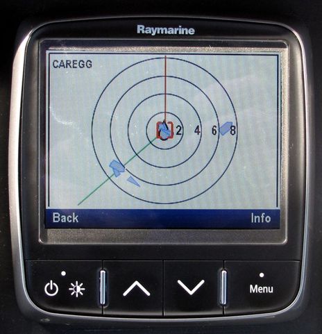
   I also experienced some NMEA 2000 plug and play goodness, as with that nifty Raymarine i70 in the top photo. (I got a taste of the i70's unique and useful AIS display last fall, but didn't realize it can even scale targets.) As soon as it was on the same network with the B100, it started showing AIS targets and after a while it had all of each target's static data available under that Info soft key, which elicited a whoop of surprise because that was not the case with the Raymarine e7...

Em-Trak_B100_N2K_AIS_on_Raymarine_e7_n_Simrad_NSS8_cPanbo.jpg

Actually the first MFD I networked to the B100 was that Simrad NSS above left, and I had low expectations because of recent comments on the original Em-Trak entry. Navico, after all, had been first with a Class B transponder that output NMEA 2000 and they'd had to write a proprietary PGN for the Class B static data because NMEA hadn't finished it yet. Plus they programmed their MFDs to understand that special PGN. Fine and dandy, but that was years ago, and yet it seems that Navico has not yet updated its transponders or its MFDs to work with the standard messages (as I had presumed). It doesn't matter how long you leave that NSS on, it only sees Class B targets as an MMSI number with position, course, speed, etc...never the vessel's name, call sign, type, and dimensions.
   So I thought I'd motivate Navico to fix this by setting up the Raymarine e7 up on the same network and photograph its complete listing of the same AIS targets. But the e7 failed to get Class B static data over N2K too!...

Em-Trak_B100_N2K_AIS_on_NMEA_Reader_via_Actisense_NGT__cPanbo.jpg

Could there be something amiss with the output of the B100? Nah. Above is a screenshot of the same data stream as seen in Actisense's NMEA Reader on Gizmo's Mac Mini (via the same company's gateway, which makes it available to many charting programs on the PC). It sure looks like the B100 is putting out PGNs 129809 and 129810 -- also known as the Class B "CS" Static Data Reports, both A and B -- that make sense in the official Standard that Actisense used to parse and label the fields...

Em-Trak_B100_N2K_AIS_on_Garmin_7212_cPanbo.jpg

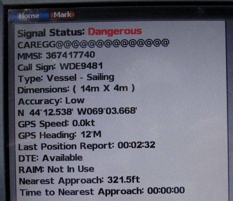
And the good old Garmin 7212 -- which along with a Garmin AIS 600, has been doing AIS over NMEA 2000 fine for a long time on Gizmo -- didn't have have any trouble with the B100 output either. Well, I will take this opportunity to chide Garmin again about its AIS alarming. A vessel can be 321.5 feet away from mine and not be Dangerous, for days at time in fact, and thus it's annoying to get alarmed every time I turn the Garmin on...

Vesper_Marine_WatchMate_Class_B_display_cPanbo.jpg

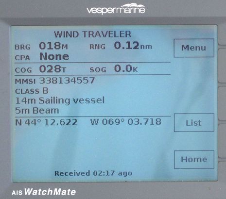
Actually, all the MFDs I've used with AIS could use improved alarming, I think, and Vesper Marine has been providing examples of how to do it right for years. They have also demonstrated how to present target data well (and note that the WatchMate stripped those "@" space symbols out of the Class B vessel "Caregg" name as did the Ray i70 above). Vesper is about to enter the world of AIS over NMEA 2000, and WiFi, and I'll bet they do a great job of it...

Em-Trak_B100_N2K_AIS_on_Coastal_Explorer_2011_via_Actisense_NGT__cPanbo.jpg

Another AIS plotter to watch is Coastal Explorer, which is now ranking targets in the "Passing" categories seen above. I just noticed this feature today, but I think I like it a lot. The Class B sailing yacht Isobel was not going to collide with me in Camden Harbor, but it was neat the way it jumped to the top of the list after it tacked. Another neat thing about the screen shot is that though CE works great with N2K AIS, the data above is actually a NMEA 0183 log collected by the Em-Trak B100 on an SD card. I just had to rename the file extension "nmea" and the free utility GPSGate will play it to virtual com ports, TCP/IP, etc where most any charting/AIS program should be able to read it. I'm not sure if there are file size limits -- three hours of this sort of AIS density equals a 3 mb file -- but I think I have a voyage recorder now!
   And, incidentally, I think the AIS range I'm seeing from Camden Harbor is as good as, or better than, any other AIS receiver I've tried, and the transmission range looks good too (I can see Gizmo via my shore listening station a mile away, which isn't true of all Class B's because there's a lot of earth and trees in between). Plus the Em-Trak B100 -- $550 at West Marine -- is not the only economical N2K Class B transponder these days. How about the Si-Tex Metadata, which looks like a close cousin to the B100 except that it has an internal GPS antenna to make installation easier.
   But here's the thing: I'm pretty sure that none of these AIS transponders will work to complete satisfaction over NMEA 2000 with the current MFDs of two major manufacturers, and that just doesn't seem right. Unless I somehow messed up my testing -- which in fact is largely confirmed by the PGN lists being collected by the great Panbot "Norse" -- you will not see the names and details of Class B vessels on current Navico and Raymarine MFDs. I know there's a lot of history to this -- heck, the late development of AIS message 24 caused Class B users to think ships didn't see them before the lateness of the PGN equivalent caused this little mess -- but I think it's easily fixed in this case. I'm pretty sure that an MFD can be programmed to recognize both the standard PGNs and the proprietary one a company may have already written (though I'd like confirmation of that).

At any rate, I'm not quite ready to publish the PDF seen below -- I want the manufacturer responses first, and there are more products to add -- but it will hopefully become a real world list of what does and does not work when it comes to networking AIS transponders and AIS plotting devices over NMEA 2000. When it works right, AIS over N2K is great...easy to install, easily distributed around a boat, and hopefully future proofed...but it doesn't always work right.

AIS_over_NMEA_2000_info_sheet_cPanbo.jpg 
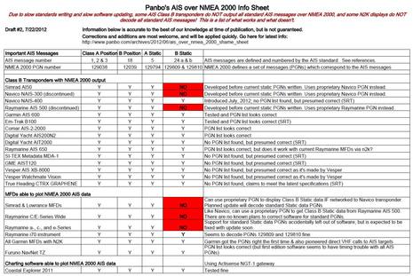
PS 7/22: I finally have the whole Panbo AIS over NMEA 2000 Info Sheet.pdf ready for download, and I'm glad I waited as there have been several positive developements in the meantime. I've already seen full Class B data over N2K on a Simrad NSS, for instance, though the actual software update is still not released. I trust that Raymarine is headed the same way, and both companies now have transponders that use all the standard PGNs. In fact, I've edited "shame" out of the sheet. Nonetheless it can help boaters with older N2K transponders and displays to understand possible limitations. Plus the document now includes a brief history of the AIS standard that I wrote and some excellent reference material collected by Panbo reader Norris. Thanks, Norris!

Comments

Sometimes it is unbelievable how slow NMEA 2000 development is...

I heard that Navico is going to release a replacement for the NAIS-300, I guess that once that is released they will fix this silly Class B omission in the MFDs.

Posted by: Kees at June 11, 2012 4:38 PM | Reply

Ben,

Aren't the Raymarine AIS 650 and Em-Trak B100 essentially the same and therefore score the same on your Shame Sheet?

Don

PS: See you in Camden or somewhere Downeast soon

Posted by: Don Joyce at June 11, 2012 4:54 PM | Reply

Seems to take a while

http://www.yachtbits.com/navico/_nais_300_class_b_ais_transceiver.php

......THIS PRODUCT IS NOW DISCONTINUED - REPLACEMENT VERSION DUE EARLY MARCH - PLEASE EMAIL US AND WE WILL KEEP YOU UP TO DATE WITH THE REPLACEMENT......

So I bought a digital yacht transponder.
CTRX+actisense was giving vessels in the wrong direction on the screen.

Posted by: Hendrik at June 11, 2012 5:18 PM | Reply

Hendrik,

Guess they are waiting with the release until the chartplotters can actually use the new product aka the new software ain't ready?

Are you using NMEA 2000 with the Digital Yacht transponder or have you given in as to the wrong direction? I've got wrong direction on some AIS vessels as well, with my NAIS-300 -> N2K -> Lowrance HDS system. Disappointing, and I was hoping every time that new HDS software would fix this. 2 years on and no luck.

Posted by: Kees at June 11, 2012 5:27 PM | Reply

I left the Em-Trak B100 running this evening and you can see it on ShipFinder. But more interesting is the fact that big yacht called Blind Date apparently burned and sank off Sandy Hook, NY, late this afternoon. You can see some of the emergency response boats still on the scene and if you look at the track of the yacht Erica XII you'll see how it ran a search grid. I think everyone survived:

http://goo.gl/ExRt6

Posted by: Ben E at June 11, 2012 7:26 PM | Reply

Raymarine and Navico are sufficiently large, well-supported outfits that I would expect more up-to-date firmware from them.

I would have a really hard time faulting smaller shops on this issue, though. Consider a team of four or five engineers and coders, swamped in bug reports and feature requests, with a growing list of products that were supposed to ship yesterday. They can easily be forgiven for leaving something like AIS-B static data parsing on the heap while more pressing issues are addressed.

Posted by: Matt Marsh at June 11, 2012 7:33 PM | Reply

I am looking to purchase a radar/MFD, AIS system and DSC radio, and rather like the Em-Trak B100 for its low cost, so have been following this with interest. Given the issues in this post, the limited NMEA 0183 inputs to MFDs and a strong desire to avoid purchasing a NMEA multiplexer, it would suggest that a standalone AIS display is the best route. Assuming I stick with standards-based solutions, the cheapest option (since I need a DSC radio) would be a GX2000 from Standard Horizen, but the AIS display on this unit has very limited resolution. The next cheapest option would be a display from Vesper, and the most expensive (although most flexible) is a Raymarine i70. I suppose a dedicated Lowrance HDS-7m could be standards-based by using a dedicated NMEA 0183 input, although it goes against my grain to purchase one knowing they don't currently adhere to the NMEA 2000 standard. Can you comment on your preferences for these last options? Given that Vesper does not publish a manual online, and that Raymarine publishes precious little info on the AIS application within the i70, it is difficult to compare these two options.

Posted by: Doug McEwen at June 11, 2012 7:40 PM | Reply

Ben,

You mentioned having a sort of "voyage recorder" now. I really like the idea of creating a record of the last 30 minutes of what's going on around me. Coastal Explorer ECS, the commercial version of Rose Points software, does have a real voyage recorder. There is a YouTube training video that covers this feature. Wish Rose Point would add voyage recorder to the 2011 recreational version or sell it as an "add-on" feature.

I agree, Coastal Explorer handles AIS really well.

Posted by: Richard C at June 12, 2012 8:36 AM | Reply

A very instructive test, as always, thanks !

It would have been interesting to add one more test based on iPad with iNavX + the SeaSmart WiFi gateway. Any chance to add this one to your list ?

Posted by: Dominique at June 12, 2012 8:46 AM | Reply

Weird that the yacht fire off NY turned out to be a false alarm compelling enough to scramble 7 helicopters and all manner of boats and ambulances: http://goo.gl/WvCWK

Richard, "voyage recorder" is probably an overstatement on my part but the Em-Trak B100 does save your own vessel track (if the GPS strings were enabled using ProAIS) and AIS target data in a standard NMEA 0183 file that looks like this:

"$GPRMC,192121.00,A,4412.50580,N,06903.72587,W,0.045,,090612,,,D*6A
$GPGGA,192121.00,4412.50580,N,06903.72587,W,2,12,0.78,7.2,M,-30.3,M,,0000*69
$GPGLL,4412.50580,N,06903.72587,W,192121.00,A,D*7E
$GPGBS,192121.00,1.9,1.4,2.0,,,,*46
!AIVDM,1,1,,B,15N;VCg000s4IoTIEVhbc@bd28 !AIVDO,1,1,,,B5NI4OP00>hugK6DgH86OwbUoP06,0*54"

I could not get it to work right using the undocumented and unsupported log file playback in CE 2011. But it plays back in GPSGate fine, and using that I can watch my track and all AIS targets play back in CE. Could be particularly useful if someone strange happened like the Blind Date thing.

I wonder, BTW, if the authorities checked Marine Traffic (or a more complete private or gov. AIS tracking service). On MT I see one 150 foot Blind Date (MMSI: 378344000) underway in the Med right now, while another one (MMSI: 319009300) was last seen in Miami 83 days ago.

Posted by: Ben E at June 12, 2012 9:12 AM | Reply

Doug, I'm not following your reasoning well. I think that the Standard Horizon AIS Matrix products are great for certain uses -- like smaller boats, backup AIS display, DSC calls to targets -- but it would seem a shame to install a full transponder and only have a GX2000 for display.

I think I should emphasize that AIS over N2K works really well except for this business of Class B static data, which is what makes that ongoing glitch so irritating. Especially as it could be easily fixed, I think. Maybe Kees can confirm that the way NMEA 2000 works, his Lowrance HDS could be deciphering the standard 129809 and 12810 PGNs while also still supporting Navico's proprietary equivalent?

I haven't heard back from Navico but I think Raymarine is surprised about the problem I'm seeing (which I double checked yesterday using a different N2K network). And they may have the same problem with their own AIS650 as Norse found that it claims to use the standard 129809 and 10 PGNs (and also, as Don notes, is very likely manufactured by the same company that makes the Em-Trak).

I think this glitch will get straightened out, but, Doug, have you considered Garmin? I've already seen that my test 7212 works fine with the Em-Trak B100 -- and probably all the other new N2K transponders coming to market -- and I'll bet that it can use this standard target data to place DSC calls on its VHF radios, all via N2K.

Posted by: Ben E in reply to Doug McEwen at June 12, 2012 9:32 AM | Reply

I like my early NAVICO 300 unit with my Garmin network. My best MFD is a Garmin 6212 but it does not provide me with the Class B vessel name. Other then no vessel naming of AIS class B vessels all the other data shows up on all the MFDs those on the NMEA2000 network and Garmin network and can be reviewed.
I have the latest software in the Garmin 740s, 4210 and 6212. My NAVICO's AIS300L has firmware revision is 1100 100101.
Is there a Navico update for the AIS class B transponder I am unaware of?
Bill Lentz
MV Wireless One

Posted by: Bill Lentz at June 12, 2012 10:42 AM | Reply

Bill, Apparently Navico never updated the NAIS 300 (now discontinued according to a comment above) or the Simrad AI50. Nor did they update their MFD software so that it can also decode the standard Class B static data messages. So while Navico transponders and MFDs work fine together over SimNet/N2K, neither is completely compatible with other brand MFDs or transponders.

Posted by: Ben E in reply to Bill Lentz at June 12, 2012 11:25 AM | Reply

If your AIS indicated that there was a danger, one of the options that is a valuable feature is the ability to call the other vessel on the VHF. For that it would be helpful to know the name of that vessel. That should be there now.

Another feature is to call using MMSI. For that it would be helpful to be able to avoid keying in all those digits. That should be coming "soon".

Eventually, all AIS units will follow the standards and the features which distinguish them will be things like VHF antenna splitters and other things not specified by the standards. (The standards for Class A and Class B should be pretty stable by now, although other new features can be expected and it takes time for them to filter down through all the layers of organizations involved.)

The real action will be in the MFD or dedicated displays, in how they present the information to the user. There is a lot there that could be improved. Personally, I like the idea of layers, each of which can be quickly and easily flipped on and off: chart, radar, ais.

BTW, it seems someone forgot to tell Simrad that the NAIS-300 is discontinued; it's still on their web site with no mention of that or its replacement.

Posted by: norse in reply to Bill Lentz at June 12, 2012 12:28 PM | Reply

@Ben,

Yes, receiving multiple PGNs should not be hard to program. There are various strategies of course: - listen to both, - ignore the standard one if you see any proprietary ones, - ignore the proprietary one if you see any standard ones.

@Bill,

Unfortunately the NAIS300 cannot be field upgraded apparently. It is a slightly different beast from other Simnet devices. It actually contains a normal NMEA0183 SRT AIS circuit board as well as a Navico built NMEA2000 interface. I had a Simrad distributor round about a year ago and he was able to update my IS20 displays etc., but he did not have any updates for some others such as my WR20 and NAIS300. This did not matter as they were running the 'latest' version. Having customers flash new updates is something that is both good (we get updates) and bad (companies feel they can ship not-yet-ready products).

What Navico doesn't have yet is some user capability of updating non-MFD/Radar devices as the updates are only given out to dealers that have a programming device.

Posted by: Kees at June 12, 2012 1:12 PM | Reply

Kees,
Could be, it is silent at Navico a this time. Expecting new NSE/NSO software and Gofree any minute, day, week, month.
Direction is okay now with my NMEA2000 Digital Yacht transponder.
Don't know what you mean by ...or have you given in as to the wrong direction?...
I also complained about the moored AIS vessels that still sound the dangerous vessel alarm mor than a year agoo, but still no solution. Very annoying in our harbour

Posted by: Hendrik at June 12, 2012 1:26 PM | Reply

Thanks to everybody for raising this. As I am about to upgrade my equipment, reading this I get annoyed. I exactly have the combination of an AI50 together with i70 displays and a Maretron compass. The latter two talk well to another. However, it seems that the representation of AIS data on the NMEA2000 bus will be incomplete. To make things worse, it seems that the AI50 does not accept HDG data through its NMEA0183 interface, ut only through 2000. As I also face the challenge to channel all this into and out of my Transas NaviSailor plotter, it seems I will eventually end up with two parallel networks. Does anybody know if there is a possibility to
a) make the AI50 accept HDG data via 183,or
b) enable it to digest HDG via 2000 without sending AIS data on the bus or
c) get the proprietary class B static info converted to the standard PGN by an external unit?

Best
Peter

Posted by: Peter Daum at June 12, 2012 1:31 PM | Reply

Kees,
I see that your Merrimac and my Aalscholver are only a few miles away from each other

http://www.marinetraffic.com/ais/shipdetails.aspx?mmsi=244620063&header=true

Posted by: Hendrik at June 12, 2012 1:35 PM | Reply

I am able through my Garmin plotter the Navonics AIS class B and my Garmin VHF200 (either one) call a ship through the VHF radio without having to enter the MMSI. That feature works quite well.
Bill Lentz
MV;Wireless One
MMSI;338065206

Posted by: Bill Lentz at June 12, 2012 4:43 PM | Reply

Peter I also use a Maretron NMEA2000 heading sensor along with numerous Garmin NMEA2000 sensors and weather receivers. My NAVICO AIS unit works extremely well my main complaint is I can't find a local NAVICO dealer that can upgrade or program the NAIS300. I have a spare but both have my MMSI entered in them. It is used on my NMEA2000 network using their adapter cable that came with both units. I had a self alarming AIS problem which was fixed with a Garmin update on the MFD's. The MFD's thought the NAVICO was a threat but Garmin now gives you the ability to enter your MMSI this eliminated my own vessel from being a dangerous target. It took a bit longer to get the 740s updated. However I would still like to see the vessel name from other class B AIS vessels.
Bill Lentz
MV;Wireless One

Posted by: Bill Lentz at June 12, 2012 5:00 PM | Reply

I have a Digital Yacht AIT2000 which works faultlessly with my Garmin 5008. From the Garmin MFD I can instigate a call to any chosen AIS vessel via my Garmin VHF200. It all integrates nicely over n2k for me.

Posted by: Keith at June 13, 2012 1:34 PM | Reply

I hope that Garmin's involvement with Americas cup will lead to a new set of plotters that blow Simrad nss and Ray out of the water.

I just did a leg... arrived a few hours ago
.. from Jupiter FL to Beaufort NC.
. 3 day sail. The plotter had to be rebooted about once a day or it went crazy. The Raymarine knotmeter looses its calibration for no apparent reason. The Raymarine autopilot went to standby and the boat rounded up all by itself. This is inexcusable.

At Miami show a nice guy at Simrad said that since they are owned by private equity they don't fix bugs. ... people buy new products and features not bug fixes.

Is it true that Garmin stuff has fewer bugs?? I'm a custo

Typing this on a phone so sorry for the typos

Posted by: s/v Haven at June 13, 2012 3:29 PM | Reply

I'm tickled that reading Panbo is one of the first things you did ashore, but maybe you need a nap? I'm sure that Simrad and all the other marine electronics companies -- regardless of ownership structure -- know that their reputation for supporting their products is a critical sales component.

Posted by: Ben E in reply to s/v Haven at June 13, 2012 4:32 PM | Reply

Great article Ben and your findings pretty much match what we are hearing from our customers. Fortunately connecting a Class B transponder via NMEA 0183 is a good work around for Navico and Raymarine customers that cannot get static Class B data via NMEA 2000 but it would be great if new firmware updates become available very soon.

I think it would be good to add the AIS SART support to your Shame List table as this will be the next area of confusion and incompatibility - one of the reasons we have developed our AIS Life Guard product.

Paul Sumpner (Digital Yacht)

Posted by: sumps.myopenid.com at June 16, 2012 1:22 PM | Reply

Good news re: Raymarine c- and e-Series and the standard Class B static data PGNs. While Ray acknowledges that they forgot to include them, apparently they are being tested in a beta software update that is scheduled for release in July.

I have not heard back from Navico about this, but will bug them again.

PS. Thanks, Paul S. Judging from the other thread, it is looking like a spreadsheet about AIS SARTs and MoB devices and how they're plotted may be in order. But so far the nuances don't seem related to which NMEA protocol they're received on.

http://goo.gl/V2iCb

Posted by: Ben E at June 16, 2012 4:29 PM | Reply

Ben, a few messages above you include a NMEA message string, the last two sentences being:

!AIVDM,1,1,,B,15N;VCg000s4IoTIEVhbc@bd28 !AIVDO,1,1,,,B5NI4OP00>hugK6DgH86OwbUoP06,0*54

Note that the !AIVDM message is ill-formed, with no parity at the end. Is this just a typo?

Posted by: Paul in reply to Ben E at June 17, 2012 2:09 PM | Reply

No one typed that, Paul; the NMEA text was cut and pasted from a log file created by the Em-Trak B100. I'll try to record one that's reasonable file size and includes AIS SART testing, and make it available for download.

Posted by: Ben E in reply to Paul at June 18, 2012 7:10 AM | Reply

Got preliminary good news from Navico, with promised confirmation tomorrow. When published, the Shame Sheet my be short lived, at least for products currently in production.

Posted by: Ben E at June 18, 2012 3:18 PM | Reply

Let's hope so.
Any news about Gofree by the way?

Posted by: Hendrik at June 18, 2012 4:48 PM | Reply

Ben, I am all ears hopefully a upgrade for the NAIS300? I bought a spare when they came out.
Bill Lentz
MV; Wireless One

Posted by: Bill Lentz in reply to Ben E at June 18, 2012 6:25 PM | Reply

It was a vague message, Bill, and I think I should have said "MFDs currently in production"; I'm getting the impression that transponders are not easy to update.

Posted by: Ben E at June 18, 2012 7:09 PM | Reply

I would send the (2) NAVICO NAIS300 out if I could find someone who could update them in the southern New Jersey area. One needs the old MMSI removed and a new MMSI put in it for my 22' center console. If there is a factory update for the missing static Class B AIS I would have both upgraded. My installed AIS300 has my MMSI from the Mainship.
Bill Lentz
MV; Wireless One

Posted by: Bill Lentz at June 18, 2012 11:51 PM | Reply

Bill, you can reset the NAIS-300 to factory default after which you can program in a new MMSI using ProAIS (the software that came with the device.)

See http://yachtelectronics.blogspot.nl/2011/02/srt-proprietary-ais-commands.html last paragraph.

Posted by: Kees in reply to Bill Lentz at June 19, 2012 3:25 AM | Reply

Navico AIS N2K news confirmed: An "RTM2" update for the Simrad NSS Series expected to "release within a couple of weeks" has "support for PGNS 129809 and 129810 to decode standard AIS Class B Static Data" (and lots of other enhancements).

Plus, since most Navico displays are based on a common operating system code (NOS), "the AIS feature will make it into other products as SW updates develop across each brand’s product line."

Posted by: Ben E at June 20, 2012 11:24 AM | Reply

Thanks for keeping us posted. So, no good news on the AI50?

Posted by: Peter Daum at June 20, 2012 5:37 PM | Reply

Peter, the AI-50 and NAIS-300 use a technology that does not support user field updates.

if you have an AI-50 or NAIS-300, and you want Class B AIS information on a non-Navico MFD, your best bet is probably NMEA-0183.

Another option would be to feed this through an Actisense NGW-1 and let that convert the NMEA-0183 to NMEA-2000. I think Hendrik here did this for a while before he upgraded to a new AIS transceiver?

Posted by: Kees in reply to Peter Daum at June 20, 2012 6:08 PM | Reply

Thanks for the clarification. I think the 183 route would be feasible provided that the AI%0 is willing to accept HDG information from the compass by 183 as well. Unfortunately, it seems that the only way to get the compass heading into the AI50 is 2000. A split setup (183 for getting AIS out, 2000 for getting HDG in) is in my opinion not desirable.

Posted by: Peter Daum at June 21, 2012 1:49 AM | Reply

Kees,

Correct and static data was visible then.
NGW-1 is still at my desk, willing to be sold.

Posted by: Hendrik at June 21, 2012 1:19 PM | Reply

You could try Panbo Classifieds, Hendrik. It's totally free and has worked for several people, including me. (I just can't figure out why more people aren't using it?)

https://www.panbo.com/classifieds/

Posted by: Ben E in reply to Hendrik at June 21, 2012 3:08 PM | Reply

Well Ben, it looks like you got a result with your Shame List and I look forward to seeing Navico and Raymarine updates in the not too distant future.

Well done !

Posted by: https://www.google.com/accounts/o8/id?id=AItOawl7a6aQBkcrdq6YZBaD_2CTSPlRQjeYQj4 at June 22, 2012 10:17 AM | Reply

Thanks Ben,

Will be expensive on delivery costs.
I'll put it on our Market Place (Marktplaats.nl) again.

Posted by: Hendrik at June 22, 2012 1:22 PM | Reply

Sorry to report that I am having a (small) issue with the Em-Trak B100. I can not get it to output target data over USB and NMEA 2000 simultaneously. It will do either output fine by itself but not both at the same time. Em-Trak is investigating.

Posted by: Ben E at July 11, 2012 11:27 AM | Reply

Actisense is sold, sent and delivered to it's new user.
Thanks to Panbo!

Posted by: Hendrik at July 11, 2012 3:03 PM | Reply

Good news -- I just noticed this on a Simrad website:
NAIS-400 AIS
"latest generation, fully integrated, Class-B AIS transponder"
http://www.simrad-yachting.com/en-US/Products/AIS/NAIS-400-ClassB-AIS-en-us.aspx
USB type A plug [but the manual says mini-B], NMEA 2000 *standard* connector, plus NMEA 0183 at both speeds.

Configuration is with proAIS2, which I believe indicates that the AIS engine is by SRT.

This quote is in the Troubleshooting section of the manual, in response to "My MMSI is being received by other vessels, but my vessel name is not shown on their chartplotter or PC":

Some older AIS devices and chartplotters do not process the specific class B AIS message, which provides the vessel name (message 24). This is not a fault of your AIS transceiver. Software upgrades are available for many older chartplotters which will correct this issue. The other vessel should update its AIS unit and/or chartplotting software to receive AIS message 24.

An antenna splitter specific to this unit is also available.

Posted by: norse at July 22, 2012 2:08 AM | Reply

Good catch, Norse. I agree that it's likely built by SRT but sort of odd that Navico removed the SD card logger. That's a feature they pioneered in the Simrad AI50!

Posted by: Ben E in reply to norse at July 22, 2012 1:44 PM | Reply

Incidentally, I finally made the whole "Panbo AIS over NMEA 2000 Info Sheet" into a downloadable PDF, which you'll find in the PS above. And, yes, I even took "shame" out of the title, because a lot of headway has been made, or will be made with software updates "coming soon." But there are still issues for owners of older N2K transponders and MFDs and I hope the sheet clarifies them. It now also has some good reference material thanks to the efforts of Norse.

Posted by: Ben E at July 23, 2012 3:12 PM | Reply

Oops,

New Digital Yacht AIT2000
NSE12 and NSO

But no names on AIS B Vessels

Posted by: Hendrik at July 24, 2012 5:35 PM | Reply

Don't despair, Hendrik, but patience may be required. Like the info sheet says Navico plans a software update that will decode the standard Class B static data. In fact, the NSS8 on Gizmo is now decoding Class B fine, because it's running an early copy of a software release that's due out quite soon (lots of other improvements and fixes too). The new code will eventually get to NSE, NSO, and I think the Lowrance MFD line too. You will see Class B vessel names, dimensions, type, and call sign with that DY transponder, eventually.

Posted by: Ben E in reply to Hendrik at July 24, 2012 5:46 PM | Reply

I don't Ben :-)

Maybe all will come at once.

Navionics chart update, so radar and AIS overlay's will fit the chart.
NSE and NSO updates.
Gofree.
AIS alarm off for ships that don't move.
Current vectors like we were used to on the CX44
Possibility to draw lines on the charts like on the CX44

etc.

Posted by: Hendrik at July 26, 2012 7:29 AM | Reply

I'll second your request Hendrik, especially for the current vectors!

I don't understand your first point though, "AIS overlays will fit the chart"?

Posted by: Kees in reply to Hendrik at July 26, 2012 10:18 AM | Reply

Aalscholver symbol, Radarimages and AIS Vessels are 30 metres off position on my Navionics maps. Ehh, I mean the maps are off.
Map correction is on its way for almost a year now.
Navionic promised me it would be solved this summer

Posted by: Hendrik at July 26, 2012 1:35 PM | Reply

I installed a Furuno NN3D MFD8 when this modell was brand new.

This year i decided to upgrade with
-AIS Class B Transceiver em-trak B100
-New instruments Raymarine i70

Heading data come from a NMEA 0183 heding sensor connected to the NN3D and is shared on N2K network

Connected the the NN3D and the em-trak to the StNg network.
First I discovered that the NN3D does not take AIS data on NMEA 2000 (my fault should not have assumed that). Connected those two using NMEA 0183 (also).

Some observations;
The NN3D does not know what a AIS base station is...

When the NN3D unit is turned off, the i70 claims that the AIS is off when it is not (the power to the N2K network is not supplied by the NN3D).
Guessing that the message on the i70 should be no heading data?

The i70 is much better at displaying data about the AIS targets and use different icons for base stations and other targets.

Does anyone know how AIS-Sart's will be diplayed on i70 and NN3D?


Posted by: Knut at August 5, 2012 7:34 PM | Reply

Hi Knut,

The i70 acknowledges AIS SARTs but needs work, example here: http://goo.gl/V2iCb

I think it may also need a fix regarding AIS display and Heading. At least once my test i70 didn't display N2K AIS data from a Ray AIS 650 (sibling to EM-Trak B100) when the N2K compass was detached. Will check out further, as there's no reason why, I don't think.

I don't have a NN3D MFD for testing anymore but hope to try the TZTouch, which does receive AIS over NMEA 2000.

Posted by: Ben E in reply to Knut at August 6, 2012 7:00 AM | Reply

Thank you.

There is probably hope for a new SW from Raymarine since this is new devices..

Only problem is that there are no Raymarine plotters in my network - so updating will require some work.

I'm not that optimistic about new SW for the NN3D since it has been replaced by TZTouch.

Support from Furuno Norway is non existent for the NN3D. The don't bother to answer support requests..

Posted by: Knut at August 6, 2012 6:13 PM | Reply

Ben, I am about to install my em-trak b100 and a new NavNet3D 8-inch MFD. Have you heard any feedback as to whether that configuration properly handles the N2k data issues? Thanks.

Posted by: Jeff at August 18, 2012 8:12 AM | Reply

Jeff, NavNet3D never had any issues with AIS over NMEA 2000 because it doesn't support it all! But you should be able to wire the B100 NMEA 0183 output to the MFD8 just fine, and if you get another NN3D MFD it will get the AIS over Furuno's Ethernet network.

Furuno has changed its AIS ways with the new TZtouch series. It accepts AIS over N2K. The only boat I've seen it installed on has problems with AIS over N2K or from Furuno's own FA50 via Ethernet, but apparently it's the only TZT install that's had such problems.

Posted by: Ben E in reply to Jeff at August 18, 2012 8:39 AM | Reply

Hi Ben,

If I understand you correct, the new Simrad NSS software will make the MFD talk NMEA2K AIS with native AIS NMEA2K equipment?

Do you have any information regarding when we can expect a similar software update for the NSE units?

BR
Mikkel

Posted by: Mikkel at August 20, 2012 11:51 AM | Reply

Correct, Mikkel. As promised the new NSS software decodes the standard NMEA 2000 static data messages fine now. I've seen it in action. And, yes, I've heard that the code will be added to future NSE and other Navico MFD updates.

Posted by: Ben E in reply to Mikkel at August 20, 2012 12:57 PM | Reply

Good news: Raymarine just introduced software version 4.27 for c-Series and e-Series, and it includes full support for the NMEA 2000 Static Data message. There's also all sorts of enhancements in what's called Lighthouse V4, info and video here:

http://www.raymarine.com/default.aspx?site=1§ion=2&page=2070

The Shame List is dwindling fast!

Posted by: Ben E at August 24, 2012 1:24 PM | Reply

Ben; just to confirm the nss update which is their 2.0 software version DOES address the missing AIS static data? I read the description of the what is contained in the update and see no reference to anything AIS-ish. It could just be my ignorance showing.

As always, thank you for your help.

Ed

Posted by: ereiss at September 11, 2012 3:42 PM | Reply

Kees reviews the Navico NAIS-400 here:
http://yachtelectronics.blogspot.ca/2012/11/navico-nais-400-reviewed.html

It supports both the new and old Class B PGNs.

There is a software upgrade for the NAIS-400 announced here:
http://www.simrad-yachting.com/en-US/News/2012/New-NAIS-400-software-now-available/

The new software allows the SimNet or NMEA 2000® network to use the NAIS-400 as the source for position data, thanks to the enabling of new NMEA 2000® sentence transmission.

The equivalent Lowrance page says:


The new software allows the NAIS-400 to transmit the following NMEA2000 sentences.

PGN129026 COG and SOG, Rapid Update.
PGN129025 Position, Rapid Update.

http://www.lowrance.com/en-US/Software-Updates/NAIS-400-AIS/


Posted by: norse at December 19, 2012 1:17 PM | Reply

I know this might be a bit off topic, but can anybody explain why we don't see any ais class a transponders with nmea2000 interfaces.

As rules are changing now in EU all recreational boats above 18m needs to have class a transponders from 2013 and 15m from 2014, I would expect the market for class a receivers to be a lot bigger soon?

Posted by: Mikkel Mandrup at January 2, 2013 1:43 PM | Reply

Mikkel,

Do you have a reference to a source for that change in EU regulations?

Posted by: Kees in reply to Mikkel Mandrup at January 2, 2013 1:50 PM | Reply

I did a bit of searching, and EU recreational boaters don't need to worry.

There is an EU regulation 2009/17/eg that enforced AIS class A on fishing vessels larger than 15m. See http://eur-lex.europa.eu/LexUriServ/LexUriServ.do?uri=OJ:L:2009:131:0101:0113:EN:PDF
The only change coming in the coming few years is that these will become mandatory for existing fishing vessels, not just new ones.

Here is a Google translation of the relevant change for Dutch law, which I presume will be similar in most or all EU countries (as they have to implement regulation 2009/17/eg in some form):

The Automatic Identification System (AIS) is mandatory on all vessels longer than 15 meters. On new vessels longer than 15 meters and existing vessels of 45 meters or more, the AIS is mandatory.

For who? Dutch and foreign fishing vessels: operating in the internal waters or territorial waters of the Netherlands; landing their catch in a port in the Netherlands.

When?

The amendment shall enter into force in stages. For fishing vessels: 24 meters or more, but less than 45 meters: 31 May 2012; 18 meters or more, but less than 24 meters: 31 May 2013; more than 15 meters but less than 18 meters: May 31, 2014.

(Source: http://www.antwoordvoorbedrijven.nl/wetswijziging/verplichting-automatic-identification-system-vissersvaartuigen )

Posted by: Kees at January 2, 2013 2:24 PM | Reply

Ok, I stand corrected :)

Was information I got from a dealer, and I believe that what you has posted was what he got mixed up with some Dutch inland ais rules for recreational boats above 20m

I haven't got any links to the specific rules like you posted above, but many Dutch shops have the following information posted: http://www.shiptron.nl/php/ais_transponder.php

But thanks for the clarification.

Would still like to know if there is any good reason for class a transponders don't have nmea2000 interface :)

Posted by: Mikkel Mandrup at January 2, 2013 2:37 PM | Reply

Thanks for the good detective work, Kees!

I wonder if that over 20m inland Dutch rule isn't also limited to commercial vessels?

Mikkel, there are Class A transponders with NMEA 2000.

I wrote about the ComNav Voyager X3 here: http://goo.gl/0doFx

And today I realized that McMurdo has just introduced the SmartFind M5 that's similar but with a color screen and built-in charts:

http://www.mcmurdomarine.com/en/products/ais-electronics

Posted by: Ben E at January 2, 2013 3:56 PM | Reply

I'm impressed by the speed and qualified responses here - Thanks :)

About the Comnav transponder, I haven't been able to find information about the nmea 2000 interface ever has been activated.
In the leaflet from Comnav they still write this will be suported by a firmware update ultimo 2010...

But the McMurdo seems very interesting and priced decently.

Thanks again for the great answers from both of you :)

Posted by: Mikkel Mandrup at January 2, 2013 4:24 PM | Reply

Ben, you are probably right.

First of all, those inland regulations will mandate EU Inland AIS which is NOT Class A, although I'm not sure what the technical differences are.

Some countries like Austria have already mandated Inland AIS for commercial traffic. Also, entering Antwerp harbor in Belgium requires AIS for commercial traffic.

The Dutch authorities have so far been reluctant to make Inland AIS mandatory, largely because of widespread privacy concerns amongst the 7000+ barge shippers. The barges have largely adopted AIS anyway because they were almost free because they were heavily subsidized.

I've heard that the Dutch authorities will probably vote in favor of mandatory AIS on the Rhine in the next CCR (Central Committee for the navigation of the Rhine) meeting though. What this means in terms of who, what and when remains to be seen.

Posted by: Kees in reply to Ben E at January 2, 2013 5:05 PM | Reply

Glad to help, Mikkel. You asked an interesting question, plus I think you made Kees a bit nervous about EU requirements ;-0

I don't know what the story is with the ComNav Class A but I'm pretty sure that it's actually manufactured by SRT, which lists NMEA 2000 as an available interface:

http://www.srt-marine.com/products/oem/products/class-a

I don't know for sure but I suspect that SRT may also make the new McMurdo Class A, but haven't yet listed it on their OEM pages.

Posted by: Ben E in reply to Mikkel Mandrup at January 2, 2013 8:34 PM | Reply

Class B static data and AIS AtoNs now supported by new Simrad NSE 3.2 and NSO 1.3 software

Posted by: Hendrik at April 3, 2013 3:53 PM | Reply

This is good news. The NSE and NSO update pages say:

*April 2013 update* Added PGN129041 - AIS AtoNs (Aids to Navigation) support. Will now display AtoNs when interfaced to a compatible AIS receiver that transmits the PGN.

*April 2013 update* Added PGN129809 & PGN129810 - AIS Class-B Static Data support

The NSS update 2.5 page says:

*April 2013 update* - Support for AtoNs (Aids to Navigation)

I think the Class B PGNs were added in the NSS 2.0 update, but then so was the AtoNs PGN.

Posted by: norse in reply to Hendrik at April 4, 2013 6:24 PM | Reply

NSS new 2,5 version is on line as well from 2013-04-04

Posted by: Hendrik at April 6, 2013 6:44 PM | Reply

Thanks for keeping us 'updated' Henning! Looks like the April add-ons are:

*April 2013 update* - Support for using Navionics Silver Chart Cards on devices with no internal chart

*April 2013 update* - Support for AtoNs (Aids to Navigation)

Posted by: Ben E in reply to Hendrik at April 7, 2013 7:19 AM | Reply

Simrad is good now, but Lowrance does not yet have any MFDs, old or new, that do Class B AIS with the 129809 and 129810 PGNs, and no PGN for AtoNs either.

Posted by: norse at April 7, 2013 3:03 PM | Reply

I have an HDS Gen1, and I've given up on AIS compatibility. I'd drop in a receiver in a heartbeat if the various manufacturers would all support the proper PGNs.

Posted by: Anonymous in reply to norse at April 7, 2013 6:46 PM | Reply

It was Hendrik not me updating us on the new NSO and NSS software and thank you for that. It's downloading right now.

I use a NMEA0183-based AIS. Can I assume that NSS will display AtoNs from VDM and VDO sentences as well, even if not related to this update?

Posted by: Henning at April 8, 2013 1:20 PM | Reply

Ben is not responding to me anymore since I asked him what price I won in the "C-map on Navico products contest) ;-)

Posted by: Hendrik at April 8, 2013 2:25 PM | Reply

So now I'm totally confused..I really want to add an AIS transceiver using NMEA 2000 to my boat. I understand the Lowrance HDS display have issues with the standard Class B PGN's. So I contacted Lowrance via their website to ask them specifically about support for class B PGN's.. Here is the reply.. According to them, they are supported. According to everybody else, they are not.. Clear as mud... Here is their response, and my original question below.

---------------------------------------------------

Yes, the HDS-8 will support these PNG'S.
Thank you for choosing Navico products!
Navico Technical Support

Navico Inc.
410 Amherst Street
Suite 110
Nashua, NH 03063
USA
E-mail: [email protected]
Website: http://www.navico.com

--Original Message--
From: andreas
Date: 4/8/2013 4:21:41 PM
To: [email protected]
Subject: Form data from "ContactFormLowranceGeneral" (Lowrance)

Email submitted from web site:
enquiry: Product Support
model: HDS 8 Gen 1
serial:

phone:
country: Canada
question: I would like to add an AIS transceiver to my boat. I need to know if my Gen 1 HDS 8 will support NMEA 2000 PGN's 129809 & 129810. I am currently running the 4.1 software. If the two PGN's are not supported, do you have any plans on adding support?

Posted by: Andreas in reply to norse at April 14, 2013 8:26 AM | Reply

Andreas, your question was clear and we know that 4.1 doesn't support these PGNs, so the only interpretation of their response that makes sense is that when they say "Yes, the HDS-8 will support these PNG'S", they are using the word 'will' in future tense. Hopefully that means 'soon' and not 'real soon now' (for those not familiar with the software world, that is a joke). HDS software update 4.1 is dated 02/09/12 (Feb 2012) and there are no more recent updates listed.

Posted by: norse in reply to Andreas at April 14, 2013 2:01 PM | Reply

If your Mfd can handle it, make sure your ais can too.
For instance SRT needs firmware 1.7

Posted by: Hendrik at April 14, 2013 4:06 PM | Reply

Furuno released a new SW version for NN3D the other day.

From the release notes.
"NN3D V2.11 Software (latest)
...
*New: Compatibility with AIS-SART. Instead of a generic AIS triangle icon, SART icon is
displayed. AIS –SART symbols are now displayed on NN3D MFD8/12 and MFDBB
..."

Have anyone installed this SW and verified that it is working with AIS Sart beacons?

During my test I found that it ignored the AIS sart completely.

It did show up on my Raymarine i70 display and on other (non Furuno) MFD's around me.

I use an Em-trak b100
The i70 get data on NMEA 2000
The MFD8 get the same data on NMEA 0183

Posted by: Anonymous at July 3, 2013 6:34 PM | Reply

Has the emtrak the latest proAIS software?

Posted by: Hendrik at July 4, 2013 12:32 PM | Reply

Yes the em-trak is running v1.7

Posted by: Knut at July 4, 2013 5:54 PM | Reply

Leave a comment