Raymarine AIS650 & AIS350: smaller, better, and somewhat familiar
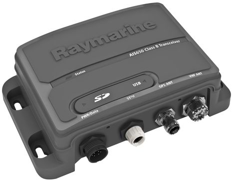
... written for Panbo by Ben Ellison and posted on Jul 19, 2011
Raymarine_AIS650_Class_B_AIS.jpg

Yesterday Raymarine issued a press release announcing replacements for its existing AIS receiver and Class B transponder, which I'll link to when possible. But, in fact, some online dealers are already offering the AIS650 Class B transponder, as well as the AIS350 receiver, and they also bear a family resemblance to the new generation SRT OEM gear discussed in June, which is not a bad thing (and no big surprise given that SRT announced a strategic agreement with one of "the world's top three marine electronics companies" last February). Let's see if we can figure out what's new and different...

Well, both these AIS devices certainly are compact and connected. Both offer simultaneous NMEA0183, SeaTalkNG/NMEA2000, and USB interfaces, so I don't think that there is an AIS plotting display alive that can't easily receive their data output. I also like how Raymarine explicitly states that its proprietary SeaTalkNG port is compatible with N2K by simply using an optional DeviceNet cable adapter (the male version, Raymarine part # A06046). And I'm fairly confident that they will interoperate fine with other manufacturer's N2K AIS displays as the early problems in that area happened because NMEA was slow to complete the AIS PGN (message) set, but that time is past. (Hopefully Raymarine will get these devices certified, but as I've been saying certification doesn't absolutely guarantee data compatibility, unfortunately.)
   I like AIS over NMEA 2000 (or SeaTalkNG or SimNet) because it thus gets to all displays without having to pass through one in particular to get onto a network and also because it usually means that a Class B transponder can easily get Heading information, which will keep your target looking right even when you're stopped. But I gather that the AIS650 does not broadcast its RAIM-verified GPS data onto N2K -- I don't think the other N2K transponders from Garmin, Navico, etc. do either -- which I don't understand. It makes sense to omit or limit GPS over NMEA 0183 because of bandwidth limitations but why not go full bore, primary-nav-capable on N2K?
   At any rate, it's nice that the new AIS650 has both hardware and software switches for Silent Mode (receive only), though I suspect the latter will only work with Ray MFDs. And I also like the new transponder's SD card for software updates, MMSI programming, and voyage data recording, though it was disappointing to hear that the latter only covers the last 30 minutes of a voyage. {Correction: The design was changed so that it records right up to limit of the card and then let's you know it's full. Nice!}  I was also hoping for lower prices than the AIS350's MSRP of $649 {Changed to $549} and the AIS650's of $999, but they are lower than the previous models and of course subject to discounting. And the competition may get intense when the very similar, if somewhat mysterious, Em-Trak B100 Class B hits the streets.
  Incidentally, the Raymarine press release states that the AIS650 has not yet received FCC approval, and therefore is not yet for sale in the U.S., but I heard yesterday that the FCC just granted that approval.
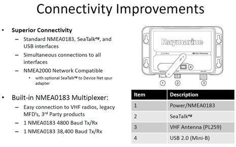
Raymarine_AIS350_and_650_connectivity.jpg

Comments

I, too, like (the concept of) AIS over NMEA2000. However, for those of us who rely on PC-hosted navigation software (rather than proprietary MFDs) the current ability to get AIS targets onto the PC using N2K PGNs is limited.

Maretron recently advised me that "...We currently do not have plans to update the AIS pgn’s into the USB100...." and recommended the Actisense gateway. The Actisense NGT-1 does support "beta" version firmware that converts AIS PGN, but has received little feedback from the user community to date.

Rose Point also offers a gateway (which I understand is based on the Actisense product) but their website is silent about AIS or any other other PGN translations. In fact, Rose Point advertises as a "feature" of their product that it functions "...without the need for firmware upgrades to support new types of devices...." I gotta wonder how that works to future-proof this product.

It seems that most, if not all, PC-hosted navigation software continues to rely on NMEA0183 sentences for nav data. As a result, a translating gateway is a necessity. Am I missing something?

Posted by: JCS at July 19, 2011 11:01 AM | Reply

Jack, I'm not aware of any beta software for the Actisense NGT-1 but I saw data from my test unit plotting AIS targets in Coastal Explorer 2011 just the other day. I haven't yet checked it out thoroughly, but it looked fine.

I realize that Actisense has updated its firmware often, but I don't think it actually translates PGNs. The hold up has more to do with the PC programs, which must be taught to decipher the PGNs. Rose Point may be only one who's done that work so far. I believe that Nobeltec is committed to it, but then again MaxSea/Furuno don't seem interested in supporting AIS over N2K for reasons I can't really explain.

Remember that the Maretron USB100 is only a true NMEA 2000 gateway in the eyes of Maretron's own software. To other software it only appears as an 0183 translator, like Actisense's NGW-1, only with a more limited translation table. Maretron could change this situation with a DLL, but apparently doesn't want to put resources into the customer support that might entail.

Posted by: Ben E in reply to JCS at July 19, 2011 11:47 AM | Reply

MacENC is among the software that directly support AIS receivers via the native N2K PGNs..

http://www.actisense.com/HTML/Products/Gateways/NMEA_2000_PC_Gateway_1/Software.htm

Posted by: GPSNavX at July 19, 2011 12:52 PM | Reply

The Actisense NGW-1 firmware that supports AIS (NMEA 2000 to 0183) is freely available after contacting Actisense support first. This step was originally put in place during the beta phase and then afterwards to avoid the situation of NGW-1 customers reprogramming their unit with the AIS version by mistake. We were concerned about the possible resulting confusion when the NGW-1 started sending NMEA 0183 at 38400 baud and only sent a reduced sub-set of GPS and a few other translations (as the AIS version has a reduced translation list).

However, we are now happy with the feedback we have received and our own testing so we are planning an official release of the AIS version very soon on the main NGW-1 download page so both versions will be easily accessible.

Just like Ben, I can confirm that CE 2011 is working well with NMEA 2000 AIS targets given to it via the NGT-1, and that Nobeltec are currently working on adding support to their own growing number of software suites.

Ben is mostly right, the AIS messages received in NMEA 0183 require rearranging more than translating, however, there are other NMEA 2000 PGN fields that have to be derived from various sources as they the complete answer is not available in the original NMEA 0183 AIS sentences. So translation is still no trivial matter.

Maxsea have issued a new release v1.9.5 that has NGT-1 support but I have not tested it yet.

The list of NGT-1 supported software is growing week by week so you could already say that the majority of chart-plotter software does support NMEA 2000 via the NGT-1.

As I understand it, the Rosepoint gateway does not translate NMEA 0183 to NMEA 2000, but instead is a "PC Interface" only gateway.

Posted by: Andy Campbell at July 19, 2011 1:05 PM | Reply

I'm a little confused, Andy.

When you write that "the AIS messages received in NMEA 0183 require rearranging more than translating, however, there are other NMEA 2000 PGN fields that have to be derived from various sources as they the complete answer is not available in the original NMEA 0183 AIS sentences", you're talking about the NGW-1, correct?

Doesn't the NGT-1 just pass PGNs to the PC? And if so, how would that be different than the Rose Point Gateway?

Posted by: Ben E in reply to Andy Campbell at July 19, 2011 1:47 PM | Reply

JCS, a presentation that was on the Raymarine web site (but stopped working yesterday) stated that the AIS messages were simultaneously available on all AIS350/650 interfaces (NMEA 0183, SeaTalkNG/NMEA 2000, and USB. Does that help answer your question?

Posted by: SheltieJim in reply to JCS at July 19, 2011 2:10 PM | Reply

Thanks very much for the comments and clarifications.

My mistake in my original post: I should have said "...the NGW-1 supports 'beta' AIS firmware..." instead of the NGT-1. Two different products for distinctly different purposes.

Thanks to Andy for correcting this error and for pointing out the link to the growing variety of PC software (navigation and otherwise) which support native N2K PGNs (to varying degrees of confidence and certification).

Finally, I now appreciate that the Rose Point gateway evidently delivers native N2K PGN to a PC (like the Actisense NGT-1) and thus may need no firmware updates to "future proof" its performance. Again, my error and misimpression.

As an owner of Maretron's USB100, I am naturally disappointed that Maretron limits its functionality in translating N2K PGN to 0183 to support legacy devices and in restricting access to N2K PGN to its own software for network monitoring and configuration of Maretron devices. However, I appreciate the market, R&D, and support constraints and am delighted that Actisense has stepped into the breach with their NGT-1 product.

Now if the industry could only get agreement on a standard, vendor-independent method to update device firmware via such a gateway....

Posted by: JCS at July 19, 2011 2:14 PM | Reply

I just got a note from Raymarine that prompted two positive changes to the entry above. Apparently they decided late to reduce the AIS350 suggested retail to $549, and it turns out that the SD voyage recording was really done right, as detailed here:

"Instead of overwriting, the SD recorder will continuously record to the limits of the card. We estimate that a 2GB card (max capacity) will hold a full week’s worth of data even in the highest traffic areas like Singapore, Rotterdam and New York.

Once full, recording stops as indicated by the LED flashing blue every 10 seconds. Hot swap in an new card (no need to power off the AIS650) and recording resumes. Once we get some more field trail data in these high traffic areas we can refine these estimates.

The data is a simple txt delimited file of the NMEA0183 data output. This data will also be extremely helpful in trouble shooting any customer issues. Simply e-mail a message log file to the Tech Support group at Raymarine."

Apparently the press release I got was something of a draft, and Raymarine will be putting up complete info on these AIS units in the next couple of days, which I'll link to.

Posted by: Ben E at July 19, 2011 2:51 PM | Reply

Ben wrote: "MaxSea/Furuno don't seem interested in supporting AIS over N2K for reasons I can't really explain"

Furuno's own AIS boxes interface to an ethernet switch. The info can then be used by MFDs, Maxsea, etc., on the ethernet network without the need to transit the N2K network.

Could it be why they're not interested in supporting AIS over N2K?

Posted by: Pandora in reply to Ben E at July 19, 2011 11:19 PM | Reply

Fair point, Pandora. Outputting AIS data to Ethernet is also a good idea, and especially useful on larger vessels. And the Furuno FA50 Class B and FA30 receiver are unique in this regard. Still, though, if Furuno/MaxSea were to program its MFD and PC charting software to also decipher AIS coming in via NMEA 2000, wouldn't users have more options regarding equipment and redundancy?

Posted by: Ben E in reply to Pandora at July 20, 2011 8:30 AM | Reply

While I fully support Ethernet for virtually everything, that is clearly not the reality at the moment. Until it is, it would be unfortunate if Maxsea, which I use and which now supports the NGT-1 for other N2K data, fails to add AIS PGN's to the list simply to push their AIS. Surely, AIS for the NGT-1 will be in the next release?

Posted by: Noel in reply to Ben E at July 20, 2011 9:06 AM | Reply

I haven't heard anything about that, Noel, but I'm hopeful. Especially since Nobeltec is being aggressive about N2K implementation and its TimeZero Trident product obviously shares a great deal of code with MaxSea TZ.

Posted by: Ben E in reply to Noel at July 20, 2011 9:19 AM | Reply

Ben,

You write:

But I gather that the AIS650 does not broadcast its RAIM-verified GPS data onto N2K -- I don't think the other N2K transponders from Garmin, Navico, etc. do either -- which I don't understand. It makes sense to omit or limit GPS over NMEA 0183 because of bandwidth limitations but why not go full bore, primary-nav-capable on N2K?

1) I'm seeing GPS data on my N2K bus from the Navico NAIS-300, so that at least does do that. Unfortunately it does not send out HDOP/PDOP so my chartplotter does not automatically select it when it is the 'best' GPS on the network.

2) All SRT boards of the previous generation (those that come with "ProAIS"), including the Navico NAIS-300, are capable of sending out not just RMC but all GPS related data over their NMEA-0183 port. All they need is a little prodding with a SRT specific command. See http://yachtelectronics.blogspot.com/2011/02/srt-proprietary-ais-commands.html for more information.

Posted by: Kees at July 23, 2011 11:14 AM | Reply

My apologies for not replying sooner, a family bereavement took me out of the office last week.

Ben: sorry for the confusion, when I initially read your comment I thought that your paragraph was talking about the NGW-1. So to clarify:

The NGT-1 "Transfers" the NMEA 2000 messages to and from the computer/embedded controller without changing the message in any way. It simply adds a wrapper to enable it to be sent on a serial link which is then striped off on reception.

The NGW-1 "Converts" the NMEA 2000 messages to NMEA 0183 sentences, and "Converts" NMEA 0183 sentences to NMEA 2000 messages. My comments about the AIS "Conversion" NMEA 0183 to NMEA 2000 was that some fields have the same values in both NMEA 0183 and NMEA 2000 so the conversion is simpler for those.

I can confirm that reception and display of AIS targets directly from NMEA 2000 (via the NGT-1) is possible with Coastal Explorer, MacENC and very recently Nobeltec VNS/Admiral. I would also expect Nobeltec TimeZero Trident to follow shortly, which will potentially lead directly to Maxsea TimeZero also supporting NMEA 2000 AIS because of their close engineering links. The more Maxsea customers that request such support, the more chance it will happen. I remember Expedition also supporting NMEA 2000 AIS targets, but I will have to confirm that.

This is just the tip of the iceberg with Fugawi Marine ENC, WinGPS and PCPlotter also making new releases now or very soon.

Posted by: Andy Campbell at July 25, 2011 6:04 AM | Reply

Thanks, Andy. I've already updated to Nobeltec 11.1 and saw it display NMEA 2000 targets via NGT-1 quite nicely this weekend. I haven't yet tried the new "NMEA 2000 Device Priority settings" but think they're the first to put this in a PC charting program. More info here: http://goo.gl/5JSdC

Thank you, too, Kees. I'm aware that some AIS transponders can output GPS data over NMEA 0183, but it always seems to be a limited subset of all the messages possible and not at high refresh rates. And this seems necessary as I think AIS is designed to use the entire 0183 bandwidth if needed. But there's plenty of extra bandwidth available over NMEA 2000, so it seems possible that an N2K transponder could also serve a primary GPS source. That's what I was trying to say ;-)

Posted by: Ben E at July 25, 2011 8:54 AM | Reply

Raymarine now has info up on the new AIS650 and 350, including an install manual:

http://www.raymarine.com/Default.aspx?site=1§ion=2&page=1718

Posted by: Ben E at July 25, 2011 9:01 AM | Reply

Is no-one else missing the VHF antenna splitter that the old models had.
They show a splitter on the block diagrams but you have to buy it from a third party. Strange.

Posted by: Derek at July 27, 2011 12:34 PM | Reply

A minor note - I discovered that my AIS650 (Firmware rev 1.7) is in fact putting GPS data onto the STNg/N2K buss whenever it is on - lat/long, SOG, COG, etc. The STNg-ST converter in turn is happily passing it to the older instruments. What I don't know is whether the GPS in my e95 "takes over" when it is turned on - but I have noticed that the ST60 speed will show the usual occasional spurious "0.1 Kt SOG" at different times than the e95 display does (while sitting still).

Posted by: Hartley at November 8, 2013 1:18 PM | Reply

I've used an SD card to record, but it was empty at the end of the trip. Do you know the problem?

When I insert it, it seems nothing happend, only th green light its's alwys on.

Posted by: manu in reply to Ben E at February 22, 2016 10:10 AM | Reply

Leave a comment