Feb 3, 2011
Panbo reader Laurence Woodward built his own 40' catamaran in Devon, England, and he'd like to use Garmin GMI 10 color N2K instrument displays at both helms. However, his mast rotates and therefore he needs some sort of sensor to keep track of that rotation, which must then be applied to the apparent wind data coming from his masthead vane (or ultrasonic). I doubt that Garmin will develop its own rotation sensor because there aren't that many rotating masts out there, but then again maybe just a software tweak to their existing rudder angle adaptor might be all it takes. Or perhaps there's another way? Let's discuss...
Continue Reading
Feb 2, 2011
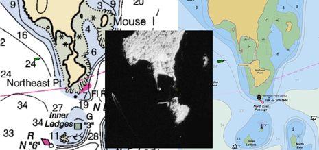
Yet another blizzard is descending on Panbo HQ, and that's excuse enough to further indulge my obsession with local charting, specifically the issue mentioned on Monday about how Northeast Point became an island. It may be a trivial matter, but it does illustrate some technology NOAA is using these days, and perhaps why we should be skeptical about the results. The collage above shows how the Point's shoreline has been depicted on the paper/raster version of chart 13307 for more than a century; the infrared aerial photograph, carefully taken near the time of mean high water, purportedly shows the actual shoreline; and the new vector version of 13307 shows how that recently acquired shoreline data was applied. The trouble is that some rocky reality seems to have been left out of the picture!...
Continue Reading
