
Garmin's latest, in Serbia
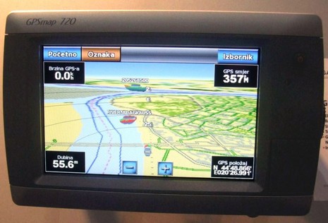
Just yesterday, in my blogging birthday post, I commented on Panbo's international reach, and today I've got some interesting evidence (and more tomorrow). That shot of the new Garmin 700 series above was recently sent to me by Petar Maksimovic of Info Team, Garmin's Serbian dealer. And there's more of interest on that screen than just the language. Info Team has been working for nearly a decade to create Serbian road and waterway maps under Garmin's MPC system, and says that its latest SCG RoadMap includes official Plovput data for about 1,600 kilometers of rivers and canals. Apparently that effort was not only an innovation for inland Europe, but also helped Info Team create a market for marine electronics. In fact, the company demonstrated some gear at the recent Belgrade Boat Show that may not have been seen right here in the world's largest ME market yet, as Petar explains...
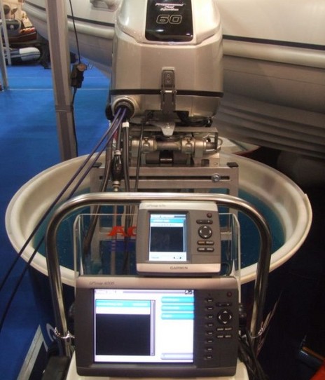
"The Serbian distributor of Honda engines, Elko Marine, managed to obtain license from the inspectors to run outboard engine indoors occasionally, to present 'digital gauges' on NMEA2000 devices. Chosen engine was new Honda BF60, and chosen display was Garmin GPSMAP 4008 due to it's portability yet large screen and VGA output (to present it on larger plasma display). Beside 4008, we also connect smaller GPSMAP 421 to see if there are difference in presented data on this portable plotter.Latest software update was needed to get all readings properly, it was done easily on both 4008 and 421 networked on N2K from one SD card inserted into 4008, real simple, as all updates were in one file downloaded from garmin.com. GPSMAP 4008 read slightly more engine data, organized in 'Engine dashboard' page, and GPSMAP 421 access similar data through 'Fuel page', or display them as number values on map page: tachometer, trim, fuel rate, fuel economy. Both devices failed to display gearbox information (F-N-R) and oil pressure, which is available when Garmin's GMI-10 is connected on Honda engines, together with Honda's 'ECOmo' display. It was interesting to learn that power has to be introduced to NMEA2000 bus to get data flowing, even though it looks like Honda interface cable introduces power to the bus similar to what Yanmar engine does."
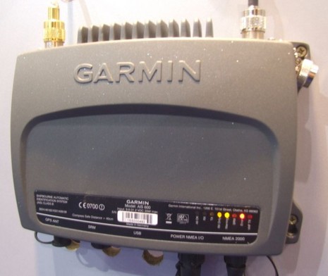
 "Another interesting electronic setup was at our Garmin
stand, where there was huge NMEA2000 network on display: six Garmin GPSMAP
plotters (new 6 & 7000 series, 720 etc...), wind sensor, VHF200 and
AIS 600 networked on same bus. Focus was on use AIS as new "safety
gadget", as there is an Inland AIS implementation project ongoing in
Serbia by local waterway authority Plovput. The new Garmin Class B transponder with NMEA2000 was powered up,
and connected to VHF antenna, sending data over NMEA2000 to all
connected Garmin GPS plotters on stand. There were no transmitting
because everything was inside, without valid GPS fix available, so AIS
600 was working as a receiver only.
"Another interesting electronic setup was at our Garmin
stand, where there was huge NMEA2000 network on display: six Garmin GPSMAP
plotters (new 6 & 7000 series, 720 etc...), wind sensor, VHF200 and
AIS 600 networked on same bus. Focus was on use AIS as new "safety
gadget", as there is an Inland AIS implementation project ongoing in
Serbia by local waterway authority Plovput. The new Garmin Class B transponder with NMEA2000 was powered up,
and connected to VHF antenna, sending data over NMEA2000 to all
connected Garmin GPS plotters on stand. There were no transmitting
because everything was inside, without valid GPS fix available, so AIS
600 was working as a receiver only. Configuration of AIS 600 was easily done via USB port and provided software, programming demo MMSI and ship data was enough to start receiving sentences from ships around: two passenger river cruisers on Belgrade port on Sava river, and one cargo passing upstream Danube." [Also see AIS screen at top.]
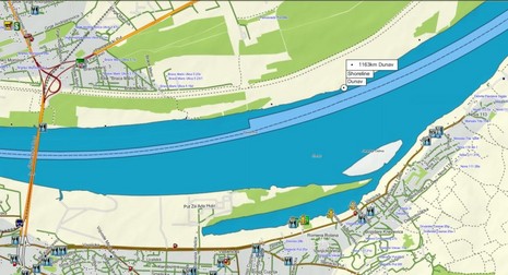
I'll close with a sample of an Info Team river map, a thanks to Petar, and a note to all: Next week Garmin is kindly bringing me out to Olathe, Kansas, for a tour and a chance to meet some its marine team. If there's something in particular that you think I should look into, please let me know in the comments below, or by email (ben dot ellison at panbo dot com).
OK - first item I need you to solve is how to connect the GHP10 autopilot to an old Perkins diesel. The GHP10 wants RPM info from the engine and this old Perkins has a mechanical tach.
I have emailed and spoken to tech support trying to figure this out for a couple of weeks now. No Joy. The phone call left me thinking that tech engineers really don't understand how the system works and how it can be bypassed. I am sure there is an elegant solution but they need to have this ready for customers. I understand the need at 30 knots. But at 8.5 knots, who cares?
Second issue, push them for a diesel fuel management system. Currently they only do gas.
If you solve the first problem I will be most indebted to you.
The new install:
Garmin VHF 300 AIS Radio Item # 36368
Garmin VHF 200 Marine Radio Item # 34170
Garmin GPSMAP 4212 Network Bundle Item # 30141
Garmin 200/50kHz, 12/45Deg, Bronze Thru-Hull Mount Transducer w/Depth, Temp, & Speed Item # 14157
Garmin GHP10 Corepack Item # 33670
Garmin GHC 10 Remote Control f/GHP 10 Item # 34277
Garmin 2.1 Liter High Performance Pump Kit Item # 33673
Garmin GMR 24 HD 24" Radar Dome Item # 32010
Seaview SM-24-R Radar Mast Platform for 24" Raymarine Radome Item # 16807
Garmin VCA500L - Puget Sound to Port Hardy - SD Card Item # 30397
Digital 532-VW-R 16' White VHF f/RUPP Mounts Item # 33209
Shakespeare 410-R Mounting Kit Item # 10660