Navionics Mobile Marine, a great app made better

... written for Panbo by Ben Ellison and posted on Feb 4, 2010
Navionics_Marine_USA_cPanbo.JPG

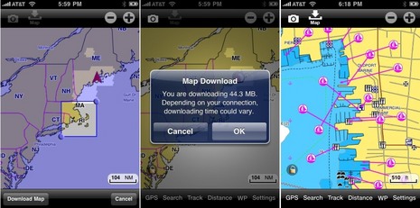
I think it's safe to presume that Navionics Mobile Marine is the best selling iPhone charting app in the U.S. and many other countries.  In fact, as I just wrote in an April Yachting article, many iPhone boaters consider it a "no brainer" even if they also use other nav apps. But lookee here, they've rebuilt the entire thing, substantially improving both features and value. Today you can buy the US East Marine and East Lakes versions for $10 each, a steal really, but they are 166 and 535 megabyte files, which is a bit of an inefficient pain for all concerned.  By contrast, the new $10 Marine&Lakes:US will be an easily updated 2 MB because it doesn't come with data.  BUT you'll be able to download charts and lake maps for anywhere in the entire U.S., quite easily, and fresh direct from Navionics' own servers. The greedy download illustrated above -- note the chart and POI detail of Newport -- took about 10 minutes via my home WiFi network, and a much smaller download went fine even over AT&T's poky Edge service.  And there's more...

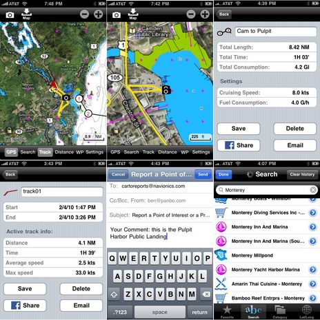
The new Navionics Marine is integrated with the Google Maps app built into iPhones, which means that, if desired, you can have the water detail overlaid on satellite photo maps, street maps, or a hybrid of the two.  And you will so desire.  I have a late stage Beta version here, but it still seems faster than the original even with maximum land data enabled. Click on the collage below and start with the upper two screens. First you'll see the phenomenal amount of integrated land, sea, and lake data I now have in my pocket.  You'll also see that I've been giving the app a workout (without even a beta burp).  I tracked myself driving down to the Public Landing where I took a few photos, then finger tapped a route to Pulpit Harbor (though routes are mainly just useful for distance and fuel estimates), and then emailed both it and the track, photo thumbnails included, to myself.  (You can download the Google Earth .kmz files here and here.)  I also reported a couple of little chart discrepencies to Navionics (will the corrections show up on the phone eventually?), and then used the POI search feature to poke around Monterey, CA, where -- what the heck -- I downloaded some more charts.
    Navionics Marine will only include lakes in the U.S. and Canada ($15 gets everything for both those countries, by the way) but foreign regions will also be greatly expanded without added cost. For instance, Marine:Carib & S. America will be $20, Europe 15�, UK & Holland 25�, Denmark & Greenland 40� (higher hydrographic fees, I think), and Australasia & Africa 20�.  I'm not sure how much coverage detail there is in those regions, but what is now almost 30 Navionics Mobile Marine regions will become just those seven.  And get this: Largely in the deference to the current owners of those 30 regions, which will be updated one more time and then discontinued, there will be a few-week-long introductory sale of the new apps.  Like $3 for U.S., $5 for Canada added, 5� for Europe, etc.  Can you say "no brainer"?

Navionics_Marine_USA2_cPanbo.JPG

Comments

PS. The new Navionics apps will debut in Miami next week, and may get through the iTunes review process in two weeks or so.

Posted by: Ben E at February 4, 2010 10:14 PM | Reply

The same larger Navionics regions are coming to iNavX and MacENC via x-traverse. Already the new 1G (US Waters, 3G (Caribbean, Central and South America) and 2010 Hotmaps are available for US$14.99 (Mobile editions). More larger regions coming online very shortly.

Posted by: GPSNavX at February 4, 2010 11:25 PM | Reply

Neat. MadMariner just introduced MadApp for easy access to much of its content:

http://www.madmariner.com/madapp

Posted by: Ben E at February 5, 2010 11:40 AM | Reply

I like this app. Have been using it on the Chesapeake Bay. Looking forward to testing the new version and see how it responds with the Magellan mount built in GPS. -Doug

Posted by: MaineFog at February 5, 2010 8:02 PM | Reply

Will it work with a bluetooth GPS receiver for precision location? Can't find anything on their website...

Posted by: Perry at February 6, 2010 4:35 PM | Reply

Apple has not enabled Bluetooth GPS on the iPhone or the iPod Touch, which is annoying and extremely annoying respectively. But if you're willing to jailbreak, see roqyGPS.

http://www.roqy-bluetooth.net/wp/

Other ways to get precision GPS to apps include the Magellan car kit

http://www.magellangps.com/iphone/iphoneapp_car_kit.asp

and the Dual Cradle

http://gpscradle.dualav.com/index.html

Posted by: Ben E at February 7, 2010 9:13 AM | Reply

Hey!

I'm using a Navionics chart on my iNavX app. Am I missing something? Does Navionics have its own charting app?

Posted by: Beauly at February 11, 2010 9:53 PM | Reply

How did you get to show Google Earth on the app? I have the latest version and I can't see it.
Thanks
Baz

Posted by: Bazz at February 15, 2010 12:18 PM | Reply

Google Earth?? Is that just in the beta version you got to use Ben? Inquiring minds want to know... right Baz???


Jess

Posted by: Beauly at February 15, 2010 2:00 PM | Reply

Yes, this entry is all about a completely rebuilt version of Navionics Mobile that I'm using in Beta, but should be available at the App store very soon. Current Navionics Mobile users will have to purchase a new app, it's not just an update, but the introductory prices will be very low for that reason.

Posted by: Ben E at February 15, 2010 2:37 PM | Reply

Will there be an easy way to transfer over existing waypoints, tracks, and routes to the NEW Navionics application(s) from the older applications?

Posted by: GPSNavX at February 15, 2010 2:50 PM | Reply

Hi Ben,

Do you have any more info as to when the new navionics app is out?

been checking the app store but seen nothing yet ?

Cheers,

Andy

Posted by: Andy Murray at March 4, 2010 7:27 PM | Reply

Hi Andy, Apparently there's been a snag with the new app. Allowing users to download charts directly from Navionics meant reformatting their whole database, and something's not working just right (though I haven't seen any problems).

The length of the delay is unknown but in the interim Navionics is going to update the existing apps -- the ones bundled with charts -- with the Google overlay feature.

Posted by: Ben E at March 5, 2010 12:46 PM | Reply

FYI Navionics V4 have been released in Europe's app store includes the google maps / pics overlay.

Regards,

Andy

Posted by: Andy Murray at April 2, 2010 2:29 PM | Reply

Do the Navionics Mobile updates include the new 2010 Gold Charts?

Posted by: GPSNavX at April 2, 2010 4:17 PM | Reply

Geocore is 00.01.16

They look very much like the 2010 charts i just put on Navnet 3d so i would guess so.

I dont have a 2010 'pure' navionics chart to test with.

Regards
Andy

Posted by: Andy Murray at April 2, 2010 6:54 PM | Reply

The new Navionics US East and Lakes East is in the apps store now, Andy (and all). It looks good, too, I think.

But I can't tell anything about how current the data is (Navionics is generally uninformative about this, especially as compared to C-Map). Where did you find that Geocore #, Andy?

I have both V4 US East and the still unreleased beta app, which downloads directly from Navionics servers, loaded on an iPhone. If anyone knows about a specific data update, I can compare. The beta app, incidentally, let's you register with Navionics and get notices about data changes in areas you've downloaded.

Also, I'm in Boston, staying about two blocks from the Apple store where iPad crazies have been camped out all night. With a little luck, I may get to touch one! Congratulations, GPSNavX for having an iPad app ready to go!

Posted by: Ben E at April 3, 2010 9:29 AM | Reply

Hi Ben,

Settings, scroll down to about and that page gave me the geocore below the program version number.

Regards,
Andy

Posted by: Andy Murray at April 3, 2010 10:39 AM | Reply

Right! Both Navionics Mobile V4 and V1 of the new app show the same "Geocore" 00.01.16. Whatever that means? In fact, both apps look very similar now, except that with the beta I can download any U.S. charts or lake maps.

Posted by: Ben E at April 3, 2010 12:05 PM | Reply

If a Navionics chart is downloaded to an IPAD is it FULL SCREEN or the same size as on an iphone?

Posted by: Robin Atkinson at April 4, 2010 12:27 PM | Reply

Almost all iPhone apps can run on an iPad, either in an iPhone screen size window or full screen using "pixel doubling". The few I tried in Boston did not look great. Examples here:

http://gizmodo.com/5508853/why-you-shouldnt-bother-with-the-ipads-iphone-app-upscaling

I suspect that charts will look especially bad with pixel doubling. It seems like most all the charting app developers are building iPad versions, as seen above, but Navionics has not yet spoken about this. And it may be a problem for them as I imagine they don't want to compete with the partner companies that display Navionics card data on similar size screens. Maybe Navionics iPad product will be a planning program, not a plotting one?

Posted by: Ben E at April 4, 2010 5:57 PM | Reply

Thanks Ben. A comprehensive and professional description of the status quo. Robin.

Posted by: Robin Atkinson at April 5, 2010 6:23 AM | Reply

'not sure how much coverage there is in those regions!' - well Ben, you'll be pleased to hear that once the canoe finishes the big mapping trip around Australia and we have finally get the water wheel up and running we'll have all we need to display some fine maps on them new-fangled iphones. Not as good as our well-educated and geo-politically aware friends in the USA of course, but not too bad for a bunch of savages.

Darwin, Australia

Posted by: And we can even read too! at April 16, 2010 2:56 AM | Reply

Context, Darwin, context! I'm quite sure that the Australian Hydrographic Service maintains quality charts for your entire coast line. What I am not sure of is if Navionics has transformed all of that data into its own electronic chart format. I'm especially not sure that Navionics has data from every hydrographic office in all of a region as large and varied as, say, "Australasia & Africa". If you still think I'm slighting your country, you need more reading practice!

Seriously, people need to realize that converting HO chart data to commercial electronic forms is not a trivial undertaking. Companies like Navionics, C-Map, Navico, and Garmin often have to trace paper charts to get them into vector format. Plus they have to negotiate licensing agreements with most nations (only a few are copyright free, like the U.S.), and then they have to constantly monitor and apply HO chart changes.

In short, when you buy a large chart region, do not presume that you're going to get every chart in that region. Most manufacturers have Web pages where they detail actual coverage.

But the whole process is getting easier now that many countries are converting their own charts into ENC vector formats. But Australia, like the U.S., has not finished the big portfolio conversion job yet:

http://www.hydro.gov.au/seafarer/enc/enc.htm

Posted by: Ben E at April 16, 2010 7:09 AM | Reply

Hi :

I just updated both my Navionics BC , Canada and Navionics , Australia to the latest Version 4.1 and there was no update charge!
Or is this an interim update?

And yes..one can view the shoals ( and the 'salties' basking on Angler Reef too mate!) in Shoal Bay, near Darwin, Oz.

Posted by: Paul Downie at April 27, 2010 7:07 PM | Reply

Apple has no mechanism to charge for an app update (i.e. new version of the same app). All updates are free of charge. Some apps do support in app purchases (i.e. for new data), but so far this is not occurring in the marine navigation category. Some developers are choosing not to natively support iPad with existing apps, but to release new iPad specific versions and charge for these.

Posted by: GPSNavX at April 27, 2010 9:26 PM | Reply

BUYER BEWARE. The app wouldn't install on my Motorola Droid (would hang on authorizing payment) even though the charge came through Google Checkout. Navionics customer support is atrocious and they say they cannot refund my charge!

Posted by: Ryan at July 22, 2010 11:45 AM | Reply

This app is now available for the Android. I just downloaded and should try it out this weekend. But what are the pink chickens all over the map? You can see them on the top middle on your second set of screenshots.

Posted by: mickey at August 26, 2010 10:08 AM | Reply

The "Pink Chickens" are Navionics method of denoting an Ecological preserve.

Posted by: Bob Etter at August 28, 2010 9:30 AM | Reply

addendum...

The NOAA ENCs designate the "Pink Chicken" portions of the chart as No Discharge Zones.

Posted by: Bob Etter at August 28, 2010 10:05 AM | Reply

Thanks, Bob.
I can see some type of preserve. I'll do some more digging on that. However this area is not a "no discharge zone". There is only one on the MD portion of the Chesapeake. I also have never seen the pink chickens in NOAA ENCs. I'll look again.

Posted by: mickey at August 28, 2010 11:29 PM | Reply

Yup, I posted that too fast....I was sitting in Oyster Bay, NY and it is filled with Pink Chickens, queried tne ENC for that location and it was SPECIFIC as to the nature of the designation there, I would guess that the "Ecological Preserve" label on the Navionics charts is a general designation for locations that would fall under that definition, No Discharge Zones, for example.

I would bet the area around the Florida Keys is probably one of the biggest Pink Chicken Farms around and has numerous designations official chart designations (no discharge, no anchoring, etc., etc.). Navionics just chooses to cover 'em all with the Pink Chicken?

Posted by: Bob Etter in reply to mickey at August 30, 2010 12:53 PM | Reply

Leave a comment