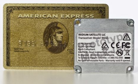
The smaller, cheaper Iridium short-burst data (SBD) modem I heard about at Fort Lauderdale is now official and, wow, doesn't it look able to "disappear into as many marine devices as possible!" It even has GPS input/output ports so that it and the modem can easily share a dual-mode antenna. Hardware and service costs aren't specified but Iridium is claiming that the 9602 will have "the highest value in the industry." I, for one, can't wait to see devices like the Spot Messenger that are global and bi-directional, not to mention what the MFD and marine security/tracking developers might do with the 9602. And I'm glad for Iridium that it's got this and OpenPort going on, because it sure looks like Inmarsat is finally about to attack its dominance in the portable satellite phone department...
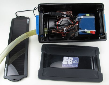
Weird world that it is, I first learned of EasyBailer via Twitter, even though the "factory" is just down the coast. Last week I stopped in and met "CEO" John Bianchi in his shop full of small boats, including an impressive plank-on-frame Rangeley Guideboat he built himself. Thus I wasn't surprised to see how neatly put together his solar-powered dinghy pump is (click above for detail). And I consider myself somewhat expert on this subject as I tried to assemble a similar system myself with poor results...
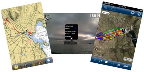
The tidal wave of interesting iPhone boating apps rolls on! The screen at left above (click for bigger) shows a beta version of Memory Map's upcoming charting app and I can tell you that it already handles NOAA raster charts and topo maps with speed and smoothness I didn't think possible on plain 3G hardware. At middle is the brand new Ships Ahoy!, a $3 AR (augmented reality) relative to Ship Finder and the other AIS viewers that lets you just point an iPhone 3Gs (you need the compass) toward a vessel or two to get their names and details (if the area is covered by a network receiver). And finally there's Navionics' neat new Ski:US, which admittedly has nothing to do with boats but does speak to this big marine company's big commitment to mobile apps. It happens to have my local Camden Snow Bowl among the so-far-limited ski area coverage, and it works great. In that screen shot I'm playing back the tracks (in yellow) I cut right after last week's big snow dump, in particular the --- MPH moment I lost board control in a huge drift. All these possibilities, and lord knows what else, will expand if Apple introduces a 4.0 version of the iPhone operating system this afternoon. But of course the bigger questions swirl around the Apple tablet, or whatever they decide to call it...
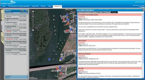
My longtime admiration for Jeff and Karen Siegel, and their creation ActiveCaptain, has started to lean dangerously toward jealousy! They've spend many months cruising from Maine to Florida and judging from their blog and the latest AC newsletter, they've not only been having fun but also writing code and making deals the whole way. Version "X" of the interactive cruising guide is really taking shape, and other developments coming soon do indeed sound "huge"...
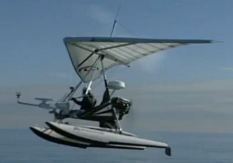
Good grief! It was plain as day that this America's Cup was going to be all about technology (and bad mojo), but a pair of wind-seeking microlights equipped at minimum with anemometer, satellite compass, and radar? I can't find any info about the Alinghi Air Force on the team's own site, but Sailing Anarchy has the tape, and some trenchant commentary. If any of you can find out more on that electronics set up -- or, even better, what's on the boats -- please let us know. Meanwhile, I'm lining up the resources I'll use to monitor this madness in progress...
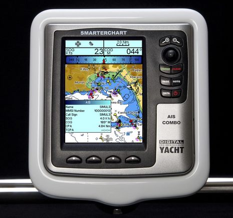
As noted recently Digital Yacht is on a new product roll. To my knowledge this SmarterChart SC500A is the first new C-Map plotter in quite a while, and the first plotter to have a built-in AIS receiver period . At $799 list, it might be just the thing for open helms on some smaller boats, for which DY also has a new line of helm pods (though they don't seem to be online yet). But some bigger boats might want one of these to serve mainly as an AIS target plotter (it has NMEA 0183 output too), and there are a couple of other interesting developements in that department...
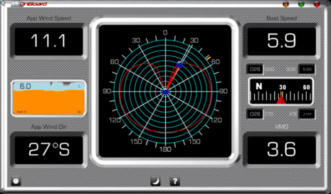
I've recently been beta testing a suite of software products from a marine electronics newcomer called Avia Design, and I'm tentatively enthusiastic. They are the first products I know of that are fully leveraged off the NMEA 2000 Third Party Gateway (TPG) discussed yesterday, and therefore a sign of many things to come (I think). And they're cool, or at least should be when finished. Check out that real time polar diagram for performance sailors above -- I'm not sure there's ever been one before -- and there's plenty of power boaters too...
I've got a large NMEA 2000 network set up in the lab now, and it's giving me a good chance to try out the Actisense NGT-1. It's fully NMEA certified now, and selling for $200 at some outlets, but I gather that the Third Party Gateway system (formerly known as the Intelligent Gateway) of which it's a part is not yet fully detailed. In other words, we don't quite know yet how software that works with it will get NMEA approved and what, if any, restrictions there may be on how it's sold. For instance, bundling in an NGT-1, or a similar gateway, may required. But I can tell you this: Beta versions of TPG software are starting to look powerful...
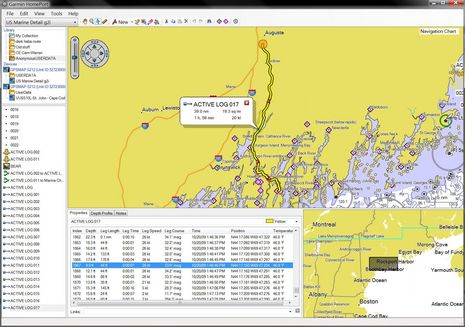
I can't imagine why anyone with a Garmin plotter, a Windows PC, and a bit of ability to use both wouldn't find Garmin Homeport more than worth the $30 charge. I was able to easily copy the 5212's embedded charts -- plus the mess of tracks, routes, and waypoints I put on it last season -- and then review/manage all on my home computer. I stowed away some memorable tracks, quickly cleaned up some extraneous waypoints (careful with that track-to-route feature), polished some favorite routes, and then overwrote the user data on the 5212 with a much more useful set. But today's look at some deeper Homeport features gets the benefit of a friend's embarrassing navigation error. Click to enlarge the screen above and I'll explain after the break...
The concept is pretty sensational: The ARGUS (Autonomous Remote Global Underwater Surveillance) system would equip volunteer vessels with a custom WiFi transceiver that is connected to the nav system for GPS and depth, and that can automatically upload the resulting data files (when possible) to a shore server where it's collated and quality controlled before being turned over to NOAA so it can better manage its dredging and charting responsibilities. If it all works out as hoped, the volunteers might even get the equipment for free and be able to use the WiFi connection for their own Internet needs...


