I know a lot of salts, some of them geeks too, who've been using The CAPN for years, and don’t want to switch. I’ll bet they’ll be pleased to learn that this venerable charting software package will now be managed and developed by new owner Star Technologies, as announced here. I had a long chat with principals Bob Strunce and Witt Wittmaack today, and was impressed with what a good home this looks to be. For one thing, Star Technologies really is about rocket science, better yet the software side of it, and has been for some 30 years. For another, Strunce is a serious boater who’s been using The CAPN since 1993, and Wittmaack is Naval Academy graduate with time on submarines. Here’s what they have in mind for The CAPN:
Here’s some follow up on Russ Cooper, the Panbot who recently commented that he’s “spent >$10,000 to get an N2K coolant water pressure gauge that works...and still doesn't have one!” Ouch. He has a legitimate gripe, I think, though I doubt the problem is unique to Garmin. You see Russ bought a Bennington 2275RLi with a Yamaha 150 that he’s using on a particularly weedy lake in Ontario. Whereas the Yamaha is sort of NMEA 2000 compliant, he put together the nifty system you can see above (bigger here) and diagramed below. But—cue the Rolling Stones here—you can’t always get what you want, as Russ explains:
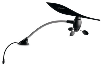
It’s a good day here when the sun is shining invitingly and a noteworthy, yet easy to write about, new product is introduced. So a Panbo thanks to Garmin for the new GWS 10 wind and weather sensor, bigger image here. What with NMEA 2000 proliferating widely, it seems a little strange that this might be the first standard whirligig (i.e. electro-mechanical) wind sensor with a standard N2K plug on it, but I’m pretty sure it is. Yet, as you’ll find in the press release, it also has air temp and barometric pressure sensors like Maretron’s WSO100 ultrasonic wind sensor and Airmar’s do-it-all PB200 (that I wrote about in August, but apparently still not quite shipping).
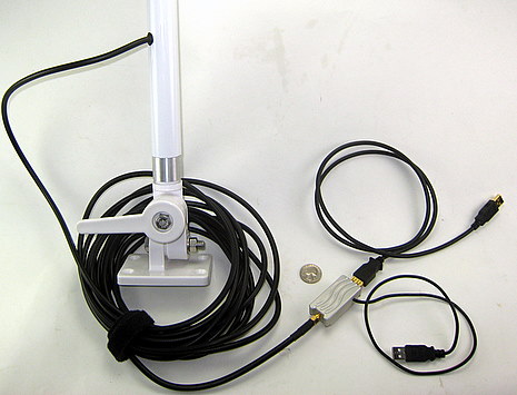
So I’ve been testing two marine WiFi systems. First up is newcomer 5MileWiFi, pictured above. Its heart is in that little machined aluminum case which delivers Internet to your PC via that main USB cable, also used to get some of the power needed to run what’s claimed to be a 1,000 mW WiFi transceiver. The side mounted USB cable is just for added power and can go to your PC or any other USB power source. The $399 package also includes 25’ of LMR240 coax and a 38” high 9 dbi omni-directional marine WiFi antenna.
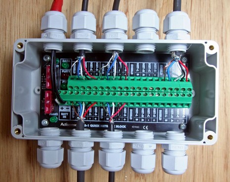
I used Actisense’s QNB-1 Quick Network Block, above and bigger here, to create Gizmo’s little NMEA 2000 network, and it pretty much lived up to expectations. While using regular tees and fixed cable lengths would have been messy in the small confines of my console, this junction box let me cut cables to length and still end up with a fairly waterproof system. The built-in fuses and LED status lights made the install easier, and those cable glands provide good strain relief on a variety of cable sizes (add Tommy Tape when they don’t). But I must say that fixing wires to the terminal strips can be tedious, and downright hard in tight quarters (I did most of the wiring on a bench).
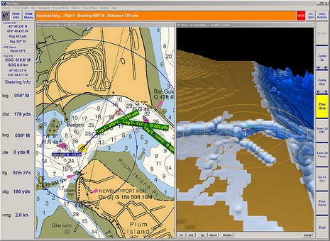
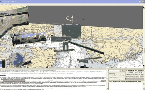
(Psssst!…back at work but need a little distraction, preferably for a good cause?) The screen shot above is worth seeing full size, but even then doesn’t do justice to the highly dynamic GeoCoastPilot beta program I’ve been entranced with for the last hour or so. The concept is an interactive 3D map that integrates official NOAA Coast Pilot textual information with vector and raster charts, bathy data, and panoramic photographs of key features. In this particular scene I clicked on the Portsmouth Harbor Channel Lighted Range link and the program lined up and highlighted a picture that might make it much easier to actually see the marks. When I then use the screen gizmo above the photo to tilt or turn the scene the photo changes if there are multiple shots available. There’s much more to it, as suggested by the choices at lower right, and for beta software, it seems to work pretty well. If you have a PC running XP or 2000, you go the GeoCoastPilot site and try it yourself, and you should!
I can tell you with some certainty that an RSSI value of -106 usually shows as one tiny bar on my Verizon Centro phone and usually means that it can ring when called but is darn flaky in terms of actual verbal communication. It’s pretty much the standard Verizon cell status around my house and even most places right outside. What I can’t tell you is whether the Cell Ranger Stix amplifier I’m testing was on or off when I took this photo…because it seemed to have no effect on the signal whatsoever!
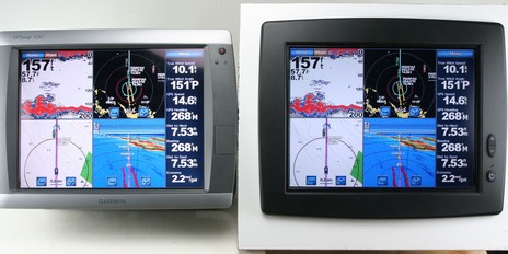
Well, I’m impressed, and you may be too when you check out the bigger image. Repeating the image on that Garmin 5212 (via VGA cable) is a Planar LX1201PTI, one of the marine touchscreen family recently discussed. Both are turned up to max brightness and I did my best to balance the three photo lights arrayed around them. I think the Garmin 5000 Series has become the bench mark of bright touchscreen displays, and to my eye the LX is just a dite less bright, but has slightly more saturated and contrasty colors. The waterproof and reasonably priced LX also seems well made and is designed with multiple mounting options besides the surface mount I rigged (by snapping off the plastic bezel). Nice.
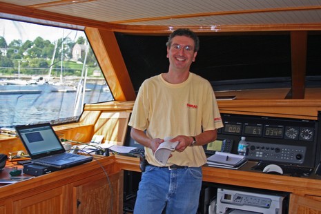
Big yacht IT is challenging, and thus I nearly had to tickle local marine networking ace Nik DeMaria (Blue Maple Systems) to capture his naturally grinning good nature, above and bigger here. I’ve known Nik “since he was knee high to a grasshopper,” as we say around here, but now he can make my head spin with talk of stuff like static IP addresses and Dynamic Host Configuration Protocol (DHCP)—his worries last week. You see, he and John Gass were just wrapping up the installation of a KVH V7 mini-VSAT aboard the 115’ sailing yacht Tenacious, and while they termed that chore “easy”—even pulled it off in less than a day—Nik was looking for an elegant way to manage the vessel’s multiple Internet users and sources. I think he’s still looking, and maybe some of you Panbo-reading IT types can help…
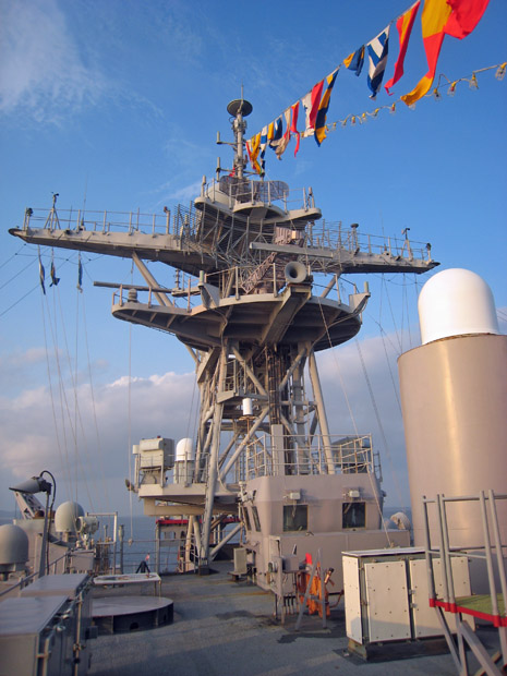
Now that, friends, is an antenna mast (bigger image here). By way of scale, the tubular frame radar array showing over the large horn is 24 feet wide. I also learned that while the crew of the USS Whidbey Island does get “slow” Internet access underway, it doesn’t work on some headings, which suggests that whichever dome delivers recreational Internet may sometimes be in the shadow of that huge mast. This 609’ LSD (dock landing ship) was here to celebrate Windjammer Weekend, and I lucked into a tour led by a cheerful Ensign in the “Electro” department. Details of interest: