Garmin GWS 10, N2K weather whirly

... written for Panbo by Ben Ellison and posted on Sep 12, 2008

Garmin_GWS10

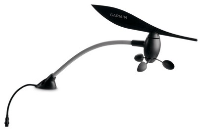
It’s a good day here when the sun is shining invitingly and a noteworthy, yet easy to write about, new product is introduced. So a Panbo thanks to Garmin for the new GWS 10 wind and weather sensor, bigger image here. What with NMEA 2000 proliferating widely, it seems a little strange that this might be the first standard whirligig (i.e. electro-mechanical) wind sensor with a standard N2K plug on it, but I’m pretty sure it is. Yet, as you’ll find in the press release, it also has air temp and barometric pressure sensors like Maretron’s WSO100 ultrasonic wind sensor and Airmar’s do-it-all PB200 (that I wrote about in August, but apparently still not quite shipping).

Alternative ways to get wind data onto a NMEA 2000 backbone include Furuno’s new analog whirly, but it has to cable separately to one the FI-50 wind instruments; or most any Raymarine whirly, but you’ll have to deal with an STng Wind Pod and non-standard cables; or a Simrad whirly, which is a true NMEA 2000 smart sensor, but again using a non-standard cable design. My sense is that when you calculate all the install and hardware costs, this Garmin system is going to look pretty good. Of course there are many details—like performance—that we won’t know without some field testing (which I hope to do).
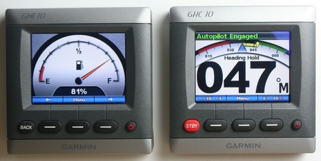
   One important detail that’s predictable, at least at this point, is that you’ll need a Garmin GMI instrument or 4/5000 MFD to calibrate the GWS 10. The company hasn’t revealed wind instrument screens yet, but there’s reason to believe they’ll look very nice. Check out the heading/speed screen shown when the GMIs were introduced last fall, and the speed screen with optional max and average markers I set up in March (I hope the next GMI firmware update makes using such screens more flexible). And here are two more for your viewing pleasure, bigger here. Remember from the press release that Garmin’s shaded digital wind needle is going to move with 10Hz smoothness, and, yes, that’s their new autopilot head, or at least a beta version in simulation mode down in the lab. But I’ve been on the water with the whole and almost done (Oct. 1 they’re saying now) GHP system, and it’s cool. More to come. 

Garmin_GMI_10_GHC_10_lr_cPanbo

Comments

The value of standards is magnified in the marine space, where the indirect costs of a purchase are so high.

Given the choice of another set of connectors and a converter box or going straight to N2K, the latter is the obvious solution. Garmin, with little to lose in this space, is obviously going to chase this... Apparently the others are much more reluctant.

Posted by: john d at September 12, 2008 1:52 AM | Reply

Ben et al;

I like the Airmar PB200 weather station features & promised functionality - but have a question for the sailors in the audience. If I use the Airmar PB200 for my sailboat, would you as well use a conventional wind direction/wind speed indicator at the mast top? If so why? Thanks for the feedback.

Mike

Posted by: Mike at September 12, 2008 4:03 AM | Reply

We are on our second Simrad masthead unit (which is NMEA 2000, but called "Simnet"). I am less than impressed with it's durability... Hopefully Garmin will do this better.

The ultrasonic approach looks great to me (no moving parts) but I am waiting to see more boats adopting them.

Posted by: Phil Koken at September 12, 2008 9:15 AM | Reply

Mike ... are you asking if you should keep a conventional (unwired) direction indicator at the top of your mast or a conventional (wired) speed and direction indicator at the top of your mast ?

Posted by: Dan (b393capt) at September 12, 2008 9:47 AM | Reply

I was asking if I should keep a wired conventional speed/direction indicator at the top of the mast. If I switch to an NMEA2000 based system compatible with the new airmar weather station - is there any reason why I should keep the current speed/direction indicator wired as a back-up? That is assuming that it could be - forgive my ignornace here!

Posted by: Mike at September 12, 2008 10:05 AM | Reply

Rodney Dangerfield is alive and well in the Garmin Copy-writer department:"The art of windage made simple." Sheeesh! Please: would a SAILOR at Garmin have a few brief words with the copy writers?

Posted by: Sandy at September 12, 2008 10:58 AM | Reply

Ben, does the new autopilot head display rudder position when the autopilot is not engaged?
Doug

Posted by: MaineFog at September 12, 2008 11:10 AM | Reply

No, foggy, there's no rudder position display, at least in the Beta software I've seen. This autopilot, like the old Nautamatic TR-1 gear it's based on, does not need and does not come with a rudder angle sensor. However, I think Garmin knows that lots of skippers want to know what their rudder(s) are up to and I wouldn't be surprised to see it added to this display.

Sandy, I wasn going to let that slide, but you're right; that's an odd expression. For more inadvertent humor, check out some of the blogs that cover Garmin obsessively but aren't too up on boat stuff, like:

http://tinyurl.com/3oy7r3

Posted by: Ben at September 12, 2008 4:41 PM | Reply

Mike,

If I get your meaning, you're wondering if you can rely entirely upon the N2K network or should you keep some sort of mechanical backup. If that's not what you're asking, forgive me.

I recently converted all of my gauges (pontoon) to electronic.

1st mistake was in thinking that I'd have all the displays I'd want. Despite the fact that my Yamaha ECU puts out lots of details, my choice of Garmin 4212 as an MFD proved less than I hoped. Namely, my coolant water pressure/temperature values had nowhere to display on the Garmin. To fix this I had to purchase a Yamaha electronic gauge, that displays that information in a less than useful graph (as in, the first bar on the graph can equal ok at idle, or, no pressure due to a tell-tale blockage...um, thanks!)

Back to your question. What I realized was that I wasn't able to find out ahead of time precisely what I was going to get displayed on my MFD, and as a result, didn't get what I wanted. Garmin listed the requisite N2K PGN, but they don't support display of all possible fields within that PGN. If you don't know what I mean, read an N2K fundementals somewhere (Maretron, for example.)

IOWs, there might be some nuance or actual fact you get from your mechanical systems that aren't displayed (or displayed in as useful a fashion) on your N2K device. This is major suckage in the N2K adoption arena, if you ask me...but maybe everyone who test these things are using them the same way...so they never realize what's missing. Ben??

So, before you rip out your mechanicals, I'd strongly suggest you read a review somewhere that covers every detail you might want out of a system. If they don't mention it, assume its not available, and then ask yourself if it matters. Whatever you do, don't rely on N2K PGNs as suggesting you'll get all the fields they say are in the PGN. At this point I think Maretron is the only one that accomodates display of all fields.

Finally, make an important note of Ben's comment about calibrating the unit. While N2K offers the concept of anyone sending any settings to any N2K device...the reality of this is probably going to be it's demise. Why am I, as Vendor X, going to allocate programmer time to fixing issues sending settings to a non-Vendor X device (when, typically, the problem is with the non-Vendor X device accepting properly formatted packets.) In case you weren't around for this fun, we had all of this with TCP/IP stacks for PCs back in the early to mid 90's. There are far fewer purchasers of N2K boating equipment than there was/is PC stuff...so expect this sham to go on for a long time.

Bottom line is to buy N2K stuff with a good refund policy, and expect to right off the installation costs to goodwill or pure folly. In any event, don't remove your mechanical until you've assured yourself the electronics will give you everything you had.

Cheers,
Russ (who spent >$10,000 to get an N2K coolant water pressure gauge that works...and still doesn't have one!)

Posted by: Russ Cooper at September 12, 2008 5:14 PM | Reply

Gargling; to giggle at Garmin. For example, read this aloud, as if you're a TV announcer:

"When combined with other sensors, the GWS 10 provides those on board the ability to gather specific wind data such as ground and true winds, wind VMG and tack heading."

Can't keep a straight face, can you?

Posted by: Sandy at September 12, 2008 11:01 PM | Reply

I bought a Raymarine ST 40 Windspeed indicator and Rotaveta sensor for under $300 when on sale at Defender with $30 rebate. It can be used alone or added to the Raymarine Network. The "weather" and GPS portions of the more expensive systems don't seem to add much to me except cost and reduced reliability.

My needs are simple - weather comes from VHF WX channels and not from me tracking the barometer in coastal areas of the PNW. The most important detail to me is wind trending - am I seeing rising or falling winds, what peak gusts and direction? For anchoring and for choice of heading for cover - thats all I need. I'd want a full wx station to go offshore - but thats not in our cards.

Posted by: DaveV at September 13, 2008 2:01 AM | Reply

Mike: If you're asking whether the PB200 is accurate enough for sailing, that's what I'd like to know as well. I considered it, and others, but have been unable to find any information about wind direction accuracy. I suspect it cannot replicate the accuracy of a wind wand, but I can't find any hard data. And when reading the spec, they are somewhat ambiguous. They quote 1.5 degree sensitivity and .1 degree resolution, but that says nothing about accuracy.

With regard to Garmin, and most other vendors, I agree that cabling is only the first step to interoperability and are now using calibration to try to prevent multi-vendor installation. Vendors seem to be moving to interoperability in the most painfully small baby steps. VENDORS - Calibration of your sensor is not VALUE ADD!

My only on board experience in N2K calibration is that Furuno will calibrate an Airmar depth/speed/temp transducer, but Maretron's DSM250 will not.

Posted by: Anonymous at September 13, 2008 9:55 AM | Reply

Oh yeah! I have been holding off on a wind transducer, as the Simrad seemed to be the only one that would work for me. I got a GMI 10 already installed, thanks to a very nice price from West Marine. So this is going to be the one. And it looks like the mounting will work better for our masthead then the Simrad transducer to boot.

I seriously considered the Maretron, but with a masthead trianchor light, there is no good way to mount the thing. Shame they don't work with Orca Green or the like to make a specific mount that will not obstruct the light.

Back to the Garmin wind thingy. My only concern is that it can be calibrated with the GMI10. I am not at the boat right now, but I don't recall any screens for such. Maybe they are activated if the GMI10 sees the transducer. Or more likely, a Firmware upgrade will be needed. Garmin, if you are reading this, how about adding an Anchor alarm while you are at it, and making the DC voltage alarm useful!

Chris

Posted by: Chris Witzgall at September 14, 2008 12:33 PM | Reply

Chris, There will definitely be a firmware update to the GMI10 to accommodate the wind/weather sensor. It will need to be connected via NMEA 2000 to a 4- or 5000 series MFD to get the update from SD card into the GMI.

Besides wind and weather screens, which must be coming, there are lots of improvements on my GMI wish list, like a depth graph and rudder angle indicator (numeric and graphic choices). Most of all, though, I they expand the "custom screens" options to include more pages and access to the fancy graphics seen above, and now only available when you select a pre-configured family of screens.

Posted by: Ben at September 14, 2008 2:12 PM | Reply

Ben;

I look forward to what Garmin does with the firmware upgrade. The upgrade method is going to be a bit of a PITA for those of us without one of those Garamin Chartplotters. Since my power cable is mounted on the boat, and I will not remove it, I'll either have to find a retailer with chartplotter and a GMI10 power cable, or a boat owner with the same setup as me. Or some combo of the above including the purchase of another power cable. UGH, Of course it would be easier if they had just powered the thing off of the network like everyone else's display. I guess you have to pay for that gorgeous LCD!

Chris

Posted by: Chris Witzgall at September 15, 2008 6:16 PM | Reply

Ben:

You mentioned Airmar's PB 200 wx station before, have you heard when it will be available? They are advertising it now but Defender does not know about it.

Any thoughts on compatibility with a Ray e80?
Raymarine said contact Airmar and Airmar says talk to Raymarine.

Thanks

Posted by: Bill at September 16, 2008 12:15 PM | Reply

Bill, I was just told by Airmar that the PB200 is now shipping. I suspect that your E80 will display its output well, as I've seen with Maretron's N2K Weather Station and Airmar's 0183 version:

http://tinyurl.com/3apm7a

Note, though, that Airmar is not 100% confident that the PB200 will perform well on a sailboat's masthead. They want to do more testing before they make that claim.

Posted by: Ben at September 16, 2008 3:07 PM | Reply

I'm just now getting into the multi-vendor interoperability issues, and some are real head-scratchers.

The latest is my old B&G h1000 network that came with the boat. Works fine. I used their universal interface box to convert Fastnet to 0183, then a Simrad AT10 to N2Kify that. Voila! Instant display on the Maretron DSM250 of wind, depth, and STW.

Only... the B&G stuff insists on transmitting the variation, even though it has no compass. Every 2-3 seconds, when that system is on and the AT10 enabled, my compass display glitches -18 degrees and back again. Naturally, the autopilot finds this most amusing.

Speaking of the Autopilot (Simrad AP42), it is a major pain. When it works, it's great, but it can take over an hour to convince it to come out of Standby and not say "Change Denied" on the remote (a message not in their manual). The user interface is clunky and counter-intuitive, and the setup is so arcane that it is not at all obvious what it's using for heading data... though once it comes online, steering is steady and the remote very convenient.

I love the concept of N2K, and some of the devices are trouble-free... but it's definitely life on the bleeding edge. But when navigating in the fog, that's not where I really want to be; it's edgy enough already.

Steve
http://www.nomadness.com/blog
currently here: http://map.findu.com/n4rve

Posted by: Microship at September 17, 2008 11:29 AM | Reply

Steve,

This is one of the areas where you can get into a debate regarding what should be part of the standard, and what is a Vendor difference.

I've seen comments from some people who claim that this device or that can be set to have a preference, when confronted with information from multiple sources (and, presumably, even when confronted with information from a single source, as in ignore or accept.)

The best way, IMO, such things should be handled is by giving every N2K device a USB port (a male port, as in I'm a device that can plug into a computer, not the Maretron USB100 type.) You take the device to your PC and plug it in, and you are then able to configure what it will send and what it will receive...voila!

If you're not an MFD, how are you expecting people to set you? Typically, today, the vendor is expecting you to purchase their MFD because they're often the only thing on the planet that can set their devices.

Not only is this a way to prevent interoperability (or enforce vendor lock-in), but it is also a way to avoid network congestion (or just plain bad choices, like you mentioned with your auto-pilot.) You put a complex network together and it won't surprise me if you'll start to see latency issues that could be crucial.

When I put my boat away for the season I am planning on pulling out all of the electronics and setting them up in the house so I can plug in my PC see what I can see, and hopefully, do. It shouldn't be hard to cobble together a sniffer (maybe the Maretron N2KAnalyzer already is?) that can also send packets (so as to configure stuff.)

Of course then the problem becomes whether the devices keep their settings (probably not) or even accept being set (again, probably not.)

Sometimes two cans and a piece of string look darn attractive...;-]

Cheers,
Russ

Posted by: Russ Cooper at September 17, 2008 2:27 PM | Reply

The new Garmin Wind instrument looks intriguing.
One issue I have is the masthead unit does not look like it is easly removed. In the fall in New England we generally remove the mast head device to prevent ice damage.
Most other units have the wind sensor shaft plug into a connector attached to the top of the mast for easy removal. This looks like a major drawback for us northern sailors.

Posted by: Robert Lee at October 17, 2008 11:36 AM | Reply

Good point, Robert; and I actually saw a sample at NMEA but didn't notice if it is removable. Doh!

But I did check out the wind screens Garmin has created for the GMI instrument and they looked great. If you want, the standard needle and 360 degree wind rose can automatically become a close hauled gauge when you are close hauled, or a downwind gauge when you're sailing very deep. Even the up and down wind scales are adjustable.

Some sailors, though, are concerned about the GMI's backlighting. According to the spec it uses 2.5 watts max, but they add up.

Posted by: Ben at October 17, 2008 12:12 PM | Reply

GMI10 wind screens: "360 degree wind rose can automatically become a close hauled gauge when you are close hauled, or a downwind gauge when you're sailing very deep. Even the up and down wind scales are adjustable. " ... outstanding !

Posted by: Dan (b393capt) at October 17, 2008 12:51 PM | Reply

Garmin presonnels at Miami show told me the GWS10 and GMI 10 are NMEA183 and NMEA2000 compatible, in the brochure of Garmin i do not see any reference of NMEA183. I will like to confirm before to purchase the unit. My autopilot is a B&G H1000 NMEA183.

Posted by: Jean Claude Fontaine at September 1, 2009 9:05 PM | Reply

A 5 min search on garmin.com reveals that:

http://www8.garmin.com/manuals/GMI10_Installation.pdf page 6

"Connecting the GMI 10 through NMEA 0183
The GMI 10 can receive NMEA 0183 data from one device. The GMI 10 displays the received data, but cannot transmit the data to another NMEA 0183 device or transmit the data to a NMEA 2000 network."

So the answer is that you cannot use the GMI 10 or GWS 10 to send data to your auto-pilot. Also, the NMEA 0183 capabilities are very basic as there is no retransmission on N2K taking place.

Posted by: Kees at September 2, 2009 3:38 AM | Reply

Thanks, Kees. It's too bad that Garmin didn't build some NMEA 0183/2000 translation software into the GMI 10, but Jean Claude should know that such translators exist (from Simrad and Actisense) and would let him send NMEA 2000 wind and goto data to his B&G AP fine I think.

Also, more about how nicely the GMI 10 displays wind data from the GWS or other N2K sensor:

https://www.panbo.com/archives/2009/03/garmin_gws_10_hands_on_2.html

Posted by: Ben E at September 2, 2009 9:15 AM | Reply

We were in Hurricane O'dile in Cabo San Lucas Mexico. Max wind speed was probably around 175 knots. Our indicator was blown off the boat. The after market mounting hardware survived. Does anyone know what the max wind speed these things are rated for? And the head unit is dead too. Do you think there is data in there recording the highest wind gust?

Posted by: Capt Gib Corwin at November 28, 2014 10:39 AM | Reply

Leave a comment