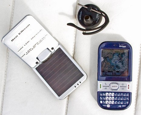
Good times: I spent most of yesterday testing electronics on Gizmo and visiting around Camden Harbor. One system I was mostly pleased with is this little wireless communications and navigation PAN (Personal Area Network), if I may apply a long name for what’s a fairly doable setup these days (bigger picture here). The Palm Centro is running ActiveCaptain Mobile and has the Region 101 raster portfolio loaded on its 1gb micro SD card. That’s a single 353 mg file containing all charts from the Canadian border to Block Island, which scale, zoom, and pan very quickly, and look good. Better than the photo(s) actually, if you put the Centro’s transflective screen in direct sunlight or use its full blast backlighting in heavy overcast conditions.
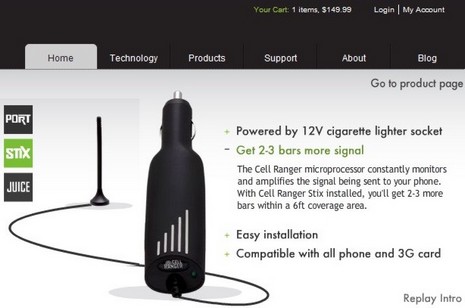
Thanks to John Forder for pointing out the intriquing Cell Ranger Stix wireless cell phone booster. It claims to use a microprocessor to analyze a cell signal coming in through its little antenna and then add 50 dB of gain (2–3 bars!) as it retransmits the signal in a six foot radius around that 12v lighter-plug-like casing, all for a $150 and nearly zero install effort. If true that would definitely be useful on many a boat, and maybe in my office where my recently acquired Verizon Centro is barely usable. In fact, using a “field test” code found at wpsantennas.com—field test numbers are more responsive, detailied, accurate than screen bars—I’ve learned that it has an RSSI of -105 (very, very poor), and an EVDO signal strength of 107 (meaning unknown, but should change with amplification).
Continuing yesterday’s ode to the Lowrance LCX-113, I’ll explain how I’ve been using it to test GPS sensors against each other. Every NMEA 2000 MFD and instrument I’ve tried can handle multiple GPS (and other sensor) inputs, which is good, but they do it with a variety of styles. Some—like Raymarine’s—just grab the first one they see coming down the backbone and use it, unless it pooches out and then they will use another if available (aka “roll over on failure”). Others, like Garmin’s and Simrad’s (NX models excepted), will pick one source automatically but will also let you choose from a list of redundant sources if desired. Lowrance, as I’ve discussed before, goes a little further, letting you use more than one redundant source at once. But Lowrance does something special with GPS, because those sensors send out Dilution of Precision (DOP) values based on the strength and breadth of satellites they’re locked onto.
So far this season, I’ve had two excellent, and very different, voyages of discovery aboard Gizmo, and the test Lowrance 113–LCX HD has been very useful for both. As shown earlier this month I’ve got it rigged to a small NMEA 2000 network, which feeds the LCX the output of at least two GPS receivers, a Lowrance EP60R fuel sensor, and a Maretron Weather Station, with many add-ons possible. Check out a bigger above image , showing Gizmo up a tidal tickle in Maquoit Bay, about as far into Casco Bay as a boat can go…if the tide is high! The LCX, using just the Skimmer transducer it comes with, had no trouble with these shallow readings, even at 20 knots (once I got confident that the immense mud flats are flat indeed). Notice too the 76 degree water temp, which I’ve never seen in Maine salt water and which partially accounts for the happy bird life in this new preserve.
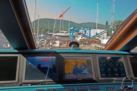
Binoculars, sminoculars! Open the bigger image to get a hint of how well Sandrine’sFLIR Voyager multi-camera system is bringing in the little tower on Mt. Battie (from which I took Panbo’s header photo). Live in person you could easily watch the tourists climbing around, and we didn’t have it totally zoomed in. But, egads, on Oct. 1 FLIR will offer a Voyager II model with some must-have features. For one thing, it will input radar cursor data and thus automatically hone in on selected targets, which could be very valuable, I think. It will also have an IP address, and thus will be remote controllable from any computer on the yacht or beyond, which could be fun.
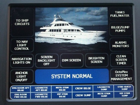
A day aboard the 120’ tri-deck Sandrine will definitely rank high on my Summer ‘08 highlight list. Wow! While I’d actually attended her debut in Miami, and was already familiar with the OctoPlex distributed power system she showcases, it takes a while to comprehend how powerful the system is. The stats help: that touch screen (embedded Windows PC) above is connected via redundant NMEA 2000 networks to 7 other touch screens, 18 electronic DC circuit breaker panels (w/18 breakers each), 13 electro-mechanical AC breaker panels (w/ 13 breakers each), and 8 System Interface Units (SIUs). Each SIU has 34 discrete inputs connected to simple ground or voltage level sensors and switches, such as the yacht’s 175 light switches.
When I was researching a PMY article about VSAT and Fleet Broadband sat comms, I asked a fairly reliable source what would happen if Inmarsat lost one of its new I-4 satellites. He rolled his eyes and said, “they’d be dead.” You see, while it only takes three of the new I-4 satellites to provide nearly global BGAN/FB service, the things are huge, and hugely expensive. Which is why getting the third and final bird into orbit was a big deal. Plus the launch has been delayed at least once due to the failure of a similar missile carrying a smaller satellite. I imagine tension was wicked high when the Proton Breeze lifted off from the Baikonur Cosmodrome in Kazakhstan last night. Can we imagine the financial stress induced watching a critical business asset—for which, by the way, there is no backup—blast into space (especially now that we know how much angst a little electronics bankruptcy can cause). Well, the I-4 F3 satellite launched fine, and thus Fleet Broadband should become global soon. Meanwhile, KVH recently announced that its mini_VSAT service is also going global. I presume that if things go right, a company can do well with satellite communications, but it does seem like a hairy business.
Bummer! The only remaining online sign of the great electronics blog AskJackRabbit is the old About Me page above. Much worse, especially for customers with paid-for orders outstanding, is the apparent bankruptcy of Jack Rabbit Marine. Online grumbling about undelivered orders and unanswered calls actually began in June, and I heard from an unhappy—like $5,000 of unrefunded deposit on canceled order unhappy—Panbo reader in early July. But, like most every one else, I figured the problems were isolated and temporary. Last week, though, the drumbeat of worried commenters at The Hull Truth, NavaGear, and here on Panbo picked up considerably, and finally a couple of customers reported receiving this email from the company’s President, Peter James:
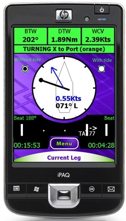
SailClever is a new kid in the sailboat racing tactical software niche, and it looks clever indeed. According to the developers, the Windows Mobile PDA screen at right “shows one of the main screens you would use while racing. It has an arrow to show where the mark is, a pointer to show the direction of current relative to the boat, navigational numbers along the top and then a bar along the bottom that shows what side of the beat you are on and your tacking angle (Downwind it shows gybe angles and reaching it shows cross track error). Pressing the menu button allows you quickly access a number of other screens that give you information on your speed relative to your polars, what the next leg is, what sail you should be using, wind direction and a basic chart.” The SailClever software will do a lot more than that, as well illustrated on its web demo pages. It can purchased alone or with a neat-looking Datasoft RS-232 Bluetooth dongle for connecting to NMEA 0183 ports wirelessly. SailClever also offers an extremely rugged TDS Nomad PDA that’s probably way out of your price range, but do enjoy the stress test video. SailClever claims compatibility with several instrument systems—sometimes two-way, as with TackTick—which distinguishes it from the higher end Ockam Eye PDA software, I think. But note that a few of its features are available in iNavX (don’t miss Gram’s latest), Memory Map, and probably some other PDA/Smart-phone apps you’ll tell me about.