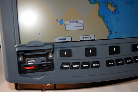
I may abstain from off-the-cuff product comparisons for a while! But whereas I’m already in trouble today, I will express my very mixed feelings about the ColorMax 15, which I actually tested. On the one hand, it’s a notable value—a big bright marine multifunction display with a fast processor and a lot of connectivity going for a street price of about $2,100. This unit may not have a standard Ethernet port, but it does have five NMEA 0183 I/O ports, some of which can be set up (see above) to interface with optional sonar and radar sensors (which may in fact talk Ethernet). It also has two USB ports, seen below, though no stated use for them at this time. That photo is also meant to show that the ColorMax may not dim down far enough for night use in some wheelhouses (without a funky fix I’ll cover one day). But what the unit really lacks is a user interface that takes good advantage of the generous screen space and I/O possibilities. For instance, as noted already in PMY, the only way you can get that four way split shown in the promo photo is to have both radar and sonar attached; you can’t even have two chart windows, let alone the sort of page, window, data box, etc. flexibility seen on most multifunction displays these days. Which brings me to this possibly naive idea: if Si-Tex were to open source a stripped down version of this machine’s code, maybe some amateur developers, and/or small resellers, would make it sing?
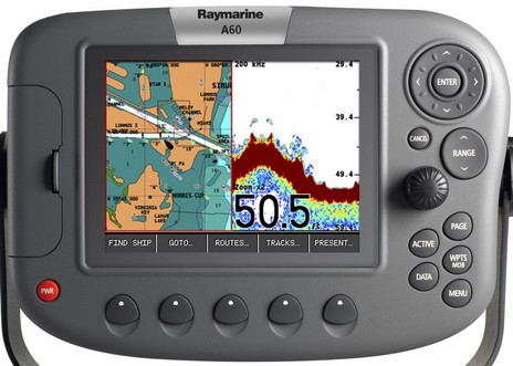
It seems a bit unusual that the folks at Raymarine just announced a new A60 plotter/fishfinder that they didn’t mention at the Miami Boat Show, but I imagine they’re hustling to meet the Garmin juggernaut. After checking out the A60’s specs, and manuals (where I snipped the diagram below), I’d say it’s a worthy competitor to, say, the Garmin 545s. You get a slightly bigger display, 5.7” over 5”, a killer digital fishfinder, and Ray’s C/E-series soft key interface made even simpler as it’s stripped of radar, AIS, wind, and other elements the hardware doesn’t support. The A60 comes with a Navionics Silver card covering all U.S. waters in almost complete detail, plus you can use Gold or HotMaps fresh water cards. The Garmin, of course, has BlueCharts built in, plus you can get g2 Vision cards with hi res photos and 3D, even add XM weather, but is a 5” screen big enough for that sort of use? (Though note that the 545 sports high pixel density, 480 x 640 versus the A60’s 320 x 240.) At any rate, there’s already a discussion going at The Hull Truth comparing the Garmin with Raymarine’s A65, the similar 6.5” model that preceded this new one (at a significantly higher price). But, watch out, I think FlipFlop425’s post is wrong about the 545s having a digital fishfinder. (And, by the way, are any of the new Garmins shipping yet?)
PS 4/18: Yipe, I made mistakes above! It turns out that the internal fishfinder in the Garmin 545s does use digital signal processing, plus you can use its CANet port to connect to an up-to-2kW GSD 22 module. Also, it and the other smaller new Garmins are now shipping (with the 4000 and 5000 series soon to follow). Apologies to FlipFlop425 and also to Garmin’s media guy (whose Blackberry jukeboxed when it started working again early this morning!).
A big thanks to Shine Micro for providing some useful detail about how the FCC is handling Class B AIS. First of all, the MMSI’s will be just like those used in DSC VHF’s (in fact, should be the same one already programmed into your boat’s radio). So, if your vessel requires an FCC station license, then you use the included MMSI. Otherwise you can use a free MMSI for a Class B transponder. And programming the MMSI is going to be left up to the manufacturer, who can do it themselves or pass it on to the dealer or user. However, the FCC is mandating that manufacturers preprogram all Class B devices with a unique unit identifier in the Vendor ID field of Static Data Message 24, and that field must be verified when the MMSI number is programmed during unit activation. Now, I don’t quite understand how that last part will work in practice but the concept of every transponder having, besides an MMSI, a second fixed unique user ID that also identifies the manufacturer sounds to me like smart security, and a useful trouble shooting tool, without undue burden on anyone.
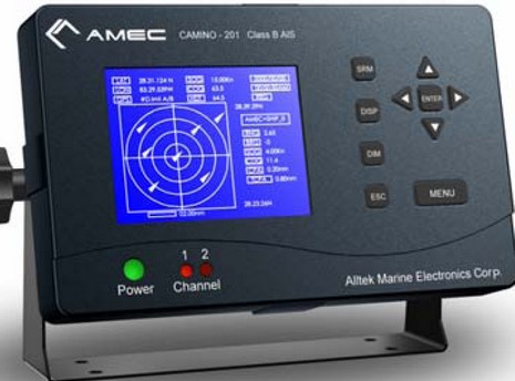
PS: If your company wants to get into the Class B transponder business, Taiwan manufacturer Alltek Marine has units purportedly ready to hit the approval circuit. They come either with or without a display, the former (below) expected to retail for about $1,000.
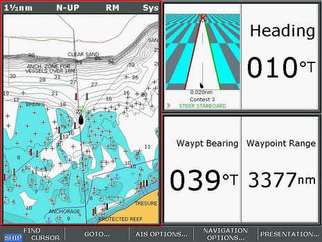
Whereas many of us are hunkering down for a monster low that’s bulling its way up the East Coast (gusts to 70 knots predicted here tomorrow!), another PMY navigation/photo contest may be in order. Above is the Raymarine E screen that’s printed on the inside back page of the March issue, and below is the boat’s waypoint, as shown in a photo from Marinas.com. Where is the lighthouse? And, for extra points, what is the boat’s present location. As before, please submit answers by email, not comments. By the way, I think this one is much harder for Google jockies to figure out, but nonetheless the real contest (with real prizes, but now closed) had quite a few correct answers. How’d they do it?
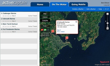
I’m pleased to hear that ActiveCaptain, the “Point of Interest bomb!”, is active indeed. Yesterday developers Karen and Jeffrey Siegel announced that the free site now has over 9,000 marinas and almost 1,000 anchorages, with 35,000 updates and 1,000 reviews from some 2,000 registered users. (And, by the way, hats off to our own frequent commenter “b393capt”, who is the second most prolific “Active Captain”). You can see the informative results of all this activity if you register and scan the U.S. coastline, and pretty soon the Siegels are going to add a “Local Knowledge” marker meant for favorite restaurants, hikes, uncharted shoals, etc. Plus ActiveCaptain is going international. Already, for instance, there’s seed information for 500 marinas in the U.K.—as in Falmouth, Cornwall, above—ready for you Brit Panbo readers to elaborate on. Please do!
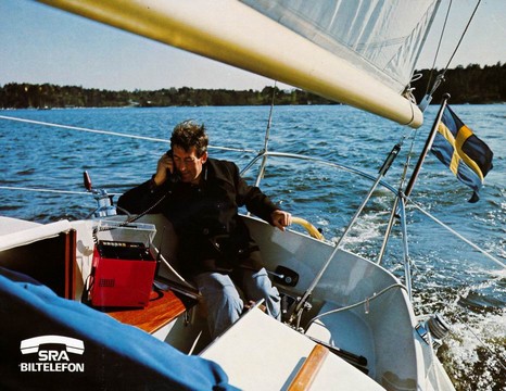
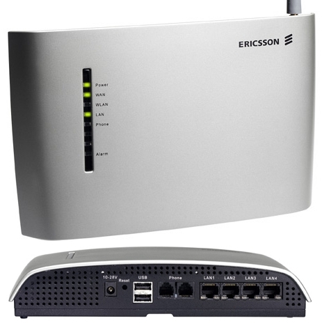
This sailor wouldn’t want to heel too far, or that monster mobile might slide and break his foot! I found this shot at Ericsson’s press site, where the box is identified as an MTD mobile phone from Svenska Radioaktiebolaget (or SRA, an Ericsson subsidiary), circa 1980. The technology has, um, evolved. What I was actually looking for was the new, and amazingly full-featured, Ericsson W25 fixed cellular. It can use either tri-band CDMA or quad-band GSM, including three fast data protocols, to connect most anywhere on earth to using whatever you can attach via two phone jacks, four Ethernet ports, and WiFi. It also features fax support, ac/dc flexibility, twin USB ports for “print server and/or mass storage”, and an external antenna option. I don’t know what it costs, and—according to Alan Spicer, where I found out about it—you can’t quite get one yet, but it certainly appears to fit into the supercellularistic heart-of-a-boat-network category.
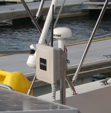
Last night, I had an enlightening email exchange with Aaron Lynch as he tested his new WiFi setup from a slip at Marina Del Rey:
I spent a buttload of money trying to buy high power cards and then pigtails and antennas on the cheap. $20 or $30 here or there, but it just never quite worked. I was going to get the WaveRV USB, but they never responded to me, and their drivers only supported 10.3, not the current Mac OS 10.4. Finally I got so fed up I bought an Engenius 3220 EXT {$170 on eBay, and elsewhere}. I can’t say enough about it! The most important features for me are the 400mw transmit power and an external antenna connector so I can add a yagi or something like that if I need it {it came with the 5dBi rubber stubby shown}. Currently it’s on the stern rail and I’m surfing at 1.7 megabits/sec where before I would surf intermittently, and very, very slowly. Unlike previous Engenius products this one has a web interface that works with Firefox on a Mac. It has a site-survey feature that makes it really easy to see and connect.
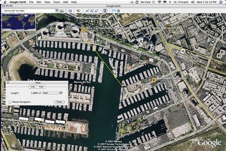
Now Aaron can see 20-30 networks and was able to get online with an open hotel conference room system at about 1,800 feet (illustrated in GE below) and a boatyard that “blew my mind, it’s 1900’ and diagonally through a 60's era concrete hotel building.” The 3220 is a Power over Ethernet (POE) device, like the Port Networks I tried, so you’ll need 110 ac or an inverter. By the way, Aaron has his connected to an Apple Airport Express “which gives me full WiFi signal within the boat, and I can stream music to the stereo too,” but the set up “got awfully complicated” requiring a “weird double-NAT thing.” Thanks, Aaron! (Coincidentally, David Pogue has piece on the travails of WiFi routers in the Times today. Don’t miss the video, especially you Mac fans.)
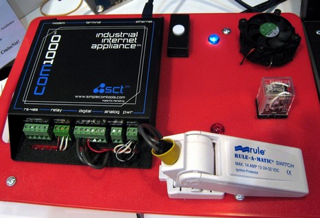
That’s a Shakespeare CruiseNet Cellular Router set up at the Miami Boat Show, where it was cruising the Internet at a zingy 3Mb, and serving it up via the WiFi router at left, which is plugged into one of its four Ethernet ports. When installed on a boat those dual stubbies would be replaced by a pair of marine cell antennas, because CruiseNet’s high performance design incorporates antenna diversity technology. Another reason for its somewhat jaw dropping cost—models start around $1,600, street, without the antennas!—is the industrial-strength, full-power cell transceiver built into the box. Most of the other cellular routers that boaters are fooling with—like the Junxion Box or the Kyocera KR1, or even KVH’s TracNet 100–use a wimpier PC-card-style consumer-grade radio that you supply. CruiseNet also includes a one year subscription to the “Full-Throttle” proxy server compression service Shakespeare has set up (renewable at $50/year), and it somehow establishes a static IP address, which apparently is not easy on a cell network. The IP address means that CruiseNet and everything attached to it can be queried from other computers, which leads to all sorts of possibilities, as was illustrated by the control and monitoring test board Shakespeare had set up in its booth. This product could the heart of a very connected boat, at least until you get 20–50 miles off the U.S. coast, where Sprint and Verizon broadband always-on data service ends. I’m working on an article about connected cruising, and would love to hear how people are using WiFi, cell, sats, SSB, and/or pigeons to stay in touch, or whatever.
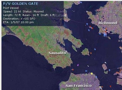
I’m still hoping someone will tell us more about the FCC and Class B AIS, but in the meantime Dan sent a great link to The Nautical Institute’s AIS Forum. It’s not a forum in the usual sense but rather a collection of Reported Problems and Technical Feedback papers. An interesting piece in the latter section is a PDF called Automatic Identification System (AIS): A Human Factors Approach, which strongly confirmed my notion that lots of user entered data is bogus. For instance, of nearly 31,000 AIS transmissions examined in one study 49% “showed obvious errors in the fields of destination and ETA.” Which reminded me of the screen shot Russ sent a while back, showing BoatingSF’s neat AIS tracker on Feb. 8, more than a month after the Pilot Vessel Golden Gate’s ETA! The boat, a violet target headed SW toward its namesake bridge, is also going 22 knots even though its Navigation Status is “moored”. The good news is that user entered data isn’t very important (unless maybe you’re filtering targets based on their nav status), but the paper also confirms a rumor I’d heard that certain Class A transponders can broadcast a default MMSI in certain circumstances, leading to possible duplicates that really mess up the System. Well, it’s true, the MMSI is 1193046, and there’s a link to details about the units, causes, and remedies. We need to remember that AIS is a relatively young technology (and Class B is an infant).
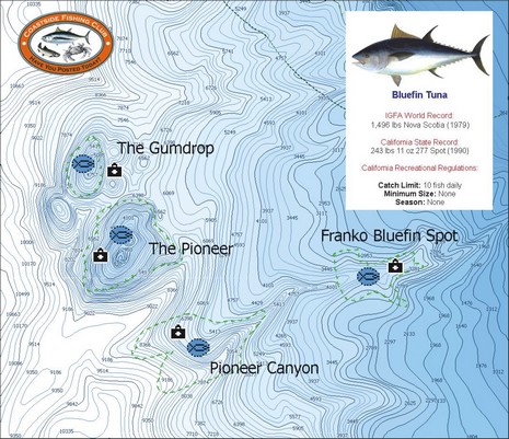
Yesterday another reader emailed, “What's new is the fishing electronics world? It is Spring time, and we just had the salmon opener here in San Francisco!” Well, how about a C-Map MAX Coastside Fishing Club chart card full of hi res bathymetry and other goodies useful for fishing from Pt. Conception, California, to Coos Bay, Oregon? Actually I’m a little confused by the press release’s mention of “exclusive Member’s Only fishing data like IGFA and state record information, local fishing regulations and favorite fishing spots of club members.” C-Map’s catalog seems to indicate that the card is available to anyone, the Coastside Fishing Club makes no mention of it, and, besides, it seems pretty similar to C-Map’s other Max Fish Bathy cards (see 2/06 press release). Maybe someone can straighten this out? And, if you go way off San Francisco, keep an eye out for the unusual radar semi-submersible SBX-1, spotted with an AIS receiver setup that’s purportedly seen targets 1000 miles away.
PS 4/12: It turns out that this card is available to the public, but what most distinguishes it from the Max Fish card covering the same area is the inclusion of hot spots provided by the Club. Thank you Coastside!

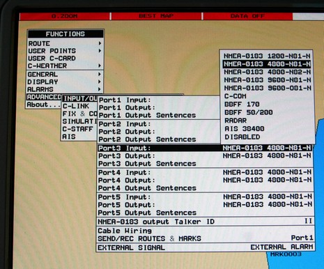
 It also has two USB ports, seen below, though no stated use for them at this time. That photo is also meant to show that the ColorMax may not dim down far enough for night use in some wheelhouses (without a funky fix I’ll cover one day). But what the unit really lacks is a user interface that takes good advantage of the generous screen space and I/O possibilities. For instance, as noted already in PMY, the only way you can get that four way split shown in the promo photo is to have both radar and sonar attached; you can’t even have two chart windows, let alone the sort of page, window, data box, etc. flexibility seen on most multifunction displays these days. Which brings me to this possibly naive idea: if Si-Tex were to open source a stripped down version of this machine’s code, maybe some amateur developers, and/or small resellers, would make it sing?