
Big storm, how about a contest?
... written for Panbo by Ben Ellison and posted on Apr 15, 2007
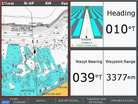
Whereas many of us are hunkering down for a monster low that’s bulling its way up the East Coast (gusts to 70 knots predicted here tomorrow!), another PMY navigation/photo contest may be in order. Above is the Raymarine E screen that’s printed on the inside back page of the March issue, and below is the boat’s waypoint, as shown in a photo from Marinas.com. Where is the lighthouse? And, for extra points, what is the boat’s present location. As before, please submit answers by email, not comments. By the way, I think this one is much harder for Google jockies to figure out, but nonetheless the real contest (with real prizes, but now closed) had quite a few correct answers. How’d they do it?

To all that are trying to solve this puzzle, the best of luck to you.
Respecting Ben's wishes I will not say how I found the Light House, but a heavy dose of Dumb Luck was involved, based upon an incorrect hunch.
Ben was correct that Google Earth is not going to get you there. That is the clevor part of his puzzle I thought.
I could only get within 20 NM of the starting point, I would be curious to know if anyone found the exact starting point and how.
-Mark Read
mark at goreads dot com