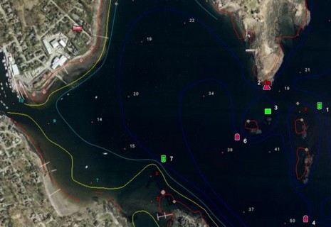
Following up on yesterday’s entry, here’s what the full EarthNC Plus looks like in my home harbor. Note the spot soundings and bathy lines. The 1:20,000 harbor chart has not become an ENC yet, but this represents all the essential data from the 1:40,000 coastal chart overlaid on what’s in many places (like Camden) the highest resolution photography available. But, of course, Google Earth’s photos live online, and as best I can tell, EarthNC Plus does not yet have a way to cache them to a laptop. Plus the suggested method of GPS navigation on these charts is Goops, which didn’t impress me.
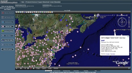
EarthNC has come a long way since December. For one thing there is now an official Web site. And a few weeks ago the company introduced EarthNC Plus, a $50 CD package that can overlay all available ENCs on Google Earth. I’ve been testing it, and will write more about it soon. But today let’s look at EarthNC Online, the just introduced free viewer. You have to install a plug-in from GoogleEarthAirlines which lets you access G.E. from inside your browser. Sounds a little dicey, but it all worked fine for me (using Firefox 2.0).
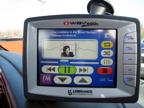
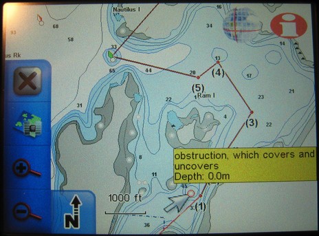
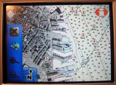
I’ve already written a bit about listening to tunes while navigating the highways on the iWay; how about boat nav? First is the good news that Lowrance has fixed the problem with “obstructions which cover”; you may recall that the “really nasty rock” above, and many like it, were not shown on earlier NauticPath charts. (In fact, the first iWay I got didn’t have them either, but when I piped up, Lowrance said the wrong files were accidently loaded, and sent this one. If you have NauticPaths, you might want to check). Note that the yellow note window popped up when I touched the symbol, and I could get a whole page of info by next touching the “i” icon upper right (ditto with the tides, notes, marinas etc. in the lower image). Note too that tapping the “X” upper left would take me out of this pan and zoom mode and back to my vessel (or car), leaving only a map orientation button lower left. Tap that and you cycle through top down/north up (as shown), top town/course up, and 3D. This applies to any type of navigation; in fact, most everything does. Unlike some Garmins—which switch screen sets and units of measurement along with nav mode—when you go from turn-by-turn car nav to point-to-point marine nav, the only other thing that changes is your choice of cartography. Changing to knots/nautical miles isn’t even a choice elsewhere. In other words, as well as the nautical charts are displayed, boat navigation is secondary to auto nav on the iWay (for more check the manuals here). But let’s not forget the 25 gigs of goodies include nautical charts for the whole country, plus a lot of lakes, plus zillions of POIs, street maps, and photo maps. The latter cover many cities, like Boston’s North End below. (I guess I picked that spot remembering my time there a year ago, getting a little ‘treatment’. Glad that’s over.)
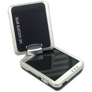
When Captn Jack’s lent me an i-Blue 757 GPS last month, they were clever enough to put it in “logging” mode before they sealed the box. Thus, once I sorted out the included software and downloaded the saved log points (30,591 of them!), I was able to see the box’s UPS trip from Massachusetts to my house overlaid on Google Earth. Now that’s a damn sensitive receiver that can hold onto GPS satellites inside a box inside a series of brown trucks! And obviously the i-Blue’s 1000mAh Lithium battery is pretty long lived even when it’s not being trickle charged by its 25mA solar panel. By the way, note the lat/longs shown in the i-Blue’s PC utility software below; in Google Earth I was able to drill down to a factory parking lot in northern Taiwan where the unit was probably tested for the first time. While I like logging for tasks like mapping island trails, and the i-Blue is certainly an easy way to bring home a visual cruising history, I found that it also serves quite well as a Bluetooth GPS sensor to Pocket PC and laptop charting programs. It even has a unique standby feature that worked fine, and is well explained in this thorough Pocket GPS World review. Note that you use a USB cable to charge the i-Blue and also to download logs and set GPS and logging parameters. I didn’t check if someone without Bluetooth could use the USB connection as a GPS feed, and the otherwise good manual doesn’t say, but I will get another chance as I liked this gizmo so much I’m buying one. I tried an EMTAC Trine Bluetooth GPS that Captn Jack also sells, and while I’d say it’s noticeably sturdier than the i-Blue, I’m going for the lower price and logging capability. I do like how Jack’s is selecting good, better, best products in several categories like this and WiFi, and recommend downloading the new catalog PDF, which seems to include some gear not yet on its Web site.
I hate to be a scold, but an otherwise fine new article about AIS in Cruising World contains this flawed paragraph:
Once an AIS signal is received by the antenna, it's sent to a black box that translates the data into NMEA streams that can be sent at 4,800 or 38,400 baud. The lower baud rate works with electronics suites still using the NMEA 0183 communication protocol; the higher baud rate works with proprietary networks, such as RayMarine's, and devices using the more capable NMEA 2000 communications protocol.
Every AIS transponder and receiver I know of outputs the same way—NMEA 0183 data messages at 38,400 baud. The 38.4k speed rate is called NMEA 0183–HS (high speed) and is included in the current standard. As far as I know there is no AIS using the NMEA 2000 standard or a proprietary communications protocol, though the new Furuno receiver does do Ethernet in addition to 0183–HS and the junky NASA unit apparently filters out some AIS messages before it sends them down the 0183 pike (though NASA claims it uses N2K, God knows why).
I’ve heard a very ugly rumor that the Class B delay at the FCC may be something serious and long term. Can anyone elaborate?
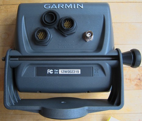
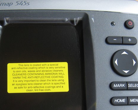
Geez, I’m so behind on testing (Cobra radios and Lowrance iWay are the ones half done, and there’s some I haven’t even started, sorry all!), I hesitate to get started on this Garmin 545s. On the other hand, the interest is great, myself included! Above is a backside shot showing the new two-way swivel bracket, and also the ports. Right is a BNC connector for an optional external antenna, middle is a connector for the still somewhat mysterious GXM 31 antenna, and left goes a cable that contains power leads, 2 sets of NMEA 0183 i/o leads, a set of CANet leads, and a power/data plug for the the dual frequency transducer. The unit is not quite as blue as the picture somehow came out, and the tooling is beautiful. The 545s manual is now online for more info, and I will try to show you what it can do as the week goes on (I’ve got a g2 Vision card too), though I probably won’t get it out on the water for a couple of weeks (and, by gorry, I’m going to finish those other units). Meanwhile I include the picture below as a reminder to everyone installing and reinstalling electronics this spring. Be very careful with your screens unless you’re positive that they’re not coated.
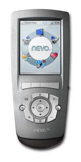
My May PMY column “Universal Aggravation” is now online, and I'm tickled with how Craig Wallace Dale realized our opening illustration idea. How’s that for action electronics photography! You may recall that testing the Harmony 890 won me over to Logitech’s online programming system, but there may be even better solutions out there. I’d heard that Atlantic Marine Electronics programmed a Harmony for every Viking Yacht launched (an impressive move on Viking’s part), but when I called them it turned that they are now using the NevoSL, which is partially touch screen and according to AME “more intuitive.” I also learned from my friend Kim Kavin’s excellent megayacht site, CharterWave, that at the very high end Crestron has a remote that can summon 24 hour cabin service, an idea Kim is not so sure about.
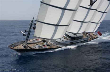
Who isn’t fascinated by the Maltese Falcon, the 289’, $100,000,000 yacht that sails under a very unusual DynaRig, actually three rotating carbon fiber masts carrying fifteen automated square sails on carbon yards? I did get to see a phenomenal 18” model of the Falcon (built by Rob Eddy, another local gem), but I would so like to get a sail aboard this vessel, or least a glimpse at what the electronics its very techy owner Tom Perkins chose for her. I do know that Tacktick is quite proud that its Micronet wireless wind sensors were used to help test the rig during construction in Turkey. And today, which happens to be the Queen’s birthday, the company won the Queen’s Award in the Innovation category. A tip of the crown, then, to Tacktick. I’m pleased to report that I’m going to test a Micronet wind, depth, and speed system on my Rhodes 18 this summer, and that today is finally warm enough to think about boating.
PS: Speaking of Queens, check out this time-lapse video of the Queen Mary II visiting San Francisco. This site, BoatingSF, also has an interesting newsletter on AIS.
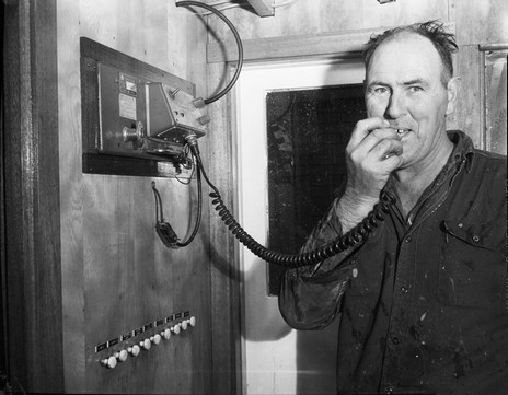
It’s amusing how my little neighborhood on the back side of Camden—once the home of those who manned mills powered by the Megunticook River, and hence called Millville—is now home to some weirdly modern worker bees. While I’m plugging away at Panbo World Headquarters, a good neighbor, Peter Lindquist, is around the corner scanning and cataloging an enormous collection of marine photographs taken by a character named Red Boutilier back in the 60’s and 70’s (when the mills were winding down). The collection belongs to the Penobscot Marine Museum, where it will be part of this summer’s feature exhibit: “Through the Photographer's Lens: Penobscot Bay and Beyond.” This particular shot shows a man aboard the sardine carrier Delca making a call on what I think is an early VHF (?). A typed note in the negative box states that the 78’ Delca was built in 1936 as a minesweeper, then rigged over when the Port Clyde Packing Company bought her after WWII. Then she “worked steady until she sunk on Sept. 7, 1989, 1 mile northeast of Old Cilley Ledge Bell. She was loaded with 1,418 bushels of herring when she went down {due to losing a plank}. Capt. Peter Grew {perhaps above} and mate Dennis Tupper were rescued by the crew of the F/V Diane and James.”
I’ve been using this iWay 600c for a couple of weeks now and there’s a lot to like about it. The turn-by-turn car navigation is first class, and so is the MP3 player. I can’t remember which software I used to rip that Rodney Crowell album, but I just dragged the folder onto the iWay’s hard drive and it took care of the rest, displaying the album cover and track names while sending the sound to my truck’s radio via its FM transmitter. This is not ideal in terms of audio quality, but it’s wirelessly simple and it helps a lot that you can easily adjust the frequency used (those big touch screen arrows at the bottom above) as you drive through sometimes competing broadcast stations. And if you’ve programmed in a destination, or a series of destinations—all pretty easy with excellent Navteq street maps, millions of POI’s on the hard drive, a decent screen keyboard, etc.—the iWay smoothly mutes the music before it delivers voice directions. The navigation/music player combo is pretty slick, and I can easily imagine using it on a boat, at least as a backup plotter. More on that soon.

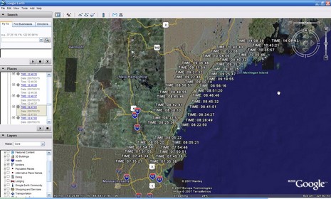
 Now that’s a damn sensitive receiver that can hold onto GPS satellites inside a box inside a series of brown trucks! And obviously the i-Blue’s 1000mAh Lithium battery is pretty long lived even when it’s not being trickle charged by its 25mA solar panel. By the way, note the lat/longs shown in the i-Blue’s PC utility software below; in Google Earth I was able to drill down to a factory parking lot in northern Taiwan where the unit was probably tested for the first time.

 how
how