I’m feeling oh-so-content as 2006 slips away, partly because Panbo has become such an satisfying and promising part of my life. Thank you all so much for reading this blog, making comments, and patronizing its advertisers. I photographed this bit of Americana, bigger here
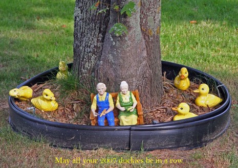
, on Main Street in Stonington, Maine on Memorial Day Weekend, and it made a Holiday card that hopefully suggests the good humor pervasive in this household. Hope you’re all feeling ducky too.
There are only two “Best of” or “Most Innovative of” 2006 marine electronics lists I know of—MotorBoating’s and Sail’s—and neither is public yet, but I like browsing through the more general tech lists that are now hitting the Web waves. So far I’ve come across PC World’s 20 Most Innovative Products of 2006 (they’re list crazy and also have the 25 Worst Tech Products of All Time and lots more). Then there’s Weblog Awards Best Technology Blog 2006 list, and Popsci.com’s innovation of the year is a nail! What have you all found out there?
I just had the disheartening experience of having the Web version of something I once wrote censured because one the electronics companies involved—or someone who thought they had that company’s best interest in mind—didn’t like it. I’m not going to go into the details, but the big magazines I write for were not involved, and what I wrote was A) hardly negative, unless you’re truly thin skinned, and B) truly reported, i.e. information and opinion that really came from the sources, dealer/installers, I referred to. At any rate, I suggested that the editor give copies of the Cluetrain Manifesto to every executive, PR person, or publisher who pressures him like this, because therein they might learn that ultimately they are hurting their own businesses. I first came across Cluetrain in late 1999 when one of the authors, David Weinberger, spoke at a conference here. It turns out that the original site, including the whole book based on it, is still online. Some of the wording may be a bit obnoxious, especially if you’re corporate, but the ideas are not outdated. In fact, I think the Cluetrain concept becomes more self evident, and more powerful, every day:
Through the Internet, people are discovering and inventing new ways to share relevant knowledge with blinding speed. As a direct result, markets are getting smarter—and getting smarter faster than most companies. These markets are conversations. Their members communicate in language that is natural, open, honest, direct, funny and often shocking. Whether explaining or complaining, joking or serious, the human voice is unmistakably genuine. It can't be faked. Most corporations, on the other hand, only know how to talk in the soothing, humorless monotone of the mission statement, marketing brochure, and your-call-is-important-to-us busy signal. Same old tone, same old lies. No wonder networked markets have no respect for companies unable or unwilling to speak as they do. But learning to speak in a human voice is not some trick, nor will corporations convince us they are human with lip service about "listening to customers." They will only sound human when they empower real human beings to speak on their behalf.
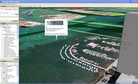
It seems obvious that Google Earth and similar online mapping systems that allow users, individual and otherwise, to create their own overlays will somehow figure in the future of marine navigation, at least for sharing POIs and planning. But, get this, a small Florida company, DestinSharks.com, is already translating NOAA vector charts (ENCs) into Google overlays they’re calling EarthNC charts. I heard about it (thanks, Rich and Rich), signed up for the public beta test, and am impressed. I was getting fancy in the screen shot above (bigger here), using GE’s tilt mode and 3D buildings, but check out how neatly the nav aids, bottom contours, and dredged channel lines lay out, and how (left) you can control overlay elements in familiar GE fashion. But I do hope they figure out how to round the depth soundings back to their original paper chart equivalent (a vector issue I’ve complained about before). And I did see registration issues between some EarthNCs and GE satellite photos (though in this case, Miami’s Sea Isle Marina, the charted pilings seem to line up perfectly). DestinSharks, by the way, is “planning a DVD edition which will offer the full chart set for offline use”, and Google recently added photo maps of my home harbor that are almost as detailed as the most zoomed-in marine panoramas I’ve seen (so far). What else will 2007 bring?
PS 12/28: I came across the fact that Google Earth was downloaded 100 million times during the ten month period following its June, 2005, release as a free program. Yow!
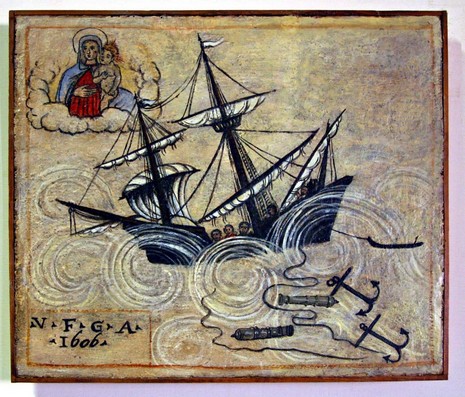
I think of this painting—one of an ancient series hanging in the Venice, Italy, Maritime Museum (and bigger here)—as a how-to for sailors caught out in a storm: Put out all your anchors, jettison heavy objects (like cannons), pray to your personal savior, and hope for the best! Here in Maine we’re trying not to get upset about the freakish fact that the ground hasn’t frozen yet (and I’m thankful that we live some 180’ above sea level). But I trust that whatever happens is all in God’s plan, and I wish you all a very fine Christmas, or Chrismakka as we call it in our home, or however you honor this grand turning of the seasons.
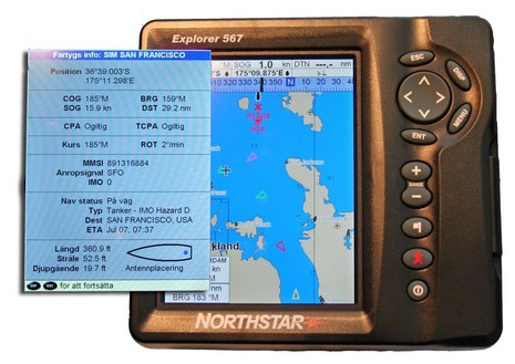
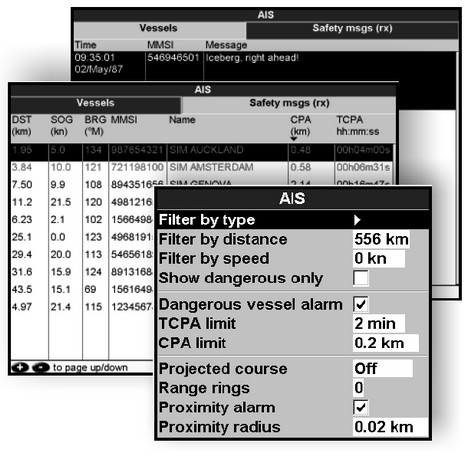
My attempt at a fancy illustration may be sketchy, and the language unfamiliar, but the color coded AIS targets and the full-on data screen behind them suggests that Northstar’s new plotting implementation is exceptionally thorough. The photos above, bigger here, were taken at METS and show one of the ‘new’ Explorer series; its Navman not-quite-identical twin is also getting AIS abilities. Below are screen shots from the new manual for the Navman 8120/Northstar M120 (and the new M84). Notice that AIS text messages can be read, a full target list is available, and alarms can be set on both CPA and proximity. Plus you can choose to have each target project its track based on time (2 minutes to 2 hours), which might help with the Class B jumping bean issue. I have the software upgrade for the 8120 that’s still here in the test lab and a loaner SeaCAS SafePassage 100 headed my way. I’m going to try this…after Christmas. I’m taking a long weekend off, and wishing all of you a wonderful holiday.
When Class B AIS finally gets going, there’ll be yet another issue to deal with: not all existing AIS plotting systems are going to fully understand the Class B messages. Apparently separate messages were anticipated in the original Class A standard but the slotting and details were changed in the final B standard that went official just this spring. I understand that the dynamic data—position, speed, etc.—will likely show, but the static stuff—boat name, etc.—may not until the plotter, ECDIS, radar, or whatever is updated. A good place to see exactly how AIS messages are structured is Brian Lane’s AISparser.com. Among other resources is a neat demo that let’s you turn your own raw AIS strings into targets plotted in Google Earth. Brian is even running a sort of Christmas sale on his AISparser SDK, which I’d guess to be quite good. (Imagine the look on her face!)
And here’s some more good/bad B news: An AIS expert at the U.S. Coast Guard told me that two of the Class B transponders now awaiting USCG approval will “retail for under $900”. But he could not say whose, or when approvals may be issued. Neither could the FCC.
A scupture of B&G, Leica, Furuno, and Team-Italia electronics on a sail-powered teak lawn? Hell, I’d be willing to shave my head too. (More fantastic pictures at Wally and Gilles Martin-Raget.)
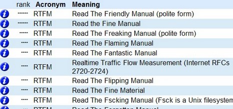
So today I was on the phone with tech support at a certain marine electronics company (it probably could have been many). After a while, the gravelly voice at the other end and I developed a certain rapport. That’s when I happened to ask about a certain confusion in the product manual, and that’s probably why he gave me a truly honest answer. I’m paraphrasing here, but the gist was:
“Man, I haven’t read any of this company’s manuals in over fifteen years. First they develop the specs in xxx (a country) and then the software gets written in yyy (another country), and finally the manual goes together in zzz. In the end it’s not worth a damn! I just push buttons on the unit until I know how it works.”
I got quite a chuckle out of that, and now you know the other side of that old saw, RTFM.
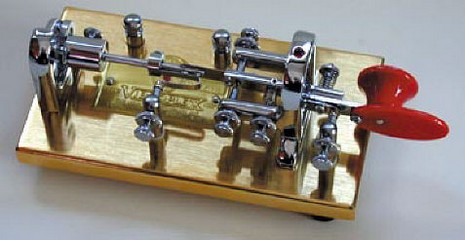
Speaking of SSB, here’s a cool development, I think. Last Friday the FCC announced that it will no longer require a Morse Code test for any of their amateur radio licenses. Thus, as Dan Piltch at Marine Computer writes, “it will be easier than ever for folks to get licensed up, and start using WinLink (with their Pactor modem) for free email”. Dan put up some good dope here. I heard from lots of Panbo readers about this (thanks all!), including TechYacht’s Tim Hasson who pointed out that not all his fellow hams are pleased (as you can read here and here). The actual rule change, by the way, will take a month or more, and that classic Vibroplex Deluxe Bug above is available here should you want to do Morse just for fun.