How about that! The Memory Map Nexrad function for Smart Phones that I tried and raved about now does animation, at right, plus it’s been debundled from the charting software. $10 and it’s yours, no subscription needed, and data use is efficient and user managable. (By the way, developer Richard Stephens may be seriously field testing this product over the weekend, as he again sails the Mackinac aboard Flight Simulator. He says the course is a thunderstorm alley. Good luck, Richard!)
Meanwhile, Panbo reader Bob Mueller wrote in to say that he’s figured out how to get simple Nexrad images onto his not-so-Smart Motorola v710: I host my own website on the residential DSL line in my home, and I created a page with a custom PHP script that I wrote. The PHP script goes to the ADDS (Aviation Digital Data Service) website, pulls a NEXRAD radar image for the area where I boat. The image displays a very large area, that would not be easy to interpret on my cell phone screen. My script then crops the image to the exact resolution of the phone screen. The script saves this cropped image to the hard drive on the web server for display on my cell phone's screen via the phone's web browser. (I would be more than happy to share the code, it is only a few lines!) {Send me a note if you want that code — Ben}.
PS Thanks to Gizmodo for picking up on my Sirius & XM weather testing (even if they somewhat misinterpreted my ramblings); we’re getting major hits, which I find very auspicious as today I officially became sole proprieter of www.Panbo.com. Wishing all a great weekend.
I do feel a little guilty. My buddy Jamie was out there in those islands with friends and family on a Maine Cat 41, and I knew it, but didn’t think to call his cell and advise him about just where those monster thunderstorms were tracking Tuesday evening. Yeah, they’d heard the warnings beeping all over the radio, but still didn’t know if a cell would actually hit them, or when, until one rolled over the horizon (which surely happened, as shown so vividly above). Sorry, Jamie!
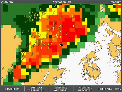
It was too bad because I could really see what was going on, having fired up both the Sirius and XM live weather services I’m testing. My goal was to see how detailed and accurate the satellite information is, and more specifically if it could have helped me get around the worst of the weather in a reasonably fast boat. Conclusion: Yes, if the cells aren’t coming at you in a solid line, and the boat is fast enough. Of course there are numerous subtle differences between the services, and a few anomalies. In the latter department, observe the two photos below, Garmin XM on top (bigger here), Raymarine Sirius below (bigger here), taken at almost exactly the same time.
For some reason Sirius was not tracking any storm cells in New England that evening, i.e. was not generating the arrows that indicate speed and direction, and can be clicked on to reveal more information like chance of hail. XM’s tracking, which nicely indicates the dimensions and speed of the cell, was working fine, but its analysis of precipitation seemed to be markedly off. I was there, and the rain was tapering off just as indicated by Sirius, not about to pour buckets as suggested by XM. Yes, XM shows a 4 minute delay, but I don’t think Sirius was much fresher (it should be time stamped). Hell, that data has to go from the radar station out to a network, through the processing facility, up to the satellites, and back down to these machines. A four minute delay is damn good, especially given this level of detail for the whole U.S.A. And that’s the real story here; I would really like one or the other of these services at my helm. More tomorrow.
7/21 Update: Sirius and data provider WSI are trying to figure out why those storm cells weren’t being tracked (I see a similar problem today off Long Island), and I have a call into XM about why their Nexrad might be a little off. In the meantime, a couple more notes to go with these illustrations:
* I like how Raymarine overlays the weather on a simple outline map, instead of charts, but it would be good to add some landmarks for orientation, like maybe port names. I found myself turning all sorts of stuff off on the Garmin charts, stuff I’d like to see otherwise, so I could see the weather better. On the other hand, the streets and names on the Garmin were useful when overlaying cloud cover, as seen above. Sirius does offer cloud cover, but does have Canadian weather radar.
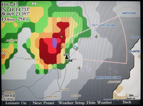
* Garmin’s new “Presets” weather interface is excellent. See the “Storms” lower left on the screen; push the Next Preset soft key and you get the “General” preset, then the “Sea State” preset. The names don’t really matter as you can go into the weather setup area and customize just what mix of data you want for each preset. Moreover—and Garmin has had this for a while—you can specify presentation of individual data types by zoom level. That’s a little harder to get a grip on, but also helps you mix all the data available in sensible ways. I encourage Raymarine to steal the preset concept, and maybe the zoom level too, ASAP!
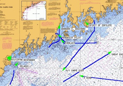
I guess it’s a little pathetic—me spending so much time on the Web, instead of on the water—but I have enjoyed using SeaLinks AIS Live, above, to keep track of some bigger yachts visiting Maine this summer. As of yesterday, Shine Micro, aka SeaLinks, is making users register but it’s easy and free. I don’t know where their receivers are positioned but they surely work well, as seen in the screen shot bigger here. That chart is about 150 miles wide, and Spirit of Zopilote is tucked into Southwest Harbor surrounded by hills. It’s hard to make out even on SeaLink’s small area chart of Portland, but that’s where the 228’ Floridian is now. I first saw her off Camden via AIS last Friday, then in the mega flesh shown below, but AIS couldn’t alert me to the fact that ex President Bush would lunch aboard on Monday. It gets wild around here this time of year! (Here’s the photo bigger, easier to make out the owner’s team—the Miami Dolphins—logo on the copter tail and the Intrepid “tender”, which has triple 285’s on its stern).
PS. It’s amazing how many different ways there are to display AIS on the Web, and new ones seem to crop up every week. Here’s San Francisco Harbor with the ships animated, and here’s shipping along the coast of Germany overlaid on Google Maps or Google Earth (if you register, and have GE installed, but very, very cool). And don’t forget classics like the Irish Sea and the grand daddy of them all, AISLive.com (which also requires registration, but covers many coasts). Enjoy.
PPS. Rosepoint Navigation is testing eight different AIS receivers from Milltech Marine, SeaLinks/Shine Micro, and SeaCas, and we plan to publish the results here on Panbo. Stay tuned (so to speak).
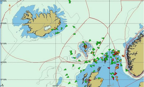
PPPS. The world of AIS, and Panbo, is large. Jan Egholm, part of a team running a commercial AIS service in the Faroe Islands, just sent along this image demonstrating how well a Shine Micro receiver can work on a 750 meter hill. Those AIS targets stretch from Iceland to Norway! Jan’s company Web site is a little tough to read because it’s in Faroese, but here’s a PDF explaining Vikmar’s service in English (there’s much more to Web AIS than megayacht ogling).
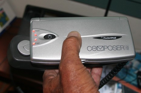
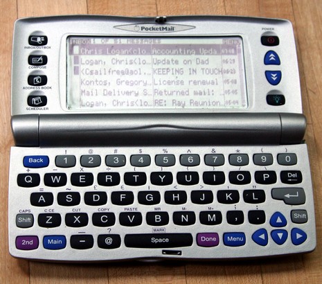
One factor inspiring me to get a bigger boat is an old friend who spend a few days with us recently. Bruce is older than me—which is old—but last year he sold his house and took off in his 34’ sloop down the East Coast and into the Bahamas. He had a wonderful time, and now has the boat back in the Chesapeake for some work, and plans a more leisurely trip South this fall. He kept things quite simple, no computer, but he did invest in that $100 PocketMail Composer above. In the photo he’s dialed an 800 number that came with his $15/month subscription, and then squeezed the gadget’s adjustable earphone and speaker against my handset and pushed the button that activates the acoustic modem. After a period of squeaks and squeals, he had sent and received his e-mail, as shown below. No color screen and no attachments, but the PocketMail system works economically in many parts of the world (In the Bahamas, for instance, there’s a Nassau access number, meaning Bruce could use a cheap in-country calling card at pay phones). Here’s the PocketMail Web site.
Like many blogs, we’ve had a lot of trouble with spam comments. For a while now, we haven’t even let comments go up without first inspecting them, which is a bit of a pain for commenter and inspector (me) alike. I’m pleased to announce that you can now use the TypeKey Authentication Service—which is free and reputable—to post comments immediately. Signing up only requires a name and e-mail address, and your deciphering one of those graphic code thingies that frustrate software spiders. Once acquired, your TypeKey name and password will work on many blogs created with Movable Type. Please register.
We are still allowing comments from unregistered, even anonymous posters, but we have to deal with hundreds of spams a day to make that freedom available. It is tempting to simply limit all comments to folks who are TypeKey registered.
Ralph is in the water and running sweet, but I’m trying to remember that I want to sell it (just can’t call this boat a ‘she’) so that I can seriously look for a larger boat that Andrea and I might cruise for weeks at time, maybe all the way down the East Coast. Ralph is an odd boat, a 1976 Wellcraft that I completely made over in the late 90’s. I’ve just put a pretty complete listing, with lots of photos, at UsedBoats.com. Please be in touch if you’re interested, or just have advice on how to sell it. Thanks.
Yup, a digital radar double header. Garmin announced this stylish 4kW/4’ open array along with a 4kW/6’ model. Note again the DSP claim, “Digital processing allows for more precise recognition, enhancement, and filtering of radar echoes – making the finished display easier to read and interpret.” I only have one screen shot, taken with the $3,600 4–footer, but it does look pretty sharp (below, and bigger here). I also notice in the specs that these arrays can run at either 24 or 48 rpm, which may mean that the display software will eventually be able to show you two ranges at once, a very nice feature on some Simrad and Si-Tex radars. That’s all I’ve got for now; you all have a great weekend.
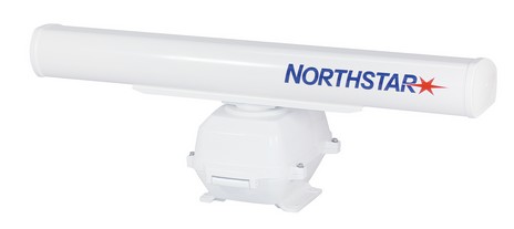
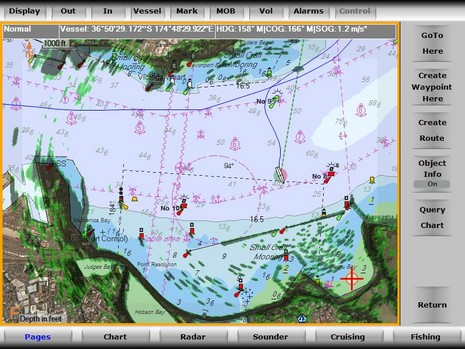
It’s digital radar Friday. It must mean something when two new scanner series are made official on the same day…a trend perhaps? Northstar’s, hinted at last winter, is called High Definition (HD) Digital Radar. and it comes in 2kW/18-inch and 4kW/24-inch radomes, as well as 6kW/48-inch, 10kW/72-inch and 25kW/84 inch open arrays. They will work with the 8000i series, mentioned yesterday, and the new 6100i update to the 6000i series (and come October, the Navman 8120 will become compatible with the smaller scanners). The press release, not online yet, boasts of “enhanced Digital Signal Processing (DSP) techniques, combined with 10-bit target discrimination, provide unparalleled radar images.” I’ve seen quite a few of those images, and they are impressive. Notice how in the one below, bigger here
, the radar is discriminating amongst all those boats moored behind a breakwater in Hobson Bay, New Zealand. Nice!
Brunswick still hasn’t sold its BNT electronics division, but a big reason it might want to raise cash is becoming more apparent. Ever since the stock price popped a bit on the late April announcement, it’s been downhill sledding. And yesterday was awful as BC announced “significant” retail sales declines and plans to reduce production. (Overall this is not a good sign for the economy, or my business, though, wow, BC’s big boats are still selling.)
Meanwhile the rumors about who would buy BNT have pretty much died down…but Northstar/Navman seems to be chugging along just fine. In fact, I’ve got two folders of really interesting screen shots to share in the near future, and BNT ME recently announced a big sale of 8000i gear to Viking Yachts. (Whose sales may be just fine, because…oh, I don’t know…we’re living in the Roaring 00’s?)
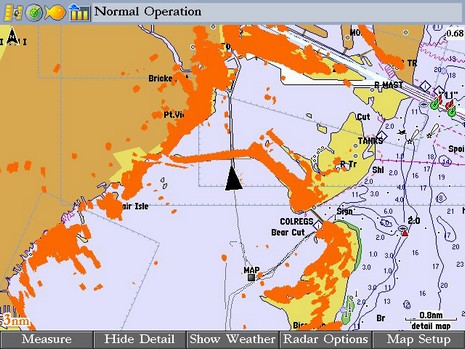
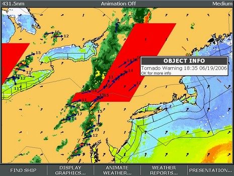
I looked forward to the battle of XM and Sirius marine weather services, and now it’s here. Right now, down in the shop, I’ve got Sirius Marine Weather running on the E-120 and XM Marine Weather running on the Garmin 3210 (and both are ready to go aboard Ralph, which I launched yesterday, yeee-ha). That screen shot above is Sirius on the E, bigger here. You’ll notice Nexrad precip radar, storm cell vectors, water temp, wind arrows, outlines for NOAA text forecasts, and of course the red Tornado Warning area. There’s a lot to these services, and to the interfaces needed to get the most from them. I’m wondering if any of you have experience with either service, or would like to see particular data screens, or just have opinions about subscription weather? Here’s a good page to see what XM beams down, and here’s a similar list for Sirius (click on the FAQ). Don’t be shy!
PS 7/13: An unusual aspect to the Sirius screenshot is that we almost never get Tornados in this part of the world, and it was nice to have a plotter beep me about the possibility. On the other hand, no tornados actually materialized (no fault of Sirius). Below, bigger here, is a Garmin XM image from last evening. That rain definitely did come my way.

 a page with a custom PHP script that I wrote. The PHP script goes to the ADDS (Aviation Digital Data Service) website, pulls a NEXRAD radar image for the area where I boat. The image displays a very large area, that would not be easy to interpret on my cell phone screen. My script then crops the image to the exact resolution of the phone screen. The script saves this cropped image to the hard drive on the web server for display on my cell phone's screen via the phone's web browser. (I would be more than happy to share the code, it is only a few lines!) {Send me a note if you want that code — Ben}.