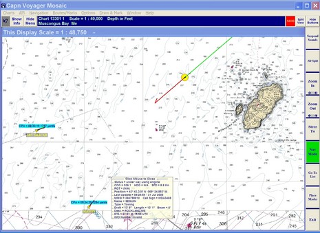
Apologies to Shakespeare. Please do open the full screen of the above, as it nicely illustrates a point I mentioned this morning…how neatly Capn Voyager plots where a Closest Point of Approach is going to happen. I like it and I don’t recall seeing it done before, either with AIS or ARPA (but I certainly could have missed something). The screen shot also illustrates another situation I’d rather simulate than actually experience in limited visibility…an 85’ motor yacht and xx’ tug coming together with me as the possible sandwich meat, worse if I slow down! Now, here’s a question. Class B AIS is just about to hit the market, likely in the $1,200–$1,500 range. But some knowledgeable people think that it doesn’t matter much for smaller boats to be sending out their position, that 90% of AIS’s value is in being able to see what the big guys are doing so you can stay the hell out of of their way. What do you think?
PS. I like software like Nobeltec and Coastal Explorer which can draw AIS targets to scale when you zoom in to an appropriate level, but notice how screwed up the dimensions of the tug Seguin are. I see user input mistakes like this all the time.
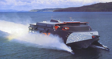
Call me a scaredy cat, but I vividly remember a morning watch motoring in thick fog toward Yarmouth, Nova Scotia, knowing that a sister ship to this ferry would soon overtake us at high speed, fog be damned. I was aboard a 42’ sloop with a dinky 12” radar scanner and a questionable radar reflector (they all are), and I was picturing one of those bows piercing something other than waves! That was maybe six years ago, and I don’t think I’d even heard of AIS yet. If I’d been out there this morning—instead of simulating a voyage using The Capn and live AIS targets (note the CPA graphic)—look at all the information I could have had! Panbo already has a prodigious collection of AIS entries, but there’s lots happening, so brace yourselves for a few more.
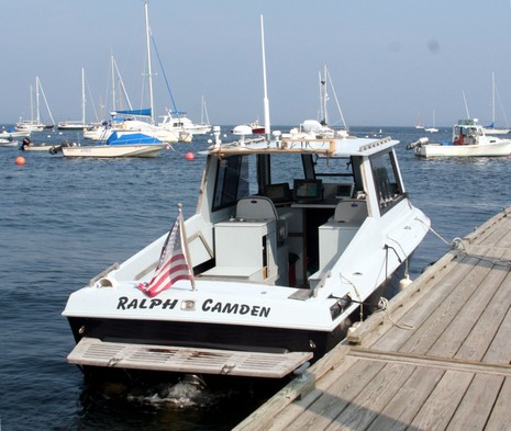
Ralph may be very much for sale, but until that happens I going to keep piling on the temporary electronics. Check out the bigger picture of this rig…dual MFDs, dual satellite weather, and dual ultrasonic weather stations…and some other stuff. By the way, if you don’t get the name, does it help to know that the dinghy is “Norton”? Wishing you a cool and boaty weekend.
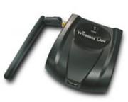
A chap named Wayne B. is very happy with his new boat WiFi set up over at rec.boats.electronics. He says he’s “hitting low power, indoor access points at least 300 yards away,” and expects to get commercial outdoor APs at over a mile. Wayne’s using an external USB-powered NUB-362(EXT) radio connected with 30’ of Hawking CoAX to a 9dB Hawking omni-directional antenna that’s 30’ off the water. Those links go to online sources and the whole kit adds up to around $185, plus, per Wayne, “an adapter to go from an SMA connector to type N coax, also available at CompUSA”. Cool, and less expensive than purpose built marine gear we’ve seen here and here. But I couldn’t get the NUB362’s specs to open and am not sure this will work with my son’s Mac. Anyone know a sure fire way to improve a Mac’s WiFi range?
PS 7/31: There’s another interesting discussion of Wayne’s WiFi rig going on at rec.boats.cruising. Also the whole bundle of hardware is available cheaper at Netgate (though it turns out the radio is only 200mW, not good enough for Jeff). And thanks, everyone, for Mac WiFi booster ideas!
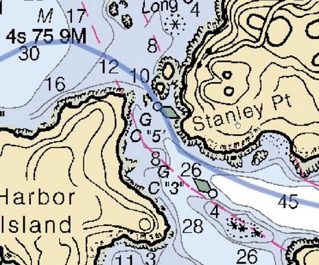
I promise I’ll stop writing about this ledge soon! But it does turn out that Garmin’s optional BlueChart G2 cards, first discussed in May, look good in terms of the great Burnt Coat Harbor bent prop incident. That is the guilty ledge just showing in this photo, taken at approximately mid tide; you can even make out the Can right (east) of it, especially nearer full resolution. Note too the trees on the little islands, a helpful detail that the Cruising Guide chose to emphasize in its sketch chart. Below you can see how the photo icon shows this shot’s view angle. Notice the multitude of photo icons! There’s also a straight down of this same ledge, a view from the north, several pulled back views of the whole channel, something like 12 pictures all together. By contrast, neither Maptech nor C-Map Max has any panoramic photos of this harbor, and Navionics Platinum has 3, but much more pulled back. Could I have missed a photo? You bet; no one seems to have the perfect photo interface yet, and with such a large inventory, Garmin has further to go than most. They’re working on it; the improved icon just arrived in a recent release. Mind you that Garmin’s cards are fairly pricey (especially considering that users already have the G2 charts themselves build in), but I do believe them when they say they’ve spent heavily on helicopter photography.
Looking at the animated version of this graphic too long may make you ill, but it does nicely illustrate the very different schemes that Sirius and XM chose in their efforts to blanket North America in audio and data, including, of course, our recent obsession…live marine weather. Both schemes seem to work fine around the U.S., especially on boats with their naturally wide open sky views, but how far offshore, north, and south can you receive Sirius or XM? A lot of cruisers would like to know, but the company Web sites seem vague on the subject. For one thing, I don’t think they themselves are positive about their footprint edges, and don’t want to over promise. Another issue is that XM and Sirius may broadcast into countries where they are not licensed to, and where someone thinks they should be. You may recall a long period when Canadians could only subscribe to satellite radio using U.S. addresses, even though most could get it fine. XM and Sirius were not bragging about their Canadian coverage then! Both Audio services are now licensed in Canada but, head’s up, Sirius Weather isn’t yet. Which brings us to some legalese in the Raymarine Sirius literature suggesting that your expensive weather receiver might not work if you go outside U.S. territorial waters. Not true; I checked! And judging from the unofficial footprint map kicking around the Internet (right, and slightly bigger here), Sirius will deliver fine service in Canada, out past Bermuda, down to around Antigua, across to maybe the Canal, and actually further into Alaska than shown (so I’ve heard). I understand that XM is similar except that it doesn’t reach as far south, which seems confirmed by the unofficial XM footprint map below, created by WxWorx, the company that’s developed a PC hardware/software system for XM Weather. They’d like to hear more reports from XM users on the edge, and I’d like to hear from anyone who knows more about how far either service reaches. Thanks.
PS, 7/28: We’ve been kindly sent links to a good collection of footprint maps and to a related forum discussion in which one poster describes getting XM in the Azores using a dinky home antenna (though it was before some changes in XM’s satellites).
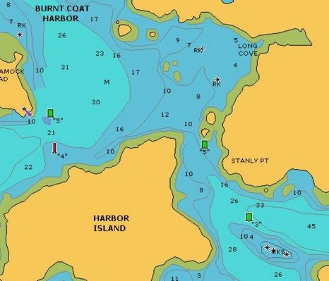
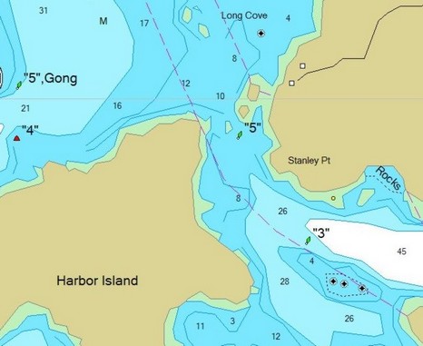
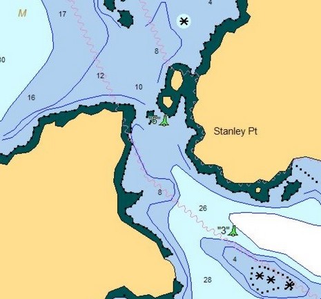
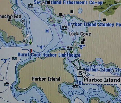
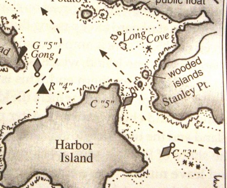
Why haven’t more people who use Navionics charts experienced a C “5” ledge misfortune? Certainly one reason is the Taft/Rindlaub Cruising Guide to the Maine Coast, which contains the sketch chart excerpted above and is consulted in biblical fashion by many cruisers. Notice how useful those dashed arrows are, especially as the overall bouyage—if you happen to be passing right through Burnt Coat, as many do—changes from red right to red left (or vice-versa, because both passages are returning from the sea to a harbor). Heck, my 1979 Duncan and Ware Cruising Guide to the New England Coast talks about how an “able vessel can beat through” this passage “leaving the two cans to starboard”. And that was before chart plotters even existed (and sailors were gnarly navigators, especially Roger Duncan!) Going to the other end of the spectrum, look below how Navionics’ own Platinum grade chart shows the ledge, if you have the top-down photos turned on, including the “land & sea” option (full screen here). There are many ways to get by that Can without damage. But before anyone starts judging yesterday’s ledge leaper a fool, they should take another look at the plain Navionics chart image, excerpted at right. It’s a clean-looking, easily-read chart, just what we’ve been asking for. But not only did Navionics leave out the ledge, the very vector gods (who actually ‘draw’ these charts) conspired to worsen the error. Look how the extra big Can symbol (which I like) hides the fact that there’s any water at all between it and the little island (though, mysteriously, not below). My point? Vector charts are “smart”, they really are, but sometimes not as smart as a cartographer placing a Can just so on a paper chart, or someone who’s been there simply sketching some guidance.
Panbo readers who’ve been with me for a while may remember how I’d regularly link to my Power & Motoryacht columns as they simultaneously came out in print and online. It worked nicely, I thought, as the columns often brought together the blog noodlings into a more coherent whole. But that came to a screeching halt last fall when, due to personnel changes, PMY cut back on what went onto www.powerandmotoryacht.com. Well, the situation seems to be changing. My 2006 columns aren’t up yet, but PMY did recently post the features from our June Electronics issue, including my opus on PC charting programs (and also Pete Dubler’s hands on experience with M-Tec marine cellular gear and highliner Karl Anderson’s take on creating 3D bathymetry). I dare say the same gentleman is also responsible for putting much of the Voyaging Spring issue online, including my Helm Shot column, profiling Steve Smith and his Raymarine H6, and Hudson River Melting Pot, a totally non electronic feature that I had a lot of fun researching. Plus Sail has put up a page linking to PDFs of its three May communications articles including my take on significant 2006 products. When it rains, it pours. My understanding is that both PMY and Sail are working on vastly more informative Web sites, and it’s my hope that Panbo might be involved in that effort. (In the meantime, thanks to all who dropped something in my PayPal tin cup yesterday.)
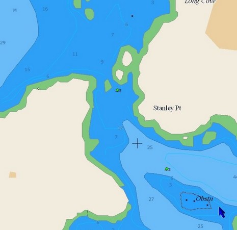
This is what the gentleman saw on his Raymarine plotter, bigger here, which is why he says he cut between Harbor Island and Can “5”, and that’s why he’s now hauled out having his bent props, and maybe more, repaired. Ouch! Navionics missed a ledge, a pretty important one. In fact, the thing is vaugely drawn on the official NOAA raster chart, heavily zoomed below (and also showing my fortunately uneventful track through the same beautiful area last summer), but still every other brand of vector chart I looked at did manage to get it right. (The images futher below—C-Map, Garmin, and then Nobeltec—all show the ledge and are interesting to see side-by-side, but note that how they display varies a lot from one device to another and also according to how variables are set). Now, I believe that electronic charts are pretty reliable (the Lowrance NauticPath and ENC display issues aside, probably all fixed by now anyway). But I also suspect that every vendor—even NOAA (by the way, the 1:40,000 ENC for this area hasn’t been issued yet)—makes mistakes. Just like the splash screens and navigation manuals say, reliance on a single data source is not a good idea (especially when the bouyage appears confusing, which in this case will get another entry). In the meantime, I’ve learned from Navionics that this error has been reported and will be corrected in the next regular annual update if not before.
It was a miserably rainy weekend here in Maine and much of the East Coast…lousy for boating, but good for testing weather systems and fooling around with blogs. It took Yme and I longer than anticipated to actually transfer all of Panbo’s accounts, but now it’s done, and I’m feeling a little frisky. Hence the slightly modified blog name, header graphic, and sidebars. Yes, that is the threatened contribute link over there. I do spend more time on Panbo than is economically justifiable, so here is a way appreciative readers can help…until the big sponsorship revenues kick in (smile).
At any rate, please join me in a big thank you to Yme Bosma who founded Panbo—including coming up with the mysterious, but memorable, name—and is now toiling away at the amazing Eccky and no doubt many other high tech endeavors. Here’s wishing him some dry air and fine boating.


 A chap named Wayne B. is
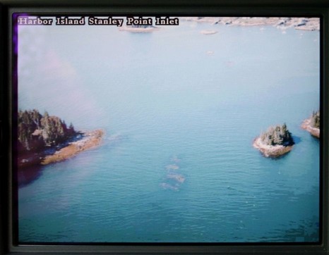
 Looking at the
  go outside U.S. territorial waters. Not true; I checked!
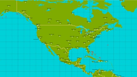
 mage.
mage.