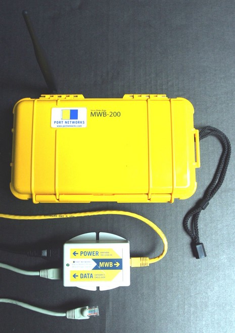
My photo is none too great, but at least at bigger size you can make out the hardware components. Port Network’s approach to marine WiFi is not a fixed high dB antenna but rather minimizing the distance between an independent, well amplified WiFi radio and its relatively small antenna. The wiring is further simplified by ‘injecting’ power into the 25’ Ethernet cable. The result: a waterproof, portable WiFi bridge that you deploy on deck when you anchor or tie up. I’ve tried it now in Boston and around Camden Harbor and can say with assurance that it locks in way more WiFi signals than my little Linksys PCMCIA card. It finds available access points automatically, too, though you can use a browser to get into its extensive software, below, and survey what APs are in sight.
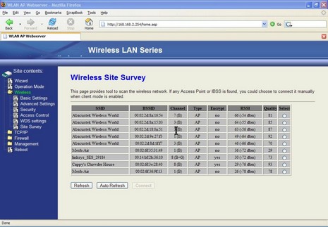
The screen shot, incidently, shows how two commercial providers, Abacus Technology and Mesh-Air, have blanketed Camden Harbor with WiFi, and right now the latter is giving it away. Thank you, Mesh-Air. I could barely get two of those APs with my regular card, but I must say I’m curious how this thing would work with a 9dB antenna. On the other hand, it would quite handy as is in several hotels and other situations I’ve been in over the last year. (Here’s a PDF describing the MWB-200 in more detail, and here’s its online store blurb).
PS, 6/15, Port Networks comments:
To answer your speculation about how it would perform with a 9dB antenna: great, when it worked at all. Here's why...
Omni antennas like these are passive devices, achieving their gain by focusing the signal passing through them. They redirect signal that would go up and down, using it to push farther out to each side. (Imagine someone taking a ball of dough and squeezing it down into a pancake. The radius of the pancake is considerably larger than the radius of the ball, and that's the gain.) The tradeoff for higher gain is less coverage -- relatively little signal is being sent above and below that horizontal beam. With a very high-gain antenna, the beam is so flat that alignment becomes critical. If the antennas on either end aren't in exactly the same plane, then they won't even communicate. We chose a 5.5dB antenna to provide a balance between gain and a wider beam. A 9dB antenna would provide twice as much gain, but if the boat rolled, or the antenna wasn't at 90 degrees to the path between the two radios, etc., the signal might be lost entirely.
P.S. I should mention that the above applies primarily to omni antennas. Another way to get gain without giving up too much beamwidth is to use a directional antenna, akin to the reflector inside a flashlight. We will be introducing a second model with a directional antenna shortly. By virtue of its directionality, it will have to be aimed, and you'll therefore need to know the location of the access point to which you want to connect, but for those people who are in the situation of trying to connect a long way within their own marina, it will offer twice the gain of our current model.
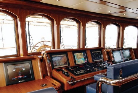
This is the first wheelhouse photo I’ve seen of Jim Clark’s Athena, and it sure looks like the thoroughly PC followup on Hyperion we expected.I wish I had more detail on the electronics, but neither Seascape nor Royal Huisman is giving much away. In some respects, the most interesting aspect of the photo above is that I saw it at beautiful resolution (shown here) in the latest (June/July) online edition of Professional Boatbuilder. PB, or ProBoat, or whatever, is one of the best marine publications out there, I think, but it used to be damn hard to qualify for a subscription. Now the whole magazine is available online to everyone, and in a format that I find very readable on my various PCs. ProBoat has actually been doing this for a year, which means that Nigel Calder’s interesting three part article on “Networking: The three-cable boat” is completely available, starting with the Oct/Nov 05 edition (and also means, by the way, that I was wrong when I first mentioned the series here).
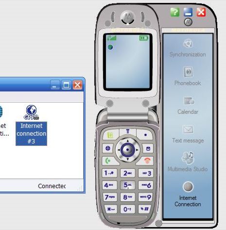
I’m happy to report that GSM phones not only do voice calls in midcoast Maine (finally), but also data. The bit of screenshot above shows a program called Motorola Phone Tools Deluxe 4.0, which can set up an Internet connection quite easily (though I did have to call Unicel for an ‘apn’ address because it’s not one of the many presets). Once set up, it’s just a matter of plugging the phone into a standard mini USB cable and hitting that lower button. It shows a speed of 230 Kbps (though it doesn’t feel that fast) and it logs the amount of data passed. This bodes well for checking my email when I’m beyond local WiFi access points. The software, by the way, also does well at backing up the phone, synching it with selected Outlook calendar and contact info, and making your own wall paper and ringtones (the long intro to UB 40’s “Rat in me kitchen”, if you must know…and, sure, you can have a copy
). Plus the phone charges via the USB cable.
Meanwhile, I’ve continued to experiment with GYMsim. It works fine in Boston, on my phone and also on my daughter’s unlocked Sidekick, but does not seem to work with my local Unicel GSM service. The voice mail is nicely done, and you only pay the base rate (.39 Euros a minute) to listen to them (unlike some cards where you’ll pay roaming fees both for the getting and listening to the message). Best test: I handed the package to a friend flying to Copenhagen on Friday, then called the Liechtenstein number today. GYMsim is working fine for him, and he’s already figured out how to query his remaining balance and “top up” at GYMsim’s site.
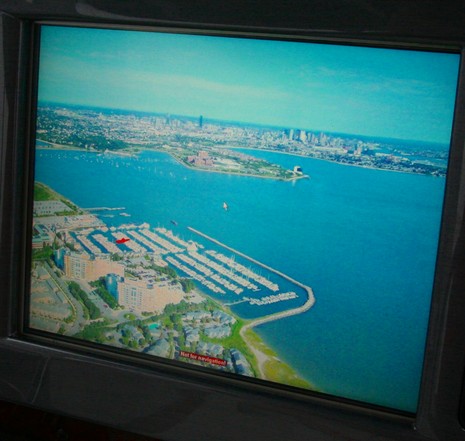
I’m pretty sure that Maptech was the first to add panoramic photos to its electronic charts, but now they’re everywhere. Nobletec Passport Deluxe, Navionics Platinum, C-Map MAX, and Garmin BlueChart G2 all have their own (or licensed) panoramas. But Maptech has upped the ante, at least on the SRN/i3, figuring out how to georeference the whole photos, not just where they were taken, so your boat can be overlaid on them. It is not critical for navigation, but it is cool. Check out the larger size image of the above panoramic showing Quincy’s Marina Bay with Boston in the background. I’m not sure the overlay always works out as neatly as this, but there in red is the Sea Ray I took this picture on, perfectly positioned in her comfortable home slip. Speaking of which, I am now comfortably back in Maine, my apartment and treatments in Boston all history. Hallelujah! I don’t care if it rains all weekend, and I hope you’re feeling the same.
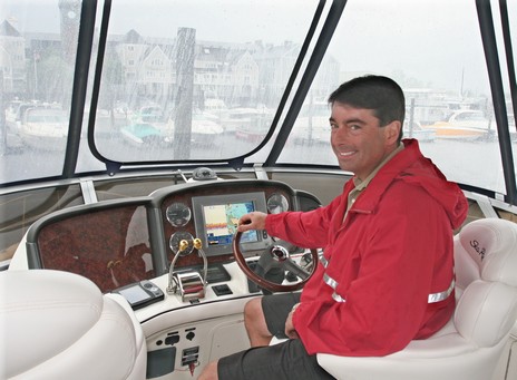
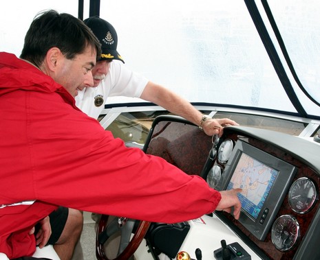
So here’s where I was during some of Wednesday’s Northeaster, on the bridge—tightly enclosed, thank goodness—of Dennis Barca’s spanking new 2006 Sea Ray 44 Sedan Bridge. The occasion was a chance to observe the training portion of the “Red Carpet Advantage” which Maptech includes with that Sea Ray Navigator on the dash, also known as a SRN, and also marketed as the i3. The Red Carpet concept means that if a new owner like Barca registers SRN (who wouldn’t?), he gets an extra year of warranty, for a total of three, and a two hour SRN orientation onboard his own vessel. The training is wisely scheduled for a few weeks after he or she has taken possession of the boat and has thus had a chance to try the SRN and develop questions. In fact, Barca had already owned a smaller Sea Ray with the first generation SRN on board. He definitely noticed the many improvements in this third edition (well described at Maptech), as did I. The tutorial was delivered by Rick Kilborn, below, founder of a neat training organization called Boatwise, which offers all sorts of courses including docking using your own vessel, and has been contracted and trained by Maptech to deliver the Red Carpet in New England. At any rate, it was too soggy/windy to get underway but I think Barca learned more than he already knew about his SRN, and he’s definitely a satisfied customer (as can been seen better in bigger versions of the pictures above and below).
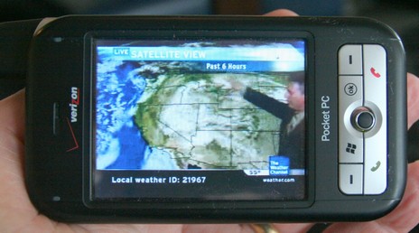
The impressiveness of the above, bigger here, was no doubt heightened by how BIG the weather was around Boston today. I was supposed to go boating on a 44’ Sea Ray but even a few hours tied up in a very protected marina felt heroic given the volume of wind and rain. The project was interesting and I’ll tell you about it tomorrow, but today I’ll just show you the wild and crazy phone one of the guys pulled out. That is the Weather Channel playing on that Verizon XV6700 and it looked and sounded quite good. I was tickled a few weeks ago just to see just static Nexrad on a phone; this TV feed included not just animated radar and sat imagery but a live forecaster (as long as high speed EvDO is available). And it’s source was not some Web site but rather the owner’s own home TV setup which is equipped with a Slingbox, able to serve whatever channels he already pays for out to the Web where he can watch them even when he’s not home, even when he’s rolling around on a boat. The software is SlingPlayer Mobile and apparently it can even control a Tivo type recorder. So beyond live Weather Channel are a lot of other intriguing possibilities.
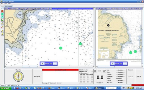
I’ll characterize NavGator Mariner, above, as a work in process. I couldn’t find many normal ECS features, only rasters are supported, and the chart management is crude to say the least. What’s interesting, though, is that NavGator is written in Java so that it can run on multiple operating systems. So far that means Windows, Linux, and Sun Solaris, but others will “soon be released”. The developer also has a Pro version “designed to be the core of the ‘glass cockpit’, where all electronic functions are integrated into a seamless, highly reliable, high performance environment.” The full screen shot is here (also showing off the full 1440 x 900 pixel goodness of my new laptop LCD).
So immediately after I bragged/blogged about riding the high tech LimoLiner to New York City, I managed to incapacitate my laptop! It was pouring buckets when we stepped off the bus, but I just didn’t think about leakage through the zipper of my snazzy rolling computer bag. I’d left the laptop in standby mode, too, which I think may have compounded the poor thing’s fragility to a few drops of water. At any rate, I did notice moisture and I did try to dry it out, but when I turn the old Gateway Solo on all I get now is a “can not find operating system” error message. It may be repairable (and I do have a boot CD back in Maine), but I thought this a good excuse to buy a new mobile computer (with a wonderful 17” screen). And I lost very little data as I’m fiendish about backing up (pat on back). Still, the whole deal has set me back time wise, and I don’t yet have all the software tools I need to create full Panbo posts. So posting may be raggety here until I get back to Maine at the end of this week. Treat your electronics better than I do!
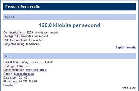
If you ever travel the Boston to New York corridor, you might want to try LimoLiner, a high-end, 28–seat bus that runs several times a day from a Hilton next to the Prudential Center to another Hilton at 53rd and 6th Ave. I’m aboard right now, and this thing is wired! I’m listening to CNN through a pair of noise cancelling earphones and there’s a fairly new DVD movie playing on the other flat screen in my area. I’m also using an onboard WiFi network which in turn is using a Verizon cellular data connection, a setup that looks attractive for boats too, as we’ve discussed before. I don’t know if the particular Verizon radio on this LimoLiner supports high speed EvDO (well covered in a recent PC World), but I doubt it as I haven’t seen really high speed performance even as we passed through downtown Hartford. On the other hand, I’ve had a fairly decent connection—as seen above, and using 1x technology I think—most of the trip (CNN has stuttered some too), pretty impressive at around 60 MPH. Maybe this bodes well for a boat cruising along the coast hereabouts. By the way, I learned that Verizon is the data provider from the voyage attendant, who also served lunch and a snack. Not a real liner but a really nice bus. Have a great weekend.
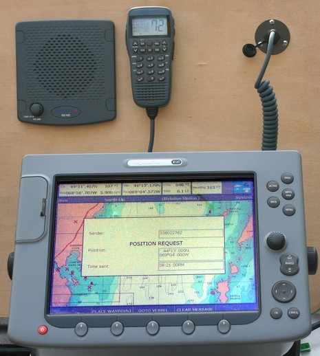
Above, in a scene from my DSC testing, the Northstar NS100 has just received a position requested from another radio and the E120 has automatically picked up the message and is offering to place a waypoint and even make it a “go to”. Very cool, except that when you look at the bigger picture, you’ll notice that the position received is an overly tidy 44 13’.000N by 069 04’.000W. It’s damn hard to get yourself that geopositionally neat, and in fact I’m pretty sure this had to do with an ugly little DSC detail known as the M821 expansion. Apparently the original DSC spec had radios sending position in whole minutes, probably to save bandwidth. Later ITU recommendation M821 lets manufacturers optionally broadcast to the accuracy of the attached GPS. That means that the radios have to ask for and send the extra digits of lat and long as another message. DOH!
Actually all the radios I tried (Icom 504, Uniden 625, and Standard Horizon GX3000S, besides the Northstar) seemed to handle the extra precision fine. I suspect that the zeros above, which I didn’t notice until I looked at the pictures, were the result of the second message somehow getting lost. Still, I’m told that there are plenty of “minutes only” radios out there, so if you ever see such a neat DSC position, realize that you’re looking at the corner, bottom right in North America, of a location box that’s one minute square (which good map heads will know is always a nautical mile high but only a mile wide if you’re on the equator).
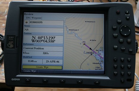
Finally, note that what you see above is all that a Raymarine E or C series will do with a DSC position, whereas the Garmin 3120 below (bigger here) and some other plotters will let you attach names to MMSI numbers and will keep lists of received calls. I asked Raymarine about this and a product manager said that while he thinks the naming/listing features are cool, he’s not sure they worth the programming resources because so few boaters are really using DSC yet. Point taken!