This whole last week was rich with AIS-related matters, including a fine visit with Fred Pot, but yesterday it got almost silly. First I got a call from Jeff Moser at PMY (who’s turning out to be a talented and good humored addition to the staff there), asking if I could write a feature on AIS for a special annual pub called the Yacht Owner’s Guide that’s oriented to bigger boats. Of course I will, why not, says I (FYI: I’m committed to my monthly PMY columns, and wonderfully free to choose their subject matter; everything else is by suggestion, from one direction or the other).
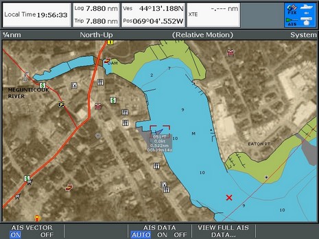
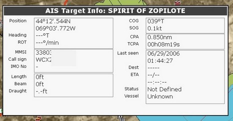
Latter in the day, I hooked up Fred’s SafePassage all-in-one AIS receiver/dGPS to the Raymarine E-120. Everything worked well, and darned if I didn’t see my first AIS target right in Camden Harbor (the screen above, bigger here, shows what happens when you first cursor on a target). And darn if it wasn’t Spirit of Zopilote, a well known 64’ trawler operated by a gentleman named Bruce Kessler, a reputed guru of offshore power boat cruising. I called the marina owner, who checked with Kessler, and minutes later I was onboard taking pictures and having a great gam with Bruce. So AIS helped me collect some excellent material for an AIS article, and Panbo entries to come! (By the way, Kessler is aware that he hasn’t yet re-entered some of the static info, like length and draft, since his Furuno FA 100 came back from an update, and, yes, I did obscure part of his MMSI and call sign).
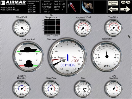
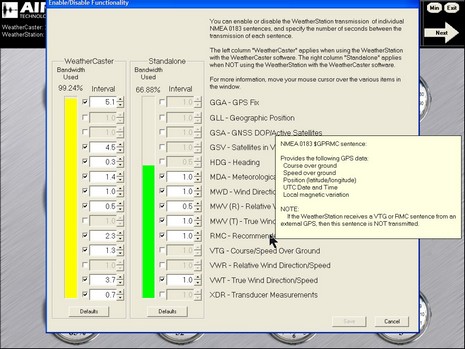
This software (bigger screen here) is still in beta but it seems quite stable and adds a lot to the Airmar Weather Station, including a new name for itself, Weather Caster. Note the new pitch and roll dial; heck, I didn’t even realize that there was also an inclinometer in that casing, along with wind, GPS, heading, temp, pressure, and humidity sensors. The other big update is in the “Advanced Setup”, where you can now flash the weather station firmware (worked fine), and also control the sensor to some degree. Below is the NMEA 0183 output screen, bigger here, which is impressive, giving an ‘advanced’ user or installer complete control over the limited bandwidth, even pop-up definitions of 0183 sentence types. It’s interesting that while this and the Maretron weather station are largely meant to sit in the background feeding data to your main displays, you need a PC connection to keep them up to date and either dedicated PC software like this or a dedicated display (Maretron) to see every bit of the information they generate. At least until the display guys catch up with the available data.
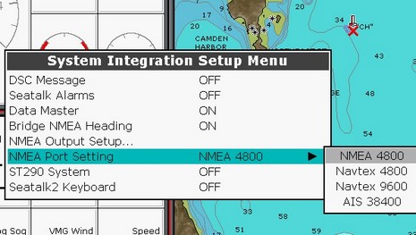
I think the input/output architecture of Raymarine’s C- and particularly E-Series is really quite good. In fact, I’m amazed that the E is still the only system out there offering both NMEA 2000 and Ethernet networking, though the two work together beautifully. But a problem is cropping up. C’s and E’s have only one NMEA 0183 port, but Raymarine keeps adding things you can do with it, mostly recently AIS and Navtex. As the E manual says, “You can connect either AIS or Navtex or other instruments to one display” (emphasis added).
Now, if you have more than one display in your E-Series setup, each can handle a different 0183 input, and the data will be shared across both the Ethernet and NMEA 2000 networks (nice!). But if you only have one E, or a C, well then you may need to investigate the sometimes complex world of multiplexors (referenced at the bottom of this AIS entry). But don’t expect them to multiplex Navtex because apparently that’s not really 0183 protocol anyway. Raymarine tells me that they really wanted to put more 0183/whatever ports in these machines but just couldn’t fit them along with all the other I/O. The limitation might come in to play when, say, choosing between a 2000 or 0183 ultrasonic weather station.
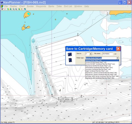
Navionics kindly sent me soon-to-be-shipped version 3.13 of NavPlanner, but I’m afraid it’s not going to satisfy the critics (some of whom ganged up on this software rather fiercely at The Hull Truth). The screen shot above shows all the plotter file formats it supports, as well as some interesting bathy detail off Key West on a Fish’n’Chip. 3.13 does seem faster, and it handled every kind of chart card without crashing, and I was able to build, save, and open various route types without trouble. However it’s still pretty clunky software. For instance, there is no simple hand grab tool to position the chart just where you want it, and when you try to move off the visible chart while mousing a route it doesn’t even know to pan without getting additional commands. Also you can’t change the type of depth unit used (usually an advantage of vector charts) and most U.S. charts are thus shown in Meters.
I could go on, but suffice it to say RayTech 6.0 handles Navionics charts much better, especially Platinum ones. In fact, even, say, Northstar users might want to do their planning in RayTech and then just use NavPlanner to convert the routes to their format. That’s possible (I checked), but there may be other ways to make the transfer, especially as RayTech will export routes to coma delimited or Excel formats. And note that Fugawi is just about to add Navionics card support to its ENC software. (Both Raymarine and Fugawi will sell the special reader needed for about $75).
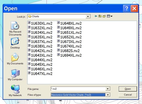
But if you are using NavPlanner, I can help you out with one annoying detail (that I’m told will be fixed in a future version). Right now NavPlanner (unlike most every other chart viewer out there) does not automatically, or even semi-automatically, register charts and then graphically show you what’s available. Instead you have to find the "Charts" folder and then pick your desired region from a coded list, like below. This is an extreme example as that’s a Silver card with the whole U.S. Coast on it, but even a regular XL3 card has 3 XL files on it. Which is where? Navionics doesn’t have an online code list but I found one at Boaters Land.
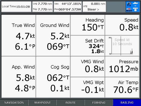
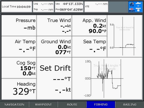
This example will be less funky once I get this whole test rig on the water, but still that’s an impressive screen shot. All that data is coming from, or calculated using, the NMEA 2000 output of Maretron’s weather station, compass, GPS, and water speed/depth sensor. The simulated ‘boat’ is underway but almost standing still (SOG = 0.1 kt) though there’s 0.8 kt of water going by the hull (me flicking the paddle wheel). True Wind then—sometimes called True Relative to Boat—is Apparent adjusted for Speed Through Water and Heading, and Ground Wind (sometimes called True!) is Apparent adjusted for COG/SOG. (A more thorough discussion of True Wind might be in order).
And—yes, contrary to yesterday’s post—there’s Barometric Pressure and Air Temp from the WSO100. It turned out that the E Series doesn’t recognize the standard NMEA 2000 “Environmental” PGN, but will display an alternate PGN that can be turned on in the WSO. This sounds like the screwy stuff that happens with NMEA 0183, and sure enough the E also has an issue with the 0183 “Environmental” sentence, which apparently is marked “do not use” in the NMEA handbook. But Airmar says it’s the only message available for pressure, temp, and relative humidity.
At any rate, the data on the screen below is all coming from Airmar’s all-in-one ultrasonic weather station (and will be joined by pressure, etc. when Raymarine does another code release). True Wind and Set/Drift aren’t calculated because there is no source of Boat Speed, though that would be easy by wiring a speed/depth Smart Sensor into the Weather Station’s Combiner box (multiplexer). Some other day I’ll discuss comparative accuracy, value, etc., but for now I think it’s impressive that the E Series (and C) can interface with both these super sensor systems. The screen shots also illustrate the vastly improved data window control that’s come to the C and E. You can customize the five preset panels pretty extensively (blame me for the asymmetrical graph cells), and use the panels full, half, or quarter screen on any given page. Well done Raymarine, Maretron, and Airmar!
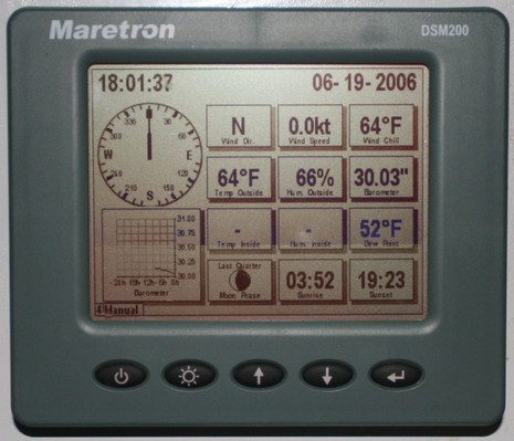
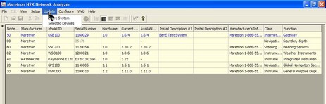
As you may have noticed from the antenna farm, I’m trying the Maretron Weather Station announced last fall. It’s hard to imagine an easier physical install…unscrew a T in the NMEA 2000 backbone, add new T and the WSO100 sensor, power and data done. The Raymarine E, plus RayTech 6.0 on the SeaTalk HS bus, immediately got the ultrasonic wind speed and direction data. Coastal Explorer got it too, as no doubt other PC programs would, via the Maretron USB Gateway (in other words converted into NMEA 0183 messages). Air temperature, barometric pressure, and relative humidity are a different story. There are NMEA 2000 and 0183 sentences for this data but so far nothing I have reads them all except Maretron’s own display. Obviously that’s also true for derived values like wind chill and dew point. At any rate, the display did need updating to understand the WSO100 and put up new screens like the one above, and Maretron has developed a nice program called NK2 Network Analyzer (below, and bigger here) that can update any device on the backbone. (PS: Just noticed that Maretron has put up a demonstration program).
It’s late and hot out, and I’m behind in so many ways…so how about a little this ‘n’ that:
* Remember the guy who was out trial sailing his schooner Maggie B. off Nova Scotia in March? Well right now he’s 13 days into a passage to Brazil and just about to cross the Equator. If I understand his Web site correctly, his crew are four French mademoiselles and an English engineer. Damn!
* NavimaQ is back. I remember back in ‘99 interviewing the couple that first developed this early and popular Mac charting program, literally as they sailed their cruising boat down Chesapeake Bay. Neither the cruise or marriage worked out, and NavimaQ has been off the market for several years. Now Barco Software has rewritten it for OS X, but it looks to me like they’ll need to market it better (more screen shots, demo, etc.) to have a chance of denting GPSNavX.
* Today I spoke to a nice gentleman who just had a bad lightning experience in Ft. Lauderdale. Headed to the Bahamas, he started up his 58’ Viking and next thing he knew his dual MTU’s were revved up in reverse out of control and he was crashing around his canal. Several of his electronics are blown out or damaged and he thinks the accident was caused by lightning screwing up the Mathers/ZF electronic engine controls (though apparently they check out OK now). Anyone heard of electronic controls going crazy like that?
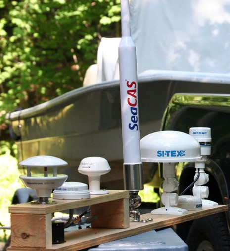
* So I may have been a little jealous about the Bermuda Race last weekend (still don’t know who won), but I did manage to build an antenna farm suitable for my driveway and other test locations. Check it out big size and you’ll also get a peek at my almost new GMC Sierra hooked up to Gizmo, and ready to explore Malaga Island and thereabouts with my daughter tomorrow (which explains yesterday’s screen shot).
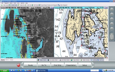
Actually I’ve been watching RayTech 6.0 for quite a while, as I was kindly included in the Beta testing. I think Raymarine really got it right this time. Take a look at the full screen shot, and consider all the cartography it supports. On the left is Navionics Platinum being read off a CF card in a Navionics USB reader; RayTech seems to speedily support every Platinum feature—including blended photo maps (shown), panoramic photos, 3D, port info, tides & currents, etc. (by contrast Navionics own NavPlanner hardly supports any Platinum features, yet). On the right of course is a Maptech raster chart; other Maptech products supported are photo maps (with variable blending) and topos. Finally, you can also read NT+ charts using a C-Map reader.
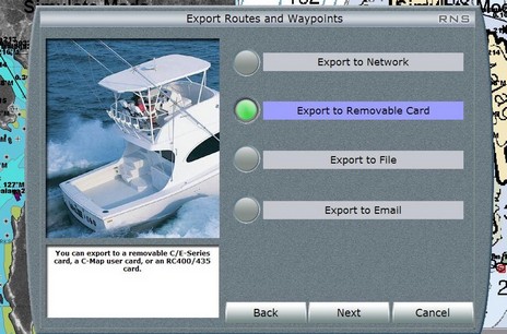
And consider how many ways there are to use RayTech 6.0. You can download it for free (yes, available now), grab some free rasters, and you’re all set to plan routes that you can copy onto a CF card and take to your Raymarine C or E, or email to someone, or whatever (see below, bigger here). Or you can buy a Navionics or C-Map reader and use your plotter charts to plan on, or at least compare to the rasters, again taking the routes to the plotter via card. Or you can license your copy of 6.0, and then a single Ethernet cable feeds it everything that’s on an E Series network (Sirius weather, Navtex, and AIS excepted, for the time being). I’m trying both networked and stand alone versions, as well as the Sirius weather, am impressed by all, and will report further.
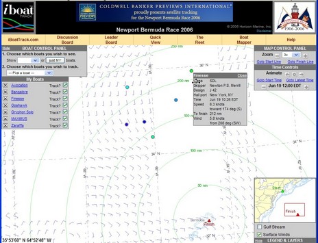
I suspect I’m not the only guy a little mopy about not being in the huge fleet headed out into the Atlantic toward Bermuda right now. In fact, the usually wonderful iboat tracking system, above, seems to be jammed up right now, I’m guessing with gawkers trying to see who started well. Iboat tracking won a Sail FKP Innovation award last year, and the write up by Deputy Editor Josh Adams is available as a PDF on iboat’s home page. Josh, who is now Sail’s Publisher (oh yes, we writers like that!), is racing on the 65’ Reichel Pugh Zaraffa, while Senior Editor Kimball Livingston is aboard the Open 50 Gryphon Solo, and Roaming Editor Charlie Doane is aboard Avocation, a Swan 48 owned by Offshore Passage Opportunities and chartered by some “Aussie lunatics”. In other words, Sail is covering this race very well. Plus Alex on Finesse is business manager of Sail and PMY, and our blog buddy Eli is racing. Shouldn’t I be meeting these boats in St. George to debrief the electronics?
PS, 6/19: iboat tracking has been working pretty well since Saturday afternoon (though you can see on the full screen that the wind overlay is a mite funky right now). Zaraffa is 1st in class (the biggest class) and 2nd overall—way to go, Josh—and even Finesse is hanging in (though promised e-mails failed to materialize).
PS, 6/20, 8am: The light air has really shaken up the usual leaders list, and the 4am unofficial leader board is showing a freakin Swan 56 as 1st overall, Josh 2nd, and Doane (w/ “Aussie lunatics”) an astounding 20th. Can’t wait to see who the real winners will be.
PS, 6/22: I fixed the link above to the “real winners” list, and it’s now almost totally complete. As of last night, there are still some boats out there, like Chase, skippered by Ocean Navigator publisher Alex Agnew. Also discovered that Kimball Livingston has put a couple of good posts about his Gryphon Solo race.
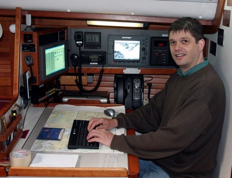
I hear it’s a little foggy in Newport today, but I doubt it’s dampening the excitement about tomorrow’s 100th Bermuda Race. A couple of weeks ago I visited Alex Merrill aboard his dad’s J42 Finesse, above, just before they sailed from her winter berth in Maine (the phenomenal Lyman Morse yard) to Newport. The compact electronics system, much upgraded last winter, features a Raymarine E80 networked with a built-in VEI Marci computer running RayTech 5.0 and displaying on a Big Bay 10.4” monitor. Note the little WiFi antenna at top left in the photo, bigger here. Finesse actually shifted berths while I was visiting to get a better WiFi connection so Alex could download all the weather he wanted for crossing the Gulf of Maine. I’m sure he’s doing something similar in Newport right now, but during the race he’ll be limited to the ultra narrow bandwidth data available via the fixed Iridium and the SGC SSB (no, I hadn’t heard of the SGC brand either, but the Lyman Morse electronics guy is fan). Alex will be updating Panbo during the race, and we’ll be looking at Finesse’s system in a little more depth.