So what do I mean that the new Zeus propulsion system has nerves as well as brains? Well, hooked into the drive controller is an ultra high precision GPS and inertial navigation sensor which feeds it fast updates on the boat’s location along with which way she’s heading, sliding, twisting, rolling etc. Thus the drive gets instant feedback about how well it’s doing what you asked it to do. In other words, if you’re coming alongside a dock and you push the joystick a little bit to starboard, Zeus will take you a little bit to starboard no matter if the current or wind are pushing you hard toward the dock, away from it, or in some other direction. Zeus can do what the very best boat driver does, i.e. observe what the yacht is actually doing in real time, figure out all the forces involved, and compensate for them to get her to go where he wants her to go. Of course the ultimate expression of a totally integrated drive/navigation system like this is its ability to hold station, which seemed rock solid during the demo. It works so well, in fact, that the Cummins guys say they have put Ingenuity next to dock and stepped ashore—no dock lines (though that will never be an advertised feature). That well!
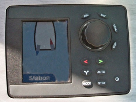
Now it must be noted that the specific navigation sensor hardware being used on the demo is apparently a very expensive Oxford Technologies RT3000 working with private Omnistar differential GPS corrections, which adds a serious subscription expense. But it’s clear that Brunswick’s electronics division is hard at work trying to provide the needed level of precision by the time Zeus becomes a real shipping system. In fact, Zeus may explain why Brunswick picked up MX Marine, which I couldn’t figure out last Spring. The image above shows a Navman/Northstar auto pilot that’s been souped up to work with Zeus’s amazing capabilities (note how the pilot is neatly showing you what the drives are up to as you cast a line, or take a picture, or whatever). It seems obvious that many Zeus boats will be Brunswick hulls with Brunswick drives and Brunswick electronics—all one—which is worth one more Zeus entry, tomorrow.
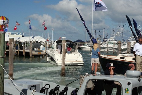
Above is the Zeus demo boat, which has just departed a slip at Miami’s Sealine Marina and now—instead of the normal hard right, hard left exit—is going dead sideways down the channel. Leaving those bow lines neatly on the pilings was also impressively easy—no stretching—because the driver could bump the bow where he wanted it with just a little twist and push on the joystick. Now omni-directional joystick control, typically using twin engines and a bow thruster, has been around for a while, but Zeus is more powerful and much more precise, and eliminating the thruster eliminates the weakest link. Whereas close-quarters maneuvering is about the hardest thing to learn about boating these days, this is a revolutionary development. So how the hell does it work?
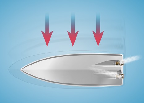
Well, surprise, there is a micro processor involved! Zeus’s control module can steer, shift, and throttle each drive independently…drives which can turn 45 degrees outward and 15 inward, and can do so at a screaming 45 degrees per second. Hence the driver’s simple command to go sideways, or any which ways, results in some complex vector analysis and propulsion commands that only a human trained like a helicopter pilot could pull off (illustrated below). So Zeus is way beyond drive-by-wire technology; it has brains. In fact, it has a nervous system too, which I’ll explain tomorrow.
Maptech’s freeboatingcharts.com is now offering a DVD with all current NOAA raster charts, all Corp of Engineers river charts, and a real charting program for $50. The charts are organised on the disc into 23 ChartKit-style regions, and this deal even includes technical support. The software is Offshore Navigator Lite, the same program that now comes free with Maptech’s printed ChartKits and Waterproof Chartbooks. It’s not great, but it’s not bad either. I’ll try to write more about it soon, as well as the Zeus thing I started! Have a great weekend.
Yesterday a product development manager at a major marine electronics company said to me, “Thankyou for Panbo; you’re making it easier for me to do my job.” That felt good! I also enjoy the international group of enthusiasts who come by Panbo regularly and the fact that so many Google searches (try “Northstar 8000i” or “Si-Tex AIS”, for instance) rank Panbo near the top. That means boaters doing Web research are finding Panbo useful.
At any rate, I sort of spaced out my actual first Panbo anniversary yesterday, but indulge me while I noodle about where this blog could go. I have lots of ideas, like adding: longer form pages where I could republish some of my print work, or yours; in-depth product reviews; a marine electronics ‘wiki’, as in Wikipedia, in which we could all help create a deep and current knowledge base about this field; and perhaps user forums. I look at product niches like digital cameras, and great resources like dpreview.com, and I’m sure that Panbo, or something like it, has room to grow up and really make something of itself.
Of course there are time/money issues! Both Yme—who actually founded this blog—and I are busy with other jobs. In fact, Yme is so busy that he’s decided to drop his publishing role here and I am about to become sole owner of the site. I’m talking to possible part time publishers and also looking for a good Movable Type programmer (anyone?). My goal is to generate some real income from Panbo so I can spend more time creating content. I’m considering straight advertising, sponsorships, even a ‘donate’ PayPal button. Of course I’d love to hear your advice about how to grow Panbo and how to make it a self sufficient business.
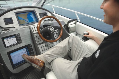
Above is a 42’ Maxum that Brunswick, specifically the Cummins MerCruiser division, was using as a special demo boat at the Miami Boat Show. Obviously (bigger here ) it’s loaded with Northstar’s new 8000i multifunction displays (and, yes, that lower one seemed a bit odd as you could kick it if you were being ‘casual’ like this model). Now I’d love to test the 8000i on the water (especially once the finished system ships in June), but this demo was much more about that fat joystick, and the engines, drives, and electronics it’s attached to, all called Project Zeus. I got to experience it myself and, by golly, it’s a very big deal indeed. The drives are similar to the IPS system that Volvo introduced last year, except that the props face aft (which I, from the bays of rocks and lobster traps, strongly favor). I won’t go into Zeus’s claims of efficiency, low noise, etc., though you might want to check out the press release. What I want to tell you about is how I watched a guy joystick this boat’s bow within a few feet of a day marker and then do a 360 around the mark with the bow always within those few feet. I also saw how you could push the “hold station” button on the Navman pilot and boat would sit exactly in place despite wind and current, and without thrusters. This is really revolutionary stuff, and important, I think, to the future of boating and marine electronics. More tomorrow.
I’ve been posting on Panbo for almost exactly a year now, and one of my first entries was about the sailing version of Airmar’s WeatherStation. While I’m sorry to report that that product still does not exist, the powerboat version does and I’ve been testing one. Above, and bigger here, is a screenshot of the PC software that comes with the ultrasonic (no moving parts!) sensor. This particular screen shows the controls available (left) and also what data can be graphed over time. Clicking on any of those graphs switches it to the gauge-style real-time reading. The software is very easy to use but needs some work; for instance, the wind speeds are graphed to a 0–100 knot scale, which means that low speeds hardly show any differentiation. And wind direction history is not kept, which is something that must be fixed for the coming sailboat version (which won’t have a GPS, but will have an inclinometer supposedly able to correct the wind sensor for heel).
But I quibble. There are a lot of neat ways to use the WeatherStation, well illustrated in its latest PDF brochure. I have most of the setup below working (I just haven’t installed the “Smart” depth/speed/temp sensor yet), and it’s a powerful little network. A PC charting program like CE easily collects wind/GPS/heading/air temp coming out of the optional combiner via USB at 57,600 baud, plus the Furuno RD30 (a very handy device) provides alternate data display, and there’s room to run more NMEA 0183 devices into or out of the combiner. Nice detail: according to the WeatherStation manual (another PDF) the combiner favors alternate GPS or heading inputs over what’s built into the unit. I think that means that the built-in sensors can serve as automatic back ups. Nice!
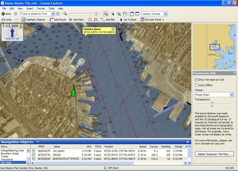
The boat in the screenshot (bigger here) shows the location of my rented fifth floor apartment in Boston’s North End. It’s wonderfully close to the Harbor (and a lot of great Italian food), but does face in the opposite direction, which is probably why I’m not getting a lot of range from my test Si-Tex AIS receiver. The signals, also shown, have to bounce off the eight story building across the street to reach the antenna in my window. Also seen in this screen is the little-mentioned ability of Coastal Explorer 1.1 to download photo maps (and topos) from Terraserver USA and overlay them with variable transparency over charts (in this case an ENC). It’s a nicely executed “bonus feature”, but you do have to be online for it to work, though it does cache the images for later use. Of course, if you buy the Chart Navigator Pro version of CE you get all these photo maps on DVD anyway; but you can’t blend those with charts (maybe a feature in the works?). Showing just north of my apartment is the U.S.C.G.’s big Boston Station. I’m hoping to visit there and maybe get out on a CG vessel, and I’m looking for other similarly ‘productive’ ways to occupy these two months I have to be in Boston. Ideas anyone?
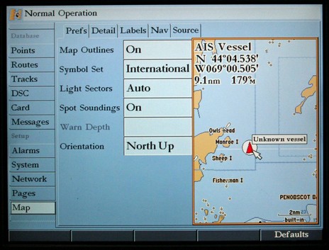
Above, me hearties, is an AIS target plotted on a test Garmin 3120 in my basement last weekend, at least minimally. For instance, the plotter should have been showing the vessel’s name by the time I took this photo (I know it was being transmitted), and the manual shows an AIS subtab in this Map menu that apparently doesn’t yet exist. So I’d say that Garmin’s AIS display is a work in progress, which is probably why the company hasn’t promoted it yet (despite all of Pascal’s prodding). I’ll bet that the feature will get fully developed in future software revs, including CPA and TCPA controls. I hope too that the High Speed NMEA setting used for AIS reception will also be able to see GPS strings, which did not seem to be happening in my test (I was using a SeaCas combo AIS receiver and GPS).
But I had another reason to use this particular photo, bigger here. Trying the 3120 reminded me how neatly Garmin does this Map Setup menu, letting you see the effects of any setting change live in a chart window you can zoom/scroll. It works Great!
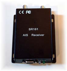
* Panbo reader Gary has a positive report on the Smart Radio SR161 sold by Milltech Marine. Using it with a standard VHF antenna on his 53’ mast, he’s seeing (in CE) ”marine traffic as far away as Port Townsend, which is a fairly straight shot 30 miles north. I could see traffic in Seattle’s harbor, which is only 4 or 5 miles away, but there is a large hill between it and Shilshole. A few ships showed up in Tacoma, 25 miles or so south, but not as clearly – they were blue triangles without names. There are a lot of twists, turns and hills between my location and Tacoma.” He had some problems with a another setup at home, since resolved, but “In all, it is pretty amazing to get all this info from a $200 black box!…It will be a great addition to the GPS, radar, and charting software to use while crossing the Straits of Juan de Fuca in the fog. Now I will know the size, speed, course, and even name of those large dots coming at me.” A guy named Paul is also posting reports on the SR161 at rec.boats.electronics.
* Another Panboid, Jeff, found this low cost dual frequency receiver from a German company called EasyAIS. If you hit the ‘products’ tab at the site you’ll see that they also have an interesting splitter that will supposedly let you share AIS, VHF, and FM on one antenna. Has anyone had experience with EasyAIS gear specifically, and with antenna splitting AIS in general?
* Then there’s the recent plan in the U.K. to built a national infrastructure of AIS listeners, because “AIS technology will form a key building block in an 'e-navigation' system of the future - an internationally integrated, electronic navigational aid that could transform the shipping industry and provide a safer and cleaner marine environment across the world.” Wow…e-navigation.
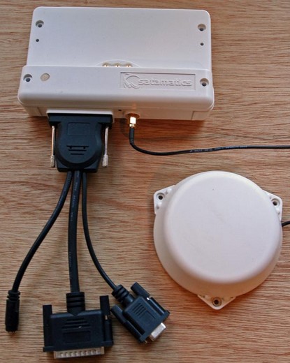
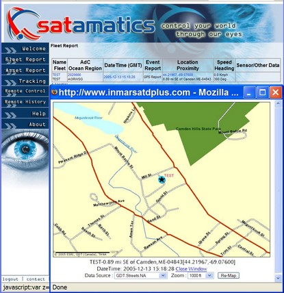
To tell the truth I didn’t even know that there was an Inmarsat D+ satellite data service until I found the Satmatics booth in the far reaches of the Lauderdale Show. Satamatics, in fact, virtually owns this service, operating its own base stations and global tracking network, and making terminals like the 101 above, which it sells into many markets. Now, we’re not talking broadband here, but D+ is capable of moving small amounts of data quickly and reliably. With its low power needs and built-in GPS that means it can track a smallish boat (or vehicle) anywhere (as seen below, and bigger here). It’s also been approved for use as a SSAS (Ship Security Alert System), which would be nice to have non mandated vessels.
But all that’s just scratching the surface. Supposedly the 101 can also do SMS and text e-mail, and includes numerous inputs for monitoring, as well as relays for actually taking action on the boat by (very) remote control. While I think it would be fairly easy for a boater to use a Satamatics terminal just for tracking, like this Australian sailor did, and/or SSAS, the company has not made the other possibilities easy to use. I suspect Satamatics is just too big to develop the neat multifunction boating product that’s possible with this service and transceiver, both of which I understand to be reasonably priced at wholesale. So noodle with me; how could this product be made really useful for boaters by itself or integrated into other marine electronics?


 I won’t go into Zeus’s claims of efficiency, low noise, etc., though you might want to check out the
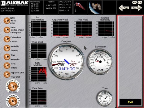

 which is a fairly straight shot 30 miles north. I could see traffic in Seattle’s harbor, which is only 4 or 5 miles away, but there is a large hill between it and Shilshole. A few ships showed up in Tacoma, 25 miles or so south, but not as clearly – they were blue triangles without names. There are a lot of twists, turns and hills between my location and Tacoma.” He had some problems with a another setup at home, since resolved, but “In all, it is pretty amazing to get all this info from a $200 black box!…It will be a great addition to the GPS, radar, and charting software to use while crossing the Straits of Juan de Fuca in the fog. Now I will know the size, speed, course, and even name of those large dots coming at me.” A guy named Paul is also posting
  * Another Panboid, Jeff, found this low cost dual frequency receiver from a German company called