
Settling into Boston, with a few gizmos
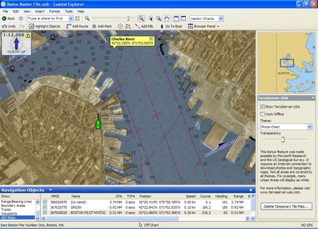
The boat in the screenshot (bigger here) shows the location of my rented fifth floor apartment in Boston’s North End. It’s wonderfully close to the Harbor (and a lot of great Italian food), but does face in the opposite direction, which is probably why I’m not getting a lot of range from my test Si-Tex AIS receiver. The signals, also shown, have to bounce off the eight story building across the street to reach the antenna in my window. Also seen in this screen is the little-mentioned ability of Coastal Explorer 1.1 to download photo maps (and topos) from Terraserver USA and overlay them with variable transparency over charts (in this case an ENC). It’s a nicely executed “bonus feature”, but you do have to be online for it to work, though it does cache the images for later use. Of course, if you buy the Chart Navigator Pro version of CE you get all these photo maps on DVD anyway; but you can’t blend those with charts (maybe a feature in the works?). Showing just north of my apartment is the U.S.C.G.’s big Boston Station. I’m hoping to visit there and maybe get out on a CG vessel, and I’m looking for other similarly ‘productive’ ways to occupy these two months I have to be in Boston. Ideas anyone?
Do you know if Coastal Explorer or Chart Navigator will adopt automatic frequency switching for the Si-Tex/Nasa receiver? And do you have an email address to which you reply?