There are two aspects of the above screen shot that you have probably never seen before. One is the chart itself, which is meant for fishing, not navigation; hence no shore detail or nav aids, but way more bathy data than you’ve ever seen for this area. Navionics calls the card Fish’n’Chip and is giving it away with regular Platinum cards and its new Gold+ cards. It’s all part of their Silver/Gold+/Platinum product strategy, noodled about here and fully revealed here. And note that the screen shot was taken using a beta of Navionics’ much awaited PC planning program, NavPlanner, shipping soon. Here’s the cool thing: I’m in Miami filming two PMY videos about Navionics’s whole chart line and today will my second of trying all the cards aboard a charter sportfishing boat. I have a lot more to report, but no time right now.
Here’s some “what’s on board” perspective: this ‘boat’, technically a raft, is made of just four logs lashed together each day that it’s used. As you fish, the logs soak up water and the ‘boat’ loses freeboard, so when you get ashore you undo the lashing and lay the logs on a rack to dry in the sun. I have no idea how many centuries (millennia?) old this design is, but I saw the type in use all along the south coast of India, sometimes even in surf. No electronics, of course; hell, not even a nail! I took these pictures in October, 1999, a little after dawn in the fishing village of Vizhinjam, just a short walk from Kovalam, in the beautiful state of Kerala. I can still hear the babble: hundreds of fishermen messing with loggers, coming in from a night at sea in an outboard (with one kerosene lantern), and hauling a huge net that had been set into the harbor for the night…all while a mosque at one end of the beach and a cathedral at the other blasted amplified morning prayers. If you ever get a chance, go to this beach at dawn.
Yeah, yeah, a Uniden Mystic that plotted AIS targets would be cool; so would a CVP that was also a Class B AIS transponder (see these comments). But it’s not that easy. An AIS receiver might lose targets if you’re transmitting through its antenna, and a transponder definitely needs a separate antenna. And aren’t all the tuners—2 for AIS, 2 for class D VHF—essentially separate? There’s also the hassle of FCC and European certifications. I do ask VHF makers about such things and sometimes they say, “We’re looking into it.” but mostly they shake their heads. Several times at this show—usually when I was asking obnoxious questions like “When are you adding NMEA 2000 support” or “How about a GPS chip and DSC in a small handheld VHF?”—manufacturers would say something to the effect of “We need more engineers! Got any?” In fact, I learned that Garmin also bid on Lowrance, (it’s in the public record, Raymarine too), which seems more about acquiring engineers than products, which overlap quite a lot. Got any engineers?
Are you old enough to remember Superman on TV? “It’s a bird! It’s a plane! It’s Superman!!!” That’s what came up in my fuddled brain when first presented with Standard’s first-of-its-kind what-the-heck-is-that? VHF and chart plotter combo machine. If you look close, the screen above is an obvious dummy, but I saw the unit running in Miami and was impressed. That screen is a 7” wide style—hi res (800 x 480 pixels) and hi bright. The CVP fully supports C-Map Max and its interface looked quite polished up compared to the old CP series (which wasn’t bad). The radio is full Class D DSC with a 30 watt hailer/horn built in, and you can add two RAM+ or telephone style mics if desired. You can also hang a black box fishfinder on this ($1,100 MAP priced) thing, making it quite the all-in-one for, say, a center console fishing machine or a tuna tower, or a sailboat helm. The designed-in ‘handle’ on the right side might be useful in those places too. Of course all the DSC benefits of interfacing GPS/plotter and VHF come built-in, just add an MMSI to get position with distress call, plot your buddies, etc. By the way, that area of marine communications is about to get a boost as Sea Tow rolls out an interesting new marine operator service called Sea Smart. More on that in few weeks.
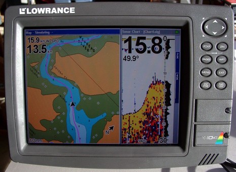
Here’s an interesting question: “I am looking for a combo GPS/Sounder for my dinghy, which will record depth data along the GPS track (so we can go out, find the channel, and then bring the dinghy GPS/Sounder to the mother ship and follow the track/depth data).” I can’t think of any truly portable solutions that would work in a rowboat, but I happen to know that this man’s ‘dinghy’ is actually a center console skiff. And that means that any of Lowrance’s recording GPS/fishfinder units, like say a 5” LMS-332C, might do the job. For years now, Lowrance combo units have been able to record your GPS track and sonar imagery to an MMC/SD card (and now to the 20gig hard drives in some units). You can play chart and sonar back on the display itself, split screen like below, or you can put the card in a reader and watch just the sonar scroll on your PC using free viewing software. The picture below (and bigger here) is me trying this feature a few years ago in some skinny Maine waters, and it worked quite well (note: that’s a Navionics Gold chart, not a Lowrance NauticPath). And, by the way, you can also play the recordings back in the nifty PC Product Emulators that Lowrance also gives away. But all this might be overkill in terms of collecting soundings in a poorly charted anchorage. Does anyone know a neat way to collect a depth/position data stream from a small boat, then display it nicely on an electronic chart?
* Rich Ray sent in a very interesting article at Lectronic Latitude which suggests that Class B AIS transponders will be made mandatory for recreational boats over 34’. I am quite dubious about this, though the article seems well reported. It is true that the U.S. Dept. of Homeland Security sees AIS transponders as a valuable surveillance tool (ID all the good guy radar/AIS targets, and the bad guys are left exposed), but my sources in the Coast Guard say that the strategy is to encourage transponders on smaller non commercial vessels, not mandate them. I believe the USCG has even distributed grant money toward development of inexpensive transponders.
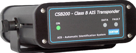
* Meanwhile, the U.K. company Comar has quietly introduced the CSB200, above, which is expected to retail for $1,200. But it’s not shipping yet: “We initially anticipated shipping early orders in March/April; however due to delays in obtaining type approvals this has now been extended to August, for Europe. Once we have obtained approvals in Europe we will then submit for FCC approvals, so realistically product availability in US is probably late fall.”
* And a new outfit, Milltech Marine, has started selling Smart Radio single and dual channel AIS receivers. The single is even less expensive than the Nasa AIS Engine, but looks to be better made (it has LEDs!). A Panbo reader just ordered one, and promises to report back.
* Speaking of Nasa, the folks there are confusing consumers by claiming that their AIS output is NMEA 2000. That’s just not true. I wrote Nasa about this and they say they mean just the 38400 baud speed. But that doesn’t make sense either; NMEA 2000 is faster than that. Knuckleheads!
* Finally, AIS targets were all over the Miami Boat Show, but probably the biggest single boost for the technology was Raymarine showing a lot of writers and marine electronics dealers how it works out on the water, on E and C Series displays.
“Will report on the Boat Show this week as possible.” Yeah, right! Seems like I regularly think I can accomplish more than I can actually accomplish. I even planned to work on several articles—all due very soon, if not past due!—while I was there. So the bummer is that I saw all sorts of great stuff I’d like to Panbo about, but posting will be darn thin until I get through this deadline cycle (and another trip to Miami and Bimini next week).
I must go down to the sea again, in a modern high-tech boat, And all I ask is electric, for comfort while afloat, And alternators, and solar panels, and generators going, and deep cycle batteries with many amperes flowing. I must go down to the sea again, to the autopilot’s ways, And all I ask is a GPS, and a radar, and displays, And a cell phone, and a weatherfax, and a shortwave radio, And compact disks, computer games and TV videos. I must go down to the sea again, with a freezer full of steaks, And all I ask is a microwave, and a blender for milkshakes, And a watermaker, air-conditioner, hot water in the sink, And e-mail and a VHF to see what my buddies think. I must go down to the sea again, with power-furling sails, And chart displays of all the seas, and a bullhorn for loud hails, And motors pulling anchor chains, and push-button sheets, And programs which take full charge of tacking during beats. I must go down to the sea again, and not leave friends behind, And so they never get seasick we’ll use the web online, And all I ask is an Internet with satellites over me, And beaming all the data up, my friends sail virtually. I must go down to the sea again, record the humpback whales, Compute until I decipher their language and their tales, And learn to sing in harmony, converse beneath the waves, And befriend the gentle giants as my synthesizer plays. I must go down to the sea again, with RAM in gigabytes, and teraflops of processing for hobbies that I like, And software suiting all my wants, seated at my console And pushing on the buttons which give me complete control. I must go down to the sea again, my concept seems quite sound, But when I simulate this boat, some problems I have found. The cost is astronomical, repairs will never stop, Instead of going sailing, I’ll be shackled to the dock. I must go down to the sea again, how can I get away? Must I be locked in low-tech boats until my dying day? Is there no cure for my complaint, no technologic fix? Oh, I fear electric fever is a habit I can’t kick. And software suiting all my wants, seated at my console And pushing on the buttons which give me complete control. I must go down to the sea again, my concept seems quite sound, But when I simulate this boat, some problems I have found. The cost is astronomical, repairs will never stop, Instead of going sailing, I’ll be shackled to the dock. I must go down to the sea again, how can I get away? Must I be locked in low-tech boats until my dying day? Is there no cure for my complaint, no technologic fix? Oh, I fear electric fever is a habit I can’t kick. ###
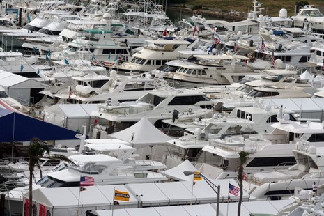
Hey, someone sent it to me! My reaction: read it out loud, it’s pretty darn good. And there are some snippets of truth in there, but the electronics cat is way out of the bag. For instance, contemplate the fleet of floating technology I see out my hotel window (telephoto).
* Happy to report that FreeNavCharts.com—torn into pretty fiercely here last month—really has cleaned up its act, and is now an informative Web site and a useful service.
* I’m told that Lowrance does acknowledge that certain rocks are missing from NauticPath charts, and says they will reappear in NauticPath version 2, coming out in about 6 months. Also added will be drying heights, seabed composition, anchorage areas, obstructions of uncertain depth, and more. Lowrance does not usually offer an upgrade path for cartography (it is very reasonably priced, after all) but is “considering” a special policy regarding NauticPath.
* The new 3.1 version of MacENC will now properly display those same rocks, as shown here. And I’ve heard from The Capn folks that they’ve not only solved their ENC rock display issue but have also figured out ways to display certain other valuable ENC chart details that “no one else is showing”. Examples are coming. This whole experience has made me a little leery about ENCs, if not all vector charts, but Panbo does indeed rock!
Enroute to Miami today; will report on the Boat Show this week as possible.
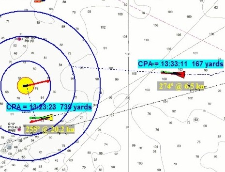
That yellow vessel with the bold range rings is Capt. me off Boston a couple of days ago, or at least a simulated Capt. me. But the AIS targets were real! That’s because at least this beta version of The Capn lets you get AIS targets off the Internet, in fact comes set up (see below) to get all the receivers being streamed by SeaLinks (which includes Penobscot Bay, my home waters). The feature is not something you’d use at sea, but it sure is useful for seeing how an ECS handles AIS targets. For instance, I really like the way the Capn plots the actual CPA; for the target ahead it’s that little (167 yard) dotted under the the 2nd range ring. It helped me understand better what the pass was going to look like, and being prudent, I decided to turn another 20° right.
Notice, by the way, how The Capn lets you turn off anchored and docked targets. It makes sense but watch out. When I checked out Penobscot Bay this afternoon, the towboat Penn #4 was doing 8 knots off Monhegan but broadcasting “At anchor”, while Penobscot, doing .01 knots at a pier in Rockland, was labeled “Underway under power”. Garbage in, garbage out!


 , anchorage areas, obstructions of uncertain depth, and more. Lowrance does not usually offer an upgrade path for cartography (it is very reasonably priced, after all) but is “considering” a special policy regarding NauticPath.