The Garmin media team was busy last night, distributing a stack of complicated press releases and a pile o’ product shots, all to describe some 20 new units that were introduced at METS today (and will go on sale next March). Here are the bullet points I’ve gathered so far:
* New BlueChart G2 (next generation) charts feature 3D perspective, tides and currents overlay, and other enhancements, and a slew of new plotters, plotter/fishfinders, and network multifunction displays (like the 3206 above, bigger here) come preloaded with all U.S. coastal G2’s. (NOAA’s freebie policy strikes again!)
* But G2 is a two tier product, sort of like what Navionics is up to, and G2 chart cards add more data like detailed coastal roads, more POIs, and color aerial photos of critical areas. Garmin says that U.S. cards will start at $199, “far less than competitors”. (But I don’t know what that means exactly). G2, by the way, is not compatible with older plotters, except the 3000 series, but older BlueCharts will work in new plotters.
* Garmin has a new network called CANet, which can connect the smaller 292, 392, and 492 plotters with two new black box fishfinders or the new 398 full fishfinder. It sounds like a CANbus variant but is 1 megabit (?). The GSD-22 bb is Garmin’s “first digital sonar, allowing for more precise target separation and depth performance” and also supports Garmin’s MarineNet (Ethernet).
It’s going to be interesting to see how all these products stack up. I’m wondering, for instance, what Garmin’s version of 3D perspective looks like, and whether G2 will also come on CD. And, of course, pesky observers like Panbo reader R.O. are asking “what about NMEA 2000”. More to come, to be sure.
PS It will also be interesting to see who picked up DAME awards at METS today; this is one of the better innovation competitions out there, I think. And, by the way, Jeff Hummel is at METS and says he’ll write a Panbo guest blog on his findings.
At the NMEA show, Maretron showed off a prototype of this ultrasonic wind sensor that also measures air temp, barometric pressure, and relative humidity. In other words, the WSO100 Weather Station Outdoor is quite like Airmar’s WeatherStation. Neither, in fact, is actually a shipping product yet, even though Airmar’s was introduced at the 2004 NMEA show (the power boat model is supposedly very close, and is now detailed in a .pdf at Airmar’s Web site). Airmar’s first unit, for about $1,000, will talk in NMEA 0183 and will include an electronic compass and GPS so it can calculate true wind speed and direction. Maretron’s will cost around $600 and will need heading and SOG info from the NMEA 2000 network to do the True calculations. Airmar plans to eventually introduce a 2000 WeatherStation and Maretron may very well do an 0183 version of its sensor, which, by the way, it engineered from scratch. I hope to try both when possible, and figure that having two ultrasonic wind sensors on the market (beside the French original) will be good for consumer awareness (and a healthy competition).
The good folks who make GPSNavX and MacENC just announced a $40 (plus $5 s/h) DVD containing all NOAA U.S. coastal charts, including Alaska, Hawaii, and the Great Lakes. They’re in BSB 3 file format and should work fine with any Mac or PC charting program that reads BSBs—which is just about all of them. Note that the BSB 3 format is not encrypted. Note too that these are the same charts available for free download at freeboatingcharts.com (but what a hassel it would be to order, download, and unzip all of them).
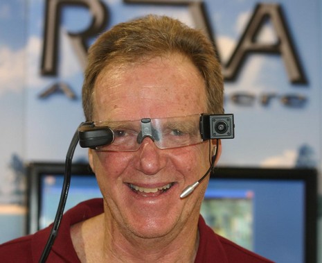
Yup, it’s funny to imagine paying $3,500 to wear this gizmo around your megayacht, but if it works as advertised I’ll bet there’s a small market for it. The idea of ReVA—Remote Video Assistance from/to Anywhere—is to troubleshoot a problem by voice and video with an expert ashore. That’s a tiny color monitor near my right eye so I can aim the camera that’s at my left temple. Clipped to my waist is a little WiFi video/audio server and loaded into the yacht’s computer is “tunneling” software designed to get the 30 frames per second .mpg stream smoothly ashore via the vessel’s Internet connection. ReVA handles the shore end, either routing the problem to its partner Nauti-Tech or sending it on to 3rd parties. ReVA may seem a bit far fetched but many megayachts already have fast, always-on Internet connections these days, and you can imagine that they may also have problems keeping all their megacomplex systems working (wait till you hear about the entertainment rigs I saw!).
We interrupt the normal new electronics programming for a brief rant. I just read this in the November issue of Boat.U.S., reportedly the largest circulation boating magazine on the planet (and generally quite good):
“But before you have visions of hitting ‘print’ on your computer and getting a high resolution quality chart, boaters need to understand the terms ‘raster’ and ‘vector’ charts. A raster chart is essentially a snapshot of a paper chart, composed of a bunch of dots, like a newspaper photo. While the resolution is not good enough for printing, it’s fine for a computer program and screen display.”
Say what!?! Everything printed is a bunch of dots, and the native resolution of most raster charts is 254 dots per inch, very darn close to the 300 dpi standard for quality glossy magazine images. Just about any decent charting program can print rasters very nicely at full scale (the only real trick is printing from the file, not the screen image).
The BoatU.S. article, titled “Charts Go PC”, starts with a decent explanation of NOAA’s new free RNC (and ENC) download policy. But then it veers into shaky territory like the above and various other misunderstandings about vector/plotter charts. It’s a shame because boaters are confused enough about marine electronics, software, digital charts, etc. that the “expert” magazines should be going out of their way to provide accurate information.
I wouldn’t rant on this subject—and risk sounding like an arrogant ass—except that I regularly come across electronics errors in the boating press. Lord knows, for instance, how many times I’ve seen Ethernet and NMEA 2000 treated as though they were essentially the same (not!). At any rate, take care to treat printed words with appropriate caution (and if you’re an editor please consider having technical articles from uncertain sources double checked by an expert or two).
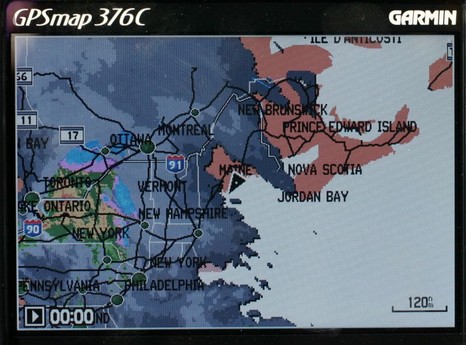
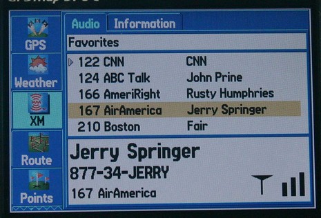
I would have posted earlier today, except that fooling with this Garmin 376C vividly reminded me (above, and bigger here) that the spell of dry, sunny weather was about to end. So I spent some hours winterizing the fleet, all the while watching the clouds thicken up from below and above. I could also see an animation of all that rain moving across New York state, plus the lightning strikes, the frontal lines, pressure gradients, wind predictions, buoy reports, etc. etc. It is phenomenal how well you can see all this info on the 376’s little screen. The display itself is exceptionally bright and detailed, and Garmin has also done a good job at letting you view the weather data mixed together or one element at a time. And, get this, I was also listening to XM radio (below). I’ve been trying the 376C intermittently over the last month or so, and am very, very impressed. It really makes sense in terms of carrying your XM weather and audio subscriptions with you on land or sea. The only con I can think of is that BlueCharts have gotten pretty expensive relative to the competition, but maybe that will change.
The Garmin 276C was one of my 5 Sail magazine “editor’s picks” for innovative, important marine electronics introduced last year. I’m working on my 2005 picks right now, and the 376C is definitely a contender. If you have suggestions for other hardware or software that should be on the list, please let me know.
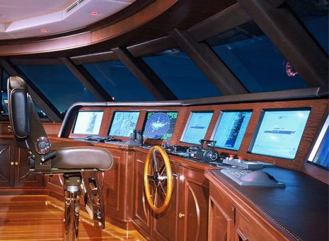
The deer hunters now stalking the woods where I live rate a trophy kill by the “points” in its antler “rack”. I’m guessing that the owner of Janie was thinking along the same lines when he ordered up the nine (9!) screen glass bridge partly shown above (all VEI 20” inset displays with a touch screen master control such that any input can go to any screen). The charter brochure even rather oddly includes a version of this same photo, except with TV sports scenes photoshopped onto every screen (as if the yacht’s 61” and 50” plasma screens weren’t enough). Apparently the owner is quite the sports fan.
Me, I was more interested in all the other gear and software that Janie’s captain could display, like: two Furuno black box radars, both Nobeltec and Transas charting sytems, a brace of EMI monitoring screens, plus feeds from umpteen onboard cameras and a NVTi long-range night vision system (that’s apparently had leaking problems during Janie’s multiple Atlantic crossings). It was real kick to get a tour of this helm with the yacht’s able skipper plus the gentleman from Yachtronics you oversaw the install. My huge frustration was that my Canon Digital Rebel chose this moment to half break. I could take pictures but couldn’t change lens, and therefore couldn’t use the amazing 14mm aspherical lens I’d dragged along, quite capable of showing you all 9 of those screens at once. Damn! Maybe I should have bought a higher quality camera in the first place, or had an extra body along. It was a reminder of how the guys in charge of massively complicated electronics like Janie’s must learn to think. Which is probably why I saw the same brands over and over again on the several megas I toured. I’ll detail more of what I saw soon.
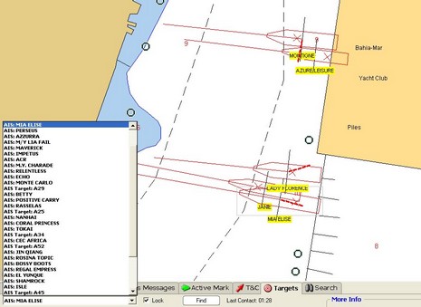
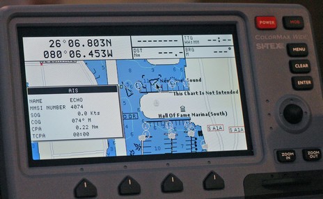
The above snip from a Nobeltec VNS screen (full size here) shows how some of the megayachts tied stern-to at the Ft. Lauderdale show looked AIS-wise. There are obviously a few errors either in the vessel dimensions or GPS locations (the red “X”s) or the underlying chart, but mind you this is a very zoomed-in view. I saw lots of boaters looking at screens like this and realizing what AIS can do for them. I also got to go aboard several of the megayachts and can tell you that the crews on those boats are also impressed with the technology. The Nobeltec exhibitors were using the Nasa/Si-Tex receiver with a regular VHF antenna tied to the top of their booth inside a giant steel framed tent, and were still getting some 30–40 targets within about a ten mile radius. The Si-Tex ColorMax plotter shown below was similarly set up and getting lots of targets.
The show, by the way, was better attended by exhibitors and customers than I had guessed, and I’m glad I went. More to come.
Whoa, things are happening even faster than enthusiastic yours truly thought possible. For $500, Maptech’s new Chart Navigator Pro (CNP) give’s you 13 (13!) DVDs containing NOAA’s entire portfolio of U.S. RNCs and ENCs, plus all of Maptech’s accessory cartography—photo maps, harbor panoramas, topos, bathy maps, pilot books, and information databases. But the real surprise inside is that Maptech ditched its aging, non-quilting, non-vector charting software in favor of Coastal Explorer. The name has changed, but CNP is CE 1.1 with nothing taken out and Maptech’s decent 3D contour engine added. CNP gets introduced today at the Fort Lauderdal Boat Show and will supposedly be in stores next month.
PS, 11/7: Thanks to Greg’s comment for a head’s up that Maptech has launched a new site, freeboatingcharts.com, where you can download all the U.S. RNCs you want. I don’t quite understand why Maptech is doing this before NOAA has a system in place, but it works fine. First you select the charts you want, then the site packages them up in a self executing zip file and notifies you when it’s ready for download. It only took maybe a half hour for me to receive the 15 charts that cover my area in all scales.
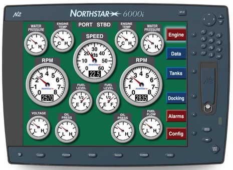
I got a peek at this display during NMEA , and I’m looking forward to going deeper in Lauderdale. What’s the docking display? How much control does the user get over engine alarms? Are detailed diagnostics also available? This Northstar 6000i is (theoretically) connected via a gateway to a Mercury inboard or outboard engine equipped with SmartCraft, a CANbus data networking and control system with many similarities to NMEA 2000. The big difference really is that SmartCraft was developed by Brunswick and is being used by its New Technologies group (MotoTron, Northstar, Navman, et al) mostly in boats build by Brunswick. Other companies like Airmar, Onan, Dometic, Xantrex, and DNA Group have gotten involved, but SmartCraft is essentially driven in a top-down, business-like way. By contrast, NMEA 2000 sometimes seems like chaos. Maybe that’s why there are currently lots more SmartCraft boats out there than NMEA 2000 ones. It may be a parallel universe, but if it works well for you…well, cool. Then again I’ve heard that there are some downsides to SmartCraft worth discussing one day.
Note that the 6000i above is a new 12” model, meaning that you can now get these networked multifunction displays in a phenomenal five sizes—15”, 12”, 10.4”, 8.4” and 6.4”—which is great for folks designing a multi display helm like this (put together, unfortunately I think, before the 12 or 15 inch models materialized).


 called CANet, which can connect the smaller 292, 392, and 492 plotters with two new black box fishfinders or the new 398 full fishfinder. It sounds like a CANbus variant but is 1 megabit (?). The GSD-22 bb is Garmin’s “first digital sonar, allowing for more precise target separation and depth performance” and also supports Garmin’s MarineNet (Ethernet).
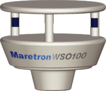 At the NMEA show, Maretron showed off a prototype of this ultrasonic wind sensor that also measures air temp, barometric pressure, and relative humidity. In other words, the

 Whoa, things are happening even faster than enthusiastic yours truly