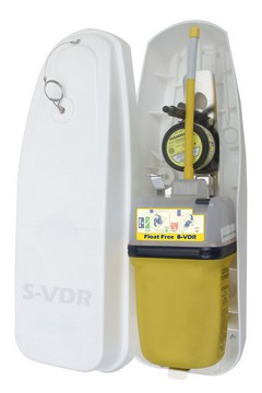
It looks and acts like an EPIRB, but is, in fact, a simplified voyage data recorder (S-VDR). “Like black boxes carried on aircraft, S-VDRs enable accident investigators to review procedures and instructions in the moments before an accident to help to identify its cause. The RapidTrack S-VDR is designed to interface with bridge information systems and to record and maintain a retrievable record of the ship's nautical, technical and safety data. The RapidTrack S-VDR is designed to interface with bridge information systems and to record and maintain a retrievable record of the ship's nautical, technical and safety data. The S-VDR will automatically deploy once the vessel has sunk to a depth between 1.5 to 4 meters. The beacon then floats to the surface and automatically begins broadcasting GPS coordinates to aid in location and retrieval. There isn’t any info on ACR’s site besides the press release, and the unit isn’t FCC approved yet, but interesting technology, eh? S-VDR is now mandatory on certain commercial ships too.
(Also, head’s up, expanding ACR recently sent out another release seeking job applicants. “We need help in filling several newly created key positions in engineering, sales and technical support”.)
I’ve never much liked the practice of inserting insulators in a sailboat’s backstay to create an SSB antenna; I want my backstays in one piece, thank you. Thus the Gam/McKim Split Lead Single Side Band Antenna looks like a much more sensible idea. The new design (bigger drawing here) fits over the stay, is easy to install or remove, and promises better performance with less likelihood of corrosion. Plus it’s “priced to compete with conventional backstay insulators (including swaging costs)”. Nice.
PS, 7/18: Rumor has it that Sail SSB expert Gordon West tested this antenna and found that it worked as well as an insulated backstay, even when fitted over the grounded stay of a steel boat. I’ve also seen reports that it many cases (depends on wire fittings) it is actually less expensive than the traditional insulator set up. Very nice!
A bonus of my trip to Annapolis was getting to try Maptech’s third generation i3. I first saw this system back in 2001, when it was being developed as the Sea Ray Navigator (and it’s still going on many new Sea Rays under that name, despite parent Brunswick’s own move into electronics). Last summer I enjoyed a live demo of the second generation system, which Maptech had begun to market on its own as i3. By then the developers had added radar plus optional touch screen versions of Weather Channel Marine and SkyMate. Now Maptech owns the contractor that actually builds the i3 hardware, and the new Type 3 is a significant upgrade. The screen is more stylish, more colorful, and brighter, and the software flys. Plus there are many interface improvements (besides the 3D fishfinder option). In the screen above (bigger here), notice how the radar range rings can be shown on the 3D screen to make better sense of relative scales. Notice too how the 3D is automatically exaggerated to make the good, and bad, sections of this relatively shallow river (hey, I live in Maine) obvious. Look at how well the radar is synched to the chart, despite the fact that there is no electronic compass in this particular install and we’re doing 26 knots (which is why the depth sounder isn’t reading; the transducer needed better fairing for high speed). It’s not shown but Type 3 also lets you remove the side menus, or make critical info semi transparent, so you get more chart on the 12” screen. And, finally, there’s now a 15” screen version too. i3/SRN is not just a unique concept; it’s an evolving family of functions.
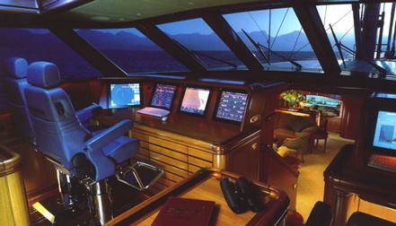
Monitoring and control systems can potentially do anything. Once you have a system of sensors, cable backbones, PCs, screens, and so forth performing the core task of collecting and distributing information and system commands, well heck, why not blend in security, entertainment, communications, inventory/maintenance management, digital documentation…whatever. A case in point is Hyperion (above), the 157’ super yacht built in 1998 by Royal Huisman for the legendary Silicon Valley entrepreneur Jim Clark. Clark had to start a small company called Seascape Communications to create the system he envisioned, and what a humdinger the resulting “Genisys” is. 24 onboard computers monitor 50,000 data points and display on 22 touch screens throughout the vessel. Clark and his crew could mind and manage everything from windshield wipers to ballast transfer pumps to e-mail wherever they wished onboard. Clark could even “cruise” the yacht by satellite from his den in California (or his airplane), leading to the waggish comment that it was the world’s largest remote control toy. And guests had their own screens mounted into berth-side drawers so that they can amuse themselves with the system’s 1200 CD’s on hard disk, 400 DVD’s in changers, world band tuners, and masthead cameras!
Since then, Clark had Royal Huisman build him the even larger yacht Athena, launched last fall, with more Seascape software on board. Now he’s announced the formation of CommandScape, which sounds like Seascape repurposed to automate large homes as well as yachts. Clark was the subject of the wonderful biography The New, New Thing, which begins with a hysterical description of Hyperion’s trail run in rough weather—failing computers, seasick film crew, et all…a must read excerpt here).
I was out testing in bright sunshine Saturday morning, and the screen on the Garmin 192C stood up very well. In fact this is the worst image I got, and it’s still quite readable (bigger here…note the glare, reflected elbow, and gunk on screen—real world factors you’ll rarely see in ads or articles). The 192 is the new unit that comes with all U.S. coastal charts in memory and ready to use. They really are all there, along with large area charts of places like the Bahamas, a good world map, and tons of port information. It is true that you can not use these charts with Garmin’s MapSource to do planning on a PC, but the no-PC-needed simplicity will be a plus for many users; even updating the charts will be done with a card. The only other con I could detect is that the find function is slowed down somewhat by the massive amount of data it has to search through. Besides the brighter, more color saturated screen, I noticed numerous subtle improvements in Garmin’s already effective tabbed interface. I’d guess the 192 will appeal to smaller boat owners wanting ready-to-use simplicity and flexibility (trailer north or south for vacation, get a card for lakes), not to mention cruisers who do big sections of the U.S. coast and want a backup to integrated and/or PC systems. The 192 comes with internal or external GPSs, and there’s a 198 version with fishfinder. Garmin won’t say if it might bring the all-US-charts-onboard strategy to other models, but what do you think? (Especially as Lowrance is offering this feature on many units).
Big power outage here earlier this morning…coffee bean grinder no grind, DSL modem no blink…I’m definitely off my stride. I’m declaring this an OFI Friday, and will soon be off to fool with the fleet. If you’re stuck inside somewhere, you might want to picture yourself strolling down a dock with this Flintstone tablet PC in hand (for full effect, include the GSM whip antenna not screwed onto this prototype). I saw it displayed at a show once, and the developer’s site is still up, but I’ve never seen one in the field. In my fantasy, the case is carbon black and the boat I’m strolling toward is the Wally 118. Oh yeah.
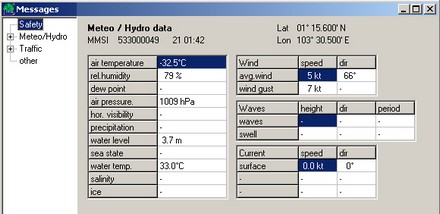
There’s an interesting thread about the Chinese-built SmartRadio AIS receiver (click ENG upper left when you get there) over at rec.boats.electronics, but I would caution readers that the $200 price cited seems to be introductory wholesale. (The dual channel SR 161 needs a distributor). A well informed poster named Holger notes that it “receives and processes all AIS messages, not just some like the NASA/Si-Tex Engine”. Holger is a principal in a German company called Yacht AIS which has developed two AIS plotting programs. The professional version can display some of the more arcane AIS messages like the weather station shown above. I’m making it a habit to ask folks at major marine electronics brands if they’re working on AIS (quite a category at Panbo these days). Every one says something like “oh yeah!”, and some are quite interested in how the Class B AIS standard will turn out.
PS: Yacht AIS is associated with a Swedish company, True Heading, which has good .pdf manuals for the SR 161 and its own AIS RX Yacht listener here (but no pricing).
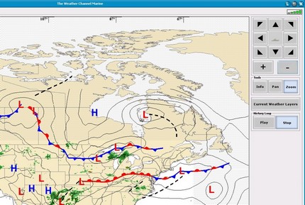
I missed the fact that WSI, the company behind Weather Channel Marine, inked a deal with Sirius Satellite Radio in March. "Our goal is to offer the gold standard of marine services”. This is good news, as it should heat up the competition between WSI’s service, now only available on PCs (including Maptech i3) via a single satellite, and the XM Marine Weather that can be had either on a PC or on Garmin network plotters. I’ve been watching the “live” weather category closely, and have tried at least the early PC and Garmin products, and was very impressed with how much detailed and macro weather sense I could get easily. In fact—odd timing—I was trying out a pretty good GRIB weather tool last night, but without the Nexrad radar and frontal line predictions, I missed the wet squall line that’s passing through here this morning! Above, and bigger here, is part of an old Weather Channel Marine screen that just suggests how you can see animated Nexrad combined with current and forecast fronts…very effective. A face off between giants Sirius and XM as providers of top notch U.S. coastal marine weather should lower subscription and hardware costs, open up new platforms, and really make boaters aware of this valuable service.
One of the most interesting back stories in the marine electronics world is how the planet’s largest boatbuilder, Brunswick Corporation, bought up a series of companies like Navman and Northstar and formed a division called Brunswick New Technologies (BNT). The move sent shock waves through the big brands used to selling lots of product to Brunswick units like Sea Ray and Boston Whaler, or to their dealers. The presumption was that Brunswick boats would soon all come with electronics built, branded, and supported by the mother corporation. Navman, in fact, has the first color plotters and fishfinders to support SmartCraft, Mercury Marine’s (i.e., Brunswick’s) own version of NMEA 2000 CANbus. But I’ve been told that each Brunswick boatbuilder, sometimes each big dealer, is free to make their own decision about electronics packages, and there seem to be a variety of brands on new Brunswick boats. What do you all see out there? And why did BNT just acquire MX Marine, a small company solidly focussed on commercial AIS and dGPS, often under the Leica label? What’s the plan?
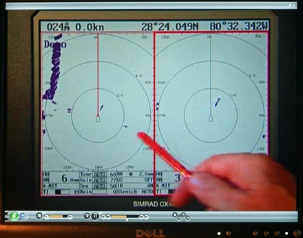
This weekend’s mail included Simrad’s “Navigation Tutorial” DVD, which is pretty darn impressive. Of course there is some ‘sell’ to it, but there’s also some sharp footage of boats and extensive, well done explanations of just how Simrad’s multifunction Navigators work. (That’s the narrator’s hand in the picture, not mine, explaining dual radar ranges). This DVD is excellent for anyone who owns a Simrad, or is interested in one, and it’s absolutely free, including shipping. The order form is on the Simrad USA home page.

 It looks and acts like an EPIRB, but is, in fact, a simplified voyage data recorder (S-VDR). “Like black boxes carried on aircraft, S-VDRs enable accident investigators to review procedures and instructions in the moments before an accident to help to identify its cause. The RapidTrack S-VDR is designed to interface with bridge information systems and to record and maintain a retrievable record of the ship's nautical, technical and safety data. The RapidTrack S-VDR is designed to interface with bridge information systems and to record and maintain a retrievable record of the ship's nautical, technical and safety data. The S-VDR will automatically deploy once the vessel has sunk to a depth between 1.5 to 4 meters. The beacon then floats to the surface and automatically begins broadcasting GPS coordinates to aid in location and retrieval. There isn’t any info on ACR’s site besides the press release, and the unit isn’t FCC approved yet, but interesting technology, eh? S-VDR is now mandatory on certain commercial ships too.
 I’ve never much liked the practice of inserting insulators in a sailboat’s backstay to create an SSB antenna; I want my backstays in one piece, thank you. Thus the
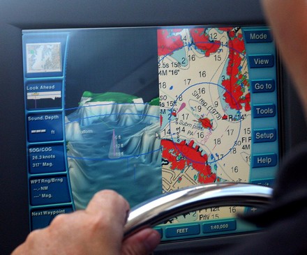
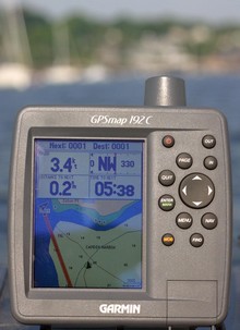 I was out testing in bright sunshine Saturday morning, and the screen on the Garmin 192C stood up very well. In fact this is the worst image I got, and it’s still quite readable (bigger
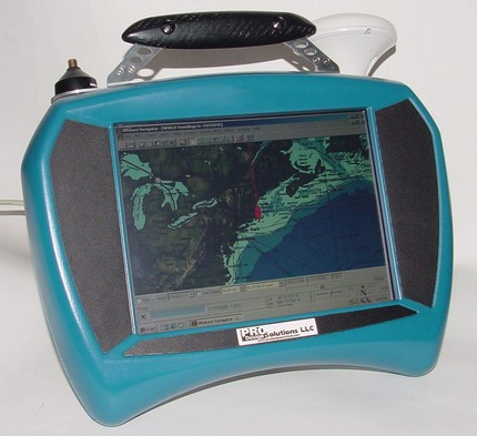
 One of the most interesting back stories in the marine electronics world is how the planet’s largest boatbuilder, Brunswick Corporation, bought up a series of companies like Navman and Northstar and formed a division called Brunswick New Technologies (