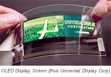
“Let us now praise consumer electronics—the iPod, Palm Pilot, the computer and even the not-so-lowly TV set. Why? Because while virtually everything else in yachting becomes more costly, marine electronics consistently provide more value for your money, in large measure due to the use of the billions of dollars invested in consumer product technology.”
That’s how Chuck Husick begins his latest at Yachtingnet, an interesting look at new trends. Chuck’s piece led me to learn more about Organic Light-Emitting Diode (OLED) screens, like the prototype shown. Note that someone at Yachtingnet, probably not Chuck, mistakenly captioned the Airmar WeatherStation as wireless; it’s not, though it’s a fascinating product.
For a while now, a free registration at AISlive.com was possibly the best way to appreciate how valuable this anti-collision transponder technology actually is…short of, say, getting in trouble crossing the English Channel in zero visibility. AISlive has numerous coastal receivers listening for AIS messages, which it then charts on the Web in nearly real time. The screen shot below shows Amsterdam Harbor a few minutes ago. I’ve clicked on a boat called Unfurled and learned that it’s an 34m sailboat, one of the growing number AIS equipped yachts; Yme could probably stroll over and check it out! I can also go to the Straits of Dover, New York Harbor, and lots of other places and imagine how fabulous this information would be if I were cruising there right now (I wish).
But the IMO never contemplated Web broadcasting when it developed the AIS standard and some ships (and megayachts) apparently aren’t that pleased to see themselves so publicly tracked. There was talk of shutting AISlive down, but a much better resolution has been achieved. On May 3, what you see now on the site will become an expensive service limited to commercial and government subscribers. It’s an understandable change and the great news for us “private users/ship enthusiasts” is that “We have decided to create a public website (at our own cost) which is similar to the current AISLive but delayed by a minimum of one hour. We will not be charging for this service and hope you continue to enjoy the website.” Thank you, AISlive.com.
ConnectFest was one especially notable electronics event at a 2005 Miami Boat Show chock-a-block with the new and notable. NMEA rented a side room where something like 40 devices made by 12 different manufacturers were all connected into one NMEA 2000 backbone…and talking to each other. Members of the trade, press, and public all seemed dazzled by the possibilities. My photo shows a Raymarine E120 displaying data from multiple sources (I’m not even sure which engine, as there were several on line, but you’d know on your own boat). ConnectFest will make another appearance at the upcoming annual meeting of the Radio Technical Commission for Maritime Services (RTCM). I suspect that 2005 is the year that the unfortunately named NMEA 2000 standard really gets rolling.
Lowrance started talking about its new NauticPath electronic charts last fall, but the details — cost, which plotters they’ll run on, and “where the heck did Lowrance get them?” — are still resolving themselves. You may still find Web references to regional cards at $99 apiece, but it’s definite now that Lowrance will ship (very soon) all U.S. coastal charts on one card for $109 retail! And a new page at Lowrance says that the Great Lakes, Bahamas, Puerto Rico, and USVI are also included! The same page indicates that most every plotter in Lowrance’s fast-growing line will run these charts, though a firmware upgrade may be needed. So one sweet possibility is backing up a boat’s plotter system with an inexpensive waterproof handheld loaded with charts, and also able to play MP3 music! By the way, at a Miami Boat Show press conference, Lowrance allowed that NauticPath is based on the same Transas chart database that Nobeltec and Garmin licensed as the foundation of their electronic chart formats.
Lowrance has a phenomenal number of new products this year, and the specs on many of them will likely prompt more exclamation points here.
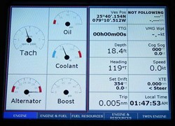
Isn’t it neat that a lot of boaters gleefully invent stuff to improve their vessels? A fairly extreme example is one Roger Jones who put together his own elaborate boat monitoring system, wrote the necessary software too, and then created a site where anyone can download this software for free and read Roger’s well written instructions about how to assemble the hardware from off-the-shelf parts. Roger’s screen shots indicate that Version 2, currently in “beta”, can not only mind batteries, AC power, pumps, lights, and NMEA 0183 nav data, but can also display weather buoy data (from where I don’t know) and video. Nice work, Roger! (By the way, I learned about this because Roger posted a message on our Electronics Forum at PMY).
Panasonic calls it a Toughbook MDWD, an awkward acronym for Mobile Data Wireless Display. Nobeltec simplified it to WND for Wireless Nobeltec Display. Whatever the name, this touch screen portable display is nifty technology, able to extend the usefulness of a “down below” PC to most anywhere on deck. Once you’ve added a WiFi transceiver (easy) and the included MDWD/WND drivers to the PC, you can run it remotely with a stylus or even a finger tip. The weather resistant wireless display even comes with a wrist strap. I tested one a couple of years ago and was impressed with how readable the 8.4” screen was, even in difficult light. Now Nobeltec is offering a new MK2 model ($1,900) that is purportedly even brighter, and has a longer battery life. Nobeltec is also now stocking extra battery packs and an AC adapter.
Garmin’s new 192C plotter and 198C plotter/sounder come with full detail BlueCharts for all U.S. coastal waters, including Alaska and Hawaii, loaded in non-volatile memory and ready to use! This is remarkable news because until now you had to also buy either chart cards or a CD with which you burned your own chart card. Either way, getting charts for, say, a trip down the East Coast could cost more than the total $964 price tag on the 192C, and was more hassle. One possible downside of the pre-loaded charts is that you won’t have a card or CD that you can use with a backup plotter. It’s also not clear how Garmin will update these charts, or if they will work via USB for planning on a PC. I look forward to trying one of these five-inch diagonal units, which also boast “a new look and feel”, in the near future.
Garmin’s charts-included strategy, which will likely come to other new models as they roll out (just guessing), is only one of several major changes in the world of electronic charts that I’ll try to touch on here over the next few weeks.
Ben Ellison here, pleased to introduce myself as the new editor of Panbo.com. Yme Bosma did a fine job of starting this weblog last year, and I’m pleased to report that he’s staying on to manage and grow the technology behind it. Between us, we hope to take advantage of this new medium to create a lively window into the fascinating and fast-moving world of marine electronics.
As for me, I’m a life-long boat guy — cruiser, delivery captain, navigation instructor, almanac editor, sucker for odd vessels, etc. etc. — who’s lived on the coast of Maine since buying an old 40’ wooden sloop here in 1971. Nowadays I’m the Electronics Editor for both Power & Motoryacht and Sail magazines (who owns and enjoys both kinds of boats). I’m also an advisor for Marine Electronics Journal and write columns for Voyaging and Maine Boats & Harbors. I’ve watched yacht and work boat navigation go from RDF and celestial to satellites and PCs, and am enthusiastic to see where the heck the technology is headed next. Yme and I hope you’ll join us as a reader and/or contributor to blog about it!

 “Let us now praise consumer electronics—the iPod, Palm Pilot, the computer and even the not-so-lowly TV set. Why? Because while virtually everything else in yachting becomes more costly, marine electronics consistently provide more value for your money, in large measure due to the use of the billions of dollars invested in consumer product technology.”
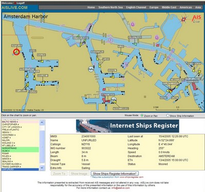
 ConnectFest was one especially notable electronics event at a 2005 Miami Boat Show chock-a-block with the new and notable. NMEA rented a side room where something like 40 devices made by 12 different manufacturers were all connected into one NMEA 2000 backbone…and talking to each other. Members of the trade, press, and public all seemed dazzled by the possibilities. My photo shows a Raymarine
 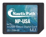 Lowrance started talking about its new NauticPath electronic charts last fall, but the details — cost, which plotters they’ll run on, and “where the heck did Lowrance get them?” — are still resolving themselves. You may still find Web references to regional cards at $99 apiece, but it’s definite now that Lowrance will ship (very soon) all U.S. coastal charts on one card for $109 retail! And a new
 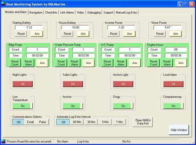 Isn’t it neat that a lot of boaters gleefully invent stuff to improve their vessels? A fairly extreme example is one Roger Jones who put together his own elaborate boat monitoring system, wrote the necessary software too, and then created a
 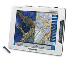 Panasonic calls it a Toughbook
 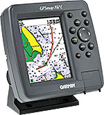 Garmin’s new
  Ben Ellison here, pleased to introduce myself as the new editor of Panbo.com. Yme Bosma did a fine job of starting this weblog last year, and I’m pleased to report that he’s staying on to manage and grow the technology behind it. Between us, we hope to take advantage of this new medium to create a lively window into the fascinating and fast-moving world of marine electronics.