A chap named Wayne B. is very happy with his new boat WiFi set up over at rec.boats.electronics. He says he’s “hitting low power, indoor access points at least 300 yards away,” and expects to get commercial outdoor APs at over a mile. Wayne’s using an external USB-powered NUB-362(EXT) radio connected with 30’ of Hawking CoAX to a 9dB Hawking omni-directional antenna that’s 30’ off the water. Those links go to online sources and the whole kit adds up to around $185, plus, per Wayne, “an adapter to go from an SMA connector to type N coax, also available at CompUSA”. Cool, and less expensive than purpose built marine gear we’ve seen here and here. But I couldn’t get the NUB362’s specs to open and am not sure this will work with my son’s Mac. Anyone know a sure fire way to improve a Mac’s WiFi range?
PS 7/31: There’s another interesting discussion of Wayne’s WiFi rig going on at rec.boats.cruising. Also the whole bundle of hardware is available cheaper at Netgate (though it turns out the radio is only 200mW, not good enough for Jeff). And thanks, everyone, for Mac WiFi booster ideas!
My photo is none too great, but at least at bigger size you can make out the hardware components. Port Network’s approach to marine WiFi is not a fixed high dB antenna but rather minimizing the distance between an independent, well amplified WiFi radio and its relatively small antenna. The wiring is further simplified by ‘injecting’ power into the 25’ Ethernet cable. The result: a waterproof, portable WiFi bridge that you deploy on deck when you anchor or tie up. I’ve tried it now in Boston and around Camden Harbor and can say with assurance that it locks in way more WiFi signals than my little Linksys PCMCIA card. It finds available access points automatically, too, though you can use a browser to get into its extensive software, below, and survey what APs are in sight.
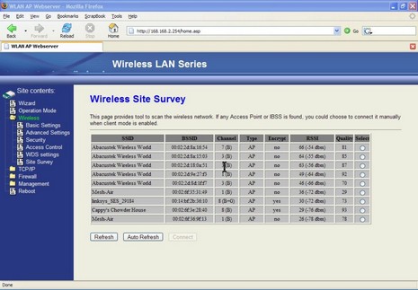
The screen shot, incidently, shows how two commercial providers, Abacus Technology and Mesh-Air, have blanketed Camden Harbor with WiFi, and right now the latter is giving it away. Thank you, Mesh-Air. I could barely get two of those APs with my regular card, but I must say I’m curious how this thing would work with a 9dB antenna. On the other hand, it would quite handy as is in several hotels and other situations I’ve been in over the last year. (Here’s a PDF describing the MWB-200 in more detail, and here’s its online store blurb).
PS, 6/15, Port Networks comments:
To answer your speculation about how it would perform with a 9dB antenna: great, when it worked at all. Here's why...
Omni antennas like these are passive devices, achieving their gain by focusing the signal passing through them. They redirect signal that would go up and down, using it to push farther out to each side. (Imagine someone taking a ball of dough and squeezing it down into a pancake. The radius of the pancake is considerably larger than the radius of the ball, and that's the gain.) The tradeoff for higher gain is less coverage -- relatively little signal is being sent above and below that horizontal beam. With a very high-gain antenna, the beam is so flat that alignment becomes critical. If the antennas on either end aren't in exactly the same plane, then they won't even communicate. We chose a 5.5dB antenna to provide a balance between gain and a wider beam. A 9dB antenna would provide twice as much gain, but if the boat rolled, or the antenna wasn't at 90 degrees to the path between the two radios, etc., the signal might be lost entirely.
P.S. I should mention that the above applies primarily to omni antennas. Another way to get gain without giving up too much beamwidth is to use a directional antenna, akin to the reflector inside a flashlight. We will be introducing a second model with a directional antenna shortly. By virtue of its directionality, it will have to be aimed, and you'll therefore need to know the location of the access point to which you want to connect, but for those people who are in the situation of trying to connect a long way within their own marina, it will offer twice the gain of our current model.
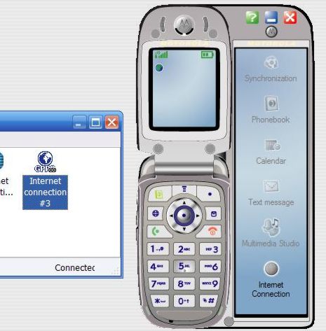
I’m happy to report that GSM phones not only do voice calls in midcoast Maine (finally), but also data. The bit of screenshot above shows a program called Motorola Phone Tools Deluxe 4.0, which can set up an Internet connection quite easily (though I did have to call Unicel for an ‘apn’ address because it’s not one of the many presets). Once set up, it’s just a matter of plugging the phone into a standard mini USB cable and hitting that lower button. It shows a speed of 230 Kbps (though it doesn’t feel that fast) and it logs the amount of data passed. This bodes well for checking my email when I’m beyond local WiFi access points. The software, by the way, also does well at backing up the phone, synching it with selected Outlook calendar and contact info, and making your own wall paper and ringtones (the long intro to UB 40’s “Rat in me kitchen”, if you must know…and, sure, you can have a copy
). Plus the phone charges via the USB cable.
Meanwhile, I’ve continued to experiment with GYMsim. It works fine in Boston, on my phone and also on my daughter’s unlocked Sidekick, but does not seem to work with my local Unicel GSM service. The voice mail is nicely done, and you only pay the base rate (.39 Euros a minute) to listen to them (unlike some cards where you’ll pay roaming fees both for the getting and listening to the message). Best test: I handed the package to a friend flying to Copenhagen on Friday, then called the Liechtenstein number today. GYMsim is working fine for him, and he’s already figured out how to query his remaining balance and “top up” at GYMsim’s site.
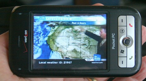
The impressiveness of the above, bigger here, was no doubt heightened by how BIG the weather was around Boston today. I was supposed to go boating on a 44’ Sea Ray but even a few hours tied up in a very protected marina felt heroic given the volume of wind and rain. The project was interesting and I’ll tell you about it tomorrow, but today I’ll just show you the wild and crazy phone one of the guys pulled out. That is the Weather Channel playing on that Verizon XV6700 and it looked and sounded quite good. I was tickled a few weeks ago just to see just static Nexrad on a phone; this TV feed included not just animated radar and sat imagery but a live forecaster (as long as high speed EvDO is available). And it’s source was not some Web site but rather the owner’s own home TV setup which is equipped with a Slingbox, able to serve whatever channels he already pays for out to the Web where he can watch them even when he’s not home, even when he’s rolling around on a boat. The software is SlingPlayer Mobile and apparently it can even control a Tivo type recorder. So beyond live Weather Channel are a lot of other intriguing possibilities.
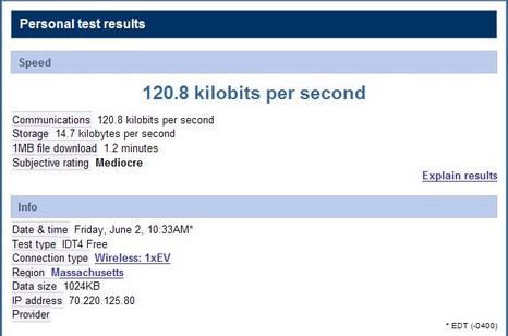
If you ever travel the Boston to New York corridor, you might want to try LimoLiner, a high-end, 28–seat bus that runs several times a day from a Hilton next to the Prudential Center to another Hilton at 53rd and 6th Ave. I’m aboard right now, and this thing is wired! I’m listening to CNN through a pair of noise cancelling earphones and there’s a fairly new DVD movie playing on the other flat screen in my area. I’m also using an onboard WiFi network which in turn is using a Verizon cellular data connection, a setup that looks attractive for boats too, as we’ve discussed before. I don’t know if the particular Verizon radio on this LimoLiner supports high speed EvDO (well covered in a recent PC World), but I doubt it as I haven’t seen really high speed performance even as we passed through downtown Hartford. On the other hand, I’ve had a fairly decent connection—as seen above, and using 1x technology I think—most of the trip (CNN has stuttered some too), pretty impressive at around 60 MPH. Maybe this bodes well for a boat cruising along the coast hereabouts. By the way, I learned that Verizon is the data provider from the voyage attendant, who also served lunch and a snack. Not a real liner but a really nice bus. Have a great weekend.
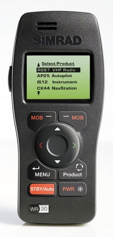
It made sense to me that Simrad’s WR20 RemoteCommander shared an innovation award with the Northstar 8000i at the Miami boat show. It uses Bluetooth to wirelessly connect (“up to” 300’, as they say) with a boat's SimNet (aka NMEA 2000) network, and Simrad has equipped it with custom messages able to duplicate nearly every button push on all its SimNet-equipped devices. (These are the proprietary messages I was talking about here, and a good example of how they can be used innovatively). Potentially you can use this remote to power steer with your autopilot, zoom your chart plotter, change channels on your VHF, just about anything. Plus, if you do have the Simrad RS80 Series VHF that's SimNet enabled, the remote can also be a wireless handset (the Bluetooth audio going directly to the radio, not through SimNet). The remote can also display one to four lines of data from many sources on the network, including non-Simrad sensors. And finally, it is supposedly ready to work with Simrad equipment that hasn’t even been developed yet, though I don’t understand how.
By the way, Simrad’s purchase of Lowrance seems to be a done deal. It’s interesting that both companies have done a lot with NMEA 2000, though in different ways. I wonder how their product strategies and lines will be merged, if at all.
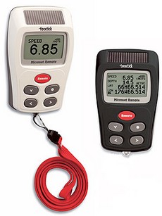
At METS, the U.K. company TackTick—a prior DAME winner for its Micronet wireless instruments—introduced these remote displays. Like the Micronet fixed displays, they’re solar powered and, using a Universal Wireless Interface, can show most any NMEA 0183 data, besides, of course, what’s collected with Micronet sensors. I’m just now realizing how powerful this Interface could be—capable of, say, data networking GPS, PC, another manufacturer’s instruments/sensors, and Micronet. In fact, TackTick even supports proprietary data sentences created on the boat’s PC and then displayed as desired on the Micronet screens (pdf here). It sounds like a savvy sailor or developer could use this to create a very sophisticated instrument system.
Speaking of which, Sailing Anarchy put up a fascinating piece on the super high end sail racing instrumentation that B&G is capable of these days. Note that it is apparently written by a B&G employee, but nonetheless…wow.
Here’s wishing all the Yanks in Panbo world a wonderful Thanksgiving holiday. It’s spitting snow here in Maine, perfect for holing up with friends, family, and a lots of good food. There’s much to give thanks for, but let’s include gizmos too. Needed they’re not, but aren’t they fun?
Yup, it’s funny to imagine paying $3,500 to wear this gizmo around your megayacht, but if it works as advertised I’ll bet there’s a small market for it. The idea of ReVA—Remote Video Assistance from/to Anywhere—is to troubleshoot a problem by voice and video with an expert ashore. That’s a tiny color monitor near my right eye so I can aim the camera that’s at my left temple. Clipped to my waist is a little WiFi video/audio server and loaded into the yacht’s computer is “tunneling” software designed to get the 30 frames per second .mpg stream smoothly ashore via the vessel’s Internet connection. ReVA handles the shore end, either routing the problem to its partner Nauti-Tech or sending it on to 3rd parties. ReVA may seem a bit far fetched but many megayachts already have fast, always-on Internet connections these days, and you can imagine that they may also have problems keeping all their megacomplex systems working (wait till you hear about the entertainment rigs I saw!).
I’m a long time fan of the PDA charting program Memory Map, which is also sold as Maptech Pocket Navigator, and think that its developer, Richard Stephens, is one hell of a programmer. It’s no great surprise then that Richard has mastered mini PC navigation, even while overnight racing aboard a wickedly wet Corsair 28R trimaran (In fact, it was so wet, at one point we had a 2’ long fish flapping around in the cockpit!). But it’s good to know that a coder is out there getting his butt soggy (getting to be one of my favorite blogs), and it surely is interesting to hear about his set up:
I used a PDA for navigation (of course). Itwas connected by Bluetooth to a GPS and to a cell phone in the cabin, which was in turn connected to a Digital Antenna signal booster and 4' antenna. The PDA was an iPaq 4700, in a Otterbox 1900 hard case. I wear the PDA most of the time, strapped to my body with bungee cord (under my PFD belt so it does not flap around). It is turned off when I am not actively navigating, to save power. I also wear a Garmin Foretrex on my wrist, programmed with the route and strategic waypoints [using Memory Map either on the PDA or a PC].
The PDA runs Memory-Map for navigation, using the full detail of NOAA raster charts, with all weekly NTM corrections applied. I used the cellular internet connection to access weather information from NOAA. The real-time buoy/weather station reports, weather radar images, and the ETA wind model. were all extremely useful at different stages of the race. All of these were accessed just using the web browser on the PDA.
Richard and the rest of the Flight Simulator team won first in class in their latest race, the Mackinac. How geek cool is that?
I was a little stunned this morning to discover two very interesting and ambitious marine weather services that seem to have sprung up fully formed, but without my knowledge! SailFlow and FishWeather are sister services, each offering tailored weather products either graphically via the Web or a WAP enabled cell phone (there are lots), or via a regular voice call. The services boast their own weather sensors covering a lot of the U.S. coastline, plus their own meteorologists and even computer modeling programs (in addition to public resources, of course). It turns out that both are the spawn of WeatherFlow, a company which has spent 15 years building a “national coastal mesonet with a presence in over 20 states…The WeatherFlow staff of engineers, meteorologists, and IT professionals are dedicated to increasing the understanding of the complex nature of climate within the coastal zone.” I intend to try out at least each service’s free month trial Web subscription. By the way, Eli of EliBoat—whom I had the pleasure of meeting last week—has been using WSI live satellite weather, which is a whole other animal than SailFlow. He posted some comments yesterday.

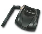 A chap named Wayne B. is very happy with his new boat WiFi set up over at rec.boats.electronics. He says he’s “hitting low power, indoor access points at least 300 yards away,” and expects to get commercial outdoor APs at over a mile. Wayne’s using an external USB-powered NUB-362(EXT) radio connected with 30’ of Hawking CoAX to a 9dB Hawking omni-directional antenna that’s 30’ off the water. Those links go to online sources and the whole kit adds up to around $185, plus, per Wayne, “an adapter to go from an SMA connector to type N coax, also available at CompUSA”. Cool, and less expensive than purpose built marine gear we’ve seen here and here. But I couldn’t get the NUB362’s specs to open and am not sure this will work with my son’s Mac. Anyone know a sure fire way to improve a Mac’s WiFi range?
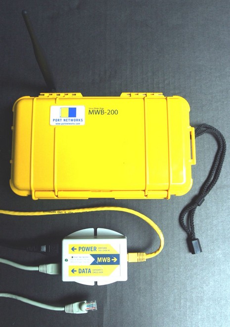
 At METS, the U.K. company TackTick—a prior
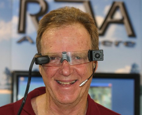
 I’m a long time fan of the PDA charting program
 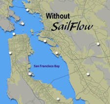 I was a little stunned this morning to discover two very interesting and ambitious marine weather services that seem to have sprung up fully formed, but without my knowledge!