Aug 26, 2005
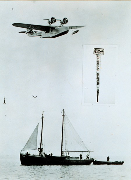
Hurricane Katrina whacked south Florida fairly hard yesterday and now it looks likely that she’ll power up and smack the northwest section of the state early next week. Per usual, there’s an extraordinary amount of data and valuable prediction information at the National Hurricane Center’s web site. Hurricanes are truly meteorological loose cannon, but it is amazing how far our ability to forecast them has advanced. I got to tour the NHC facility in Miami in early 2004 and was bowled over by the high levels of technology, data i/o, and brain power. That was the year that NHC’s back testing program indicated that their forecasting was good enough to begin issuing 5 day track predictions, which have no doubt saved lives and property since. By contrast, observe above how hurricane warnings were delivered to sponge boats off St. Pete, Florida, in 1938 (from NOAA’s online photo library).
Now, no idiot U.S. Senator (carrying water for a few private weather companies) is going to stop NOAA from distributing hurricane information, but, as you likely know, Senator Santorum of Pennsylvania does have a bill in process that might severely limit its ability to share less critical information. BoatU.S. has just posted a good editorial on the issue. Following one of its links, I found and used an easy e-mail form to register opposition to the bill with my senators. Why don’t you?
Update, 8/28: Naturally I’m curious if Katrina could reach Maine with any force, and I now see that the NHC has a new series of ‘experimental’ wind graphics that are quite valuable. This one shows me that the models now predict a 5–10% probability of over 50 knot winds on Thursday. Hmmmmm. Note that it can be animated if you click on ‘loop’.
Jun 9, 2005

I joke about my often over-the-top test boat, but check this guy out! While the topophone looks like a sensible idea for improving our natural stereo audio reception (i.e., ears) so as to get better bearings on ship horns and buoy gongs in the fog, it must have freaked the passengers a bit. The image is the logo of a small company that’s developed a topo mapping application for Smart Phones. It appears to have some interesting features, like to ability to send/plot positions via SMS, but it also has a tough competitor in Maptech’s Outdoor Navigator.
May 2, 2005
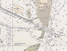 OK, I’m obsessed with charts, but I’m not the only navigator thus afflicted. Last week I used a snippet of a wonderful 1685 chart that’s available on the Net, and promised to tell more. The source is the U.S. Library of Congress Map Collection. The LOC has scanned scads of cartography at very high resolution for your viewing and downloading pleasure. You’ll see several categories, none of them “nautical charts” per se, but you’ll find all sorts once you dive into the search engine. Shown here, and larger here, is a bit of a 1921 chart of Miami. It’s interesting as an early example of color use, and also because it shows a Miami Harbor that’s damn shallow and missing some major features like Fisher Island and the whole cruise ship dock area.
You can zoom into the detail of these charts nicely on the LOC site, especially if you have a fast Web connection, but there’s a problem if you want to download one for further perusal or printing. Many are in an unusual format called MrSID that no standard graphic program I know of can read. The solution is IrfanView, an excellent freeware (or “beggar ware”) program created by a young Bosnian named Irfan Skiljan. IrganView can turn this 6.6 meg .sid file of Miami into a 90 meg .jpg file that would print nicely full size. The LOC offers some maps and charts for areas outside the U.S., but if there are richer sources I'd sure like to hear about them.
