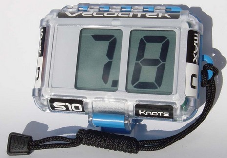
Two digits, two buttons, two modes…one purpose. The Velocitek S10 is a GPS that’s been waterproofed and simplified so that those crazies riding kite boards, hydrofoil moths, etc. can track speed and VMG. Either is displayed at a one second update rate. In speed mode the right button gives you absolute max, the left your 10 second max, while in VMG mode the same buttons set the up and downwind marks. The S10 can also log 10 hours of data at 2 second intervals for downloading ashore using the USB port inside the box. You can have your data in the GPX format—probably the most universal, and definitely compatible with the freeware program GPS Action Replay, which is especially designed for reviewing your day’s speed runs, even a whole race if everyone carries logging GPS’s. Or you can use the .kml format to overlay your track on Google Earth. That’s what excited our boy Ed about the Velocitek, but now—thanks, everyone—we know that he can get info from most any GPS to GE.
Here’s a useful and inexpensive gadget that was just introduced by the good folks at SetSail.com. Just a little bigger than a pack of gum, it will apparently “record and store high and low temperature for 100 days, 100 hours, or 100 minutes”, thus helping a boater “optimize box temperature for best trade-off in food longevity vs. temperature” (not to mention power consumption).
The family’s giddy after the Thanksgiving feast, and so yours truly is showing off his new (birthday present!) Pentax Optio W20 by making it take pictures while dipped in a glass of water. I’ve been fooling with this “ultracompact” camera for a couple of weeks now and think this review from down under is on the mark. And the W20 suits my tastes better than the Olympus Stylus 720 I tested last spring; the USB port is a standard ‘mini’ style, the LCD seems brighter, and at least I can see what speed/F-stop the thing is using. It also takes amazing VGA 30fps QuickTime movies, using some sort of digital stabilization. But I am curious about Canon’s new PowerShot SD800 IS, which has real image stabilization (I like taking snapshots in natural low light), and quite possibly better image quality. Below—and cropped, but full pixels, here—is a shot taken in Amsterdam overcast (F3.3/1/400th/ISO 64/auto everything). Nice canal-side digs, what?
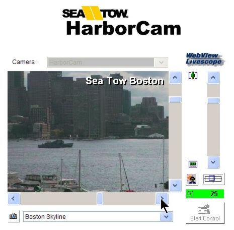
It’s a pleasing coincidence that the best harbor cam I’ve ever come across happens to be in East Boston looking right at the waterfront where I’ve been staying recently. Not that this isn’t a fascinating harbor for anyone to peep around. If you have Java on your computer, you can take control of the camera and pan/zoom from the outer roads (left), all the way across downtown, and into Charlestown. There’s almost always something going on. I visited Sea Tow Boston yesterday, got a ride on one of their boats, and interviewed head man Steve Winkler. I’ll share some of the good stuff I saw and learned next week; have a nice weekend.
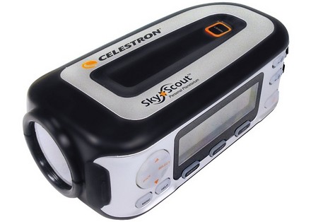
The 2006 CES (consumer electronics) Innovations Honorees are up, and among them is this darned interesting “personal planetarium”. Apparently you can point the SkyScout at any of 6,000 celestial objects, press a button and it will deliver audio “commentary on the object and its history”. Or it can locate heavenly bodies using illuminated arrows in the viewfinder. How? “SkyScout utilizes patented technology that combines data from sensors measuring both the magnetic and gravitational fields of the Earth, along with internal GPS and a substantial celestial database.” There’s more info at Celestron, but no pricing so far.
Now, maybe a celestial navigator could use this gizmo to help with the tricky job of identifying stars at twilight, but there aren’t many active celestial navigators left and they tend to frown on gadgets. Which is all too bad. I think that one of the fabulous side benefits of being at sea or in a remote anchorage at night is an uncluttered view of the heavens. And a fabulous side benefit of learning to use a sextant is an understanding of celestial mechanics. It makes you feel very small…in a good way.
I really am intending to do some research on universal remotes, the bane of many a yacht (and home). But meanwhile some handy fellow dreamed up this model. I wonder how many other guys got it e-mailed to them today? And how many put it on their Christmas list?
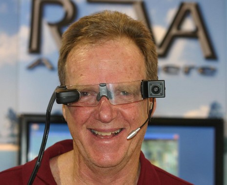
Yup, it’s funny to imagine paying $3,500 to wear this gizmo around your megayacht, but if it works as advertised I’ll bet there’s a small market for it. The idea of ReVA—Remote Video Assistance from/to Anywhere—is to troubleshoot a problem by voice and video with an expert ashore. That’s a tiny color monitor near my right eye so I can aim the camera that’s at my left temple. Clipped to my waist is a little WiFi video/audio server and loaded into the yacht’s computer is “tunneling” software designed to get the 30 frames per second .mpg stream smoothly ashore via the vessel’s Internet connection. ReVA handles the shore end, either routing the problem to its partner Nauti-Tech or sending it on to 3rd parties. ReVA may seem a bit far fetched but many megayachts already have fast, always-on Internet connections these days, and you can imagine that they may also have problems keeping all their megacomplex systems working (wait till you hear about the entertainment rigs I saw!).
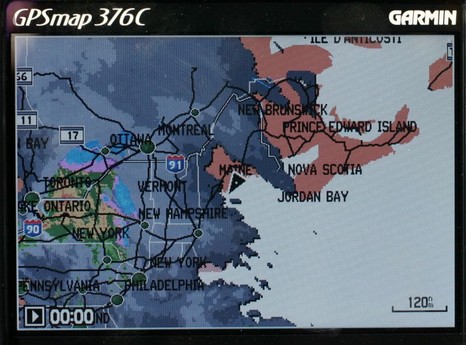
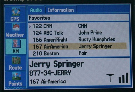
I would have posted earlier today, except that fooling with this Garmin 376C vividly reminded me (above, and bigger here) that the spell of dry, sunny weather was about to end. So I spent some hours winterizing the fleet, all the while watching the clouds thicken up from below and above. I could also see an animation of all that rain moving across New York state, plus the lightning strikes, the frontal lines, pressure gradients, wind predictions, buoy reports, etc. etc. It is phenomenal how well you can see all this info on the 376’s little screen. The display itself is exceptionally bright and detailed, and Garmin has also done a good job at letting you view the weather data mixed together or one element at a time. And, get this, I was also listening to XM radio (below). I’ve been trying the 376C intermittently over the last month or so, and am very, very impressed. It really makes sense in terms of carrying your XM weather and audio subscriptions with you on land or sea. The only con I can think of is that BlueCharts have gotten pretty expensive relative to the competition, but maybe that will change.
The Garmin 276C was one of my 5 Sail magazine “editor’s picks” for innovative, important marine electronics introduced last year. I’m working on my 2005 picks right now, and the 376C is definitely a contender. If you have suggestions for other hardware or software that should be on the list, please let me know.
I’ve been trying this Navman M300, the marine model in a new line of small GPS “Sport Tools” designed to strap to your arm while you windsurf, skate, ski, run, or walk. It delivers speed, heading, distance covered, lap times, etc., but not position or “go to” guidance. And it will not interface to a PC for data collection or waypoint passing. Both interface and tightly defined purpose are KISS (keep it simple, stupid) ideas, largely I’m guessing to differentiate the Tools from the various Garmin Foretrex and Forerunner models that dominate this niche. There are only two buttons and about six choices for the text screen (which is small but readable in all daylight conditions). The firmware for some models seems to have especially valuable features—like the way the ski model leaves the lift segments out of your speed averages and distances—but personally this marine model doesn’t excite me (learning how Richard Stephens uses his Foretrex did, but that’s me). I’m also dubious that “reliably water resistant” is good enough for wind surfers; I know that when I used to do it I’d spend a good deal of the time thrashing about while submerged up to my chin! Then again I would like to know how blindingly fast I was going when I had it together. By the way, the 19 knots max speed above was on my bike, going down a steep hill. I need to exercise more.
Update, 9/2: My doubts abut the windsurfing model may be off base. I’ve now learned that they were used successfully for the Maui Speed Challenge (yes, Navman was a sponsor, but these are the top guys and wouldn’t tolerate a product that didn’t work well).
Given that it’s notoriously hard to photograph a video screen, this is a fair image (bigger here) of what I was seeing yesterday in about 20’ of water using Splashcam’s Deep Blue camera. Plus I should note that Camden Harbor is a bit murky due to the river that dumps into it (and maybe some other dumping, like aboard visiting yachts). I could actually see that lobster trap somewhat better than the photo shows, and when I aimed straight down (with the camera surfaced, via a simple adjustment strap) starfish, shells and annoyed crabs were very sharp and colorful...and fun to see for the first time since I gave up diving. It was also simple as pie to hook Deep Blue to the Raymarine E120, which can handle 4 cameras. As you can see, you can even name the video inputs (as I’ve done with an interesting aft facing camera I’ll write about soon). Plus there are a lot of picture adjustments behind that “presentation” soft key. But dangling electronics in salt water is hard service. Deep Blue seems very well thought out and built, but the double O rings on one of its lights apparently failed in 50’, and the innards don’t look very happy today. In fact, it’s hard to blame on Splashcam as the design uses Pelican MityLite xenon flashlights rated to 250’, which seems like a smart idea (and Pelican offers a “forever” replacement policy). Another camera I took out didn’t work at all, but that’s another story.


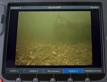
 Plus I should note that Camden Harbor is a bit murky due to the river that dumps into it (and maybe some other dumping, like aboard visiting yachts). I could actually see that lobster trap somewhat better than the photo shows, and when I aimed straight down (with the camera surfaced, via a simple adjustment strap) starfish, shells and annoyed crabs were very sharp and colorful...and fun to see for the first time since I gave up diving. It was also simple as pie to hook Deep Blue to the Raymarine E120, which can handle 4 cameras. As you can see, you can even name the video inputs (as I’ve done with an interesting aft facing camera I’ll write about soon). Plus there are a lot of picture adjustments behind that “presentation” soft key. But dangling electronics in salt water is hard service. Deep Blue seems very well thought out and built, but the double O rings on one of its lights apparently failed in 50’, and the innards don’t look very happy today. In fact, it’s hard to blame on Splashcam as the design uses Pelican