Unlike last year, or last May, this morning’s GMDSS Task Force meeting seemed to yield good news about Class B AIS in the USA. The FCC has finally granted a waiver so that the various units already approved by the USCG can be sold and used even while further rulemaking takes place. The waiver needs to be reviewed by the Interdepartment Radio Advisory Committee (IRAC), but FCC representative Ghassan Khalek said that would be done in “a matter of weeks, not months”. And publication in the Federal Register will not be necessary; the moment IRAC grants its blessing, CG and FCC approved AIS B units can be sold and used. Why did I use the fudge word “seemed” in the first sentence? Well, a year ago Mr. Khalek told me that FCC Class B approval would be quick once the CG was done. So I double checked that “matter of weeks” quote with him as he exited the meeting. He nodded yes, smiled, and murmured a compliment about Panbo’s AIS coverage. Cool.
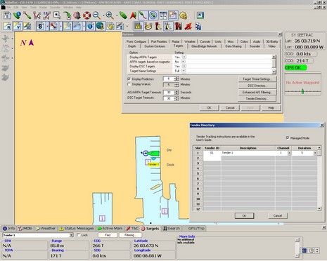
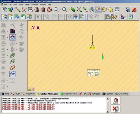
Well, my entry on how Rendez-vous tender tracking uses AIS message conventions seems to have confused even some AIS savvy folks (sorry, Del). To be clear, Rendez-vous will not show up on anyone’s screen unless that screen is connected to a specific network of Rendez-vous radios. Rendez-vous just uses the AIS data structure so that plotting software does not have be modified to see the tenders in a network. Get it? I think it clever, but the folks who developed the Seetrac Tender Tracking systems aren’t so sure:
Tender tracking systems, like the Nobeltec/Seetrac combo discussed here last year, are a bit exotic (even a bit mockable). But I’ve seen the captain of a big charter yacht worry over a ditzy guest out on a PWC, plus I see how over-the-top some mega yacht tenders are getting (like the Vikal Limo). In fact, when I was in the British Virgin Islands last spring, it seemed like every big, really fine center console I saw turned out to be the “little” boat often towed by one much bigger. In other words, tender tracking can be serious business, and I think the new SeaCas Rendez-vous system looks to be a powerful solution.
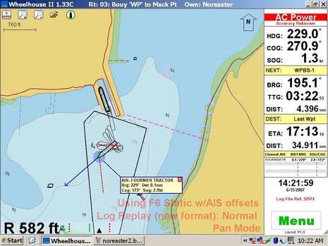
Above is a laptop screen from the Wheelhouse II program which is part of the Raven pilot package I discussed back in June when I got a ride on Penobscot Pilot. Skip Strong grabbed the screen from a recording of the Nor’easter outbound trip he piloted that day, and it’s well worth seeing at full resolution. As I wrote in my Sept. PMY column:
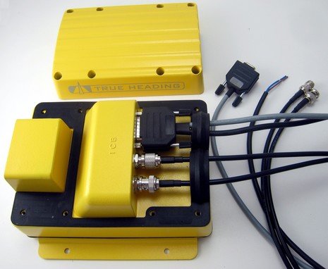
Back in June the FCC asked for comments regarding Class B AIS units, and several of you—along with the USCG and other safety minded organizations—all encouraged the FCC to approve, or at least waiver, transponders already approved and in use outside the U.S., as soon as possible. There were NO objections. I was not the only one who thought that units like this True Heading would be available shortly after the comment period ended, like now. But they’re not, and recently I heard that there will be yet another comment period and even waivers may not happen until October. How the FCC justifies it glacial pace I have no idea!
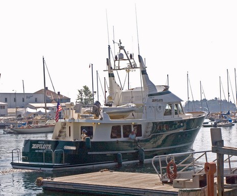
Darn, I was hoping to get a shot of Bruce Kessler in his wheelhouse departing the Camden Public Landing this morning, but got distracted by a contest idea (that you’ll find here this weekend). When I looked up, he and his all-ladies-of-a-certain-age crew were headed out into the haze. You may still be able to catch Spirit of Zopilote at Shine Micro’s Live AIS, which, as shown below, can now overlay on Google Earth (and shows Penobscot Bay thanks to the Penobscot Pilots). I really enjoyed meeting Bruce last summer, but my admiration is up a few notches further after a couple of coffee-sipping hours with him this morning.
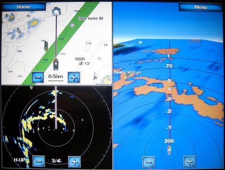
Not one of my better pictures, but the bigger version here will give you some sense of how the Garmin 4– and 5000 Series handle AIS targets. At upper left you can see the AIS target on a the regular 2D chart; my first impression is that the icon representation may in some situations be a bit too busy compared to a standard AIS triangle. But I do rather like the 3D target representation in the Mariner’s Eye 3D view (sorry it’s a bit indistinct; I’m going to have do videos of this stuff at some point). You can also see the target icon just showing on the radar screen (which also gives you a reference to how the 3D radar overlay looks in 2D).
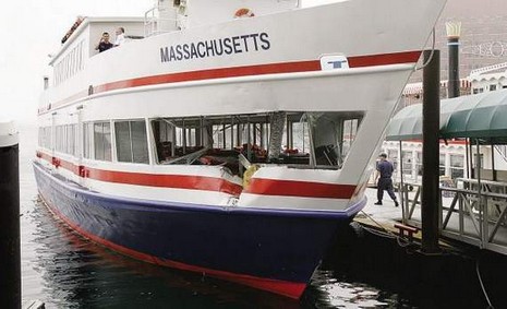
Interesting that an intrepid Boston Globe reporter figured out that AIS transponders might have prevented two Boston ferries from hitting each other in thick fog yesterday morning. This is the sort of thing that promotes public awareness of a valuable safety technology, and perhaps will encourage the FCC, USCG, etc. to move expeditiously on approving Class B and mandating its use on such vessels (or argue that Class A is worth the cost). On the other hand, operator error can not be ignored. Heck, these two boats both work for the MBTA. Wouldn’t you think that they’d know where each other was and be in VHF contact? Not that we all aren’t capable of mistakes. I’ve often thought that running ferries must be a particularly hard gig as the tendency to get lax must be major. (Thanks for the head’s up to Doran, who can, on a good day, float you over bustling Boston Harbor.)
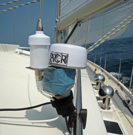
Apologies to ACR and Visions of Johanna! But here’s how I used duct tape and hose clamps, those old quickie install standbys—plus a new favorite, velcro tape—to marry the Nauticast B’s AIS tuned VHF antenna with its GPS antenna so I could secure both with a single rail mount. The antenna duo are not as compact or elegant as Y-tronic’s combo, but they seemed to work well. It’s also worth noting that while both come included in ACR’s $1,180 kit (still not approved for sale in the U.S.), you can use your own GPS source or your own VHF antenna (and you’ll find that the Nauticast B’s PL258 VHF connector is more the norm in the U.S. than the BNC type).
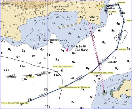
So somehow when I was actually plotting Spirit of Bermuda’s Class B AIS output in Hamilton Harbor my screen shots failed to save. But I still have the marks I made every time its plot updated and you can sort of see the jumping bean effect that results from Class B’s 30 second update rate. I connected them with route lines so you can get a better sense of scale, bigger here. As discussed earlier, a 30 knot boat is going to plot every .25 nautical miles; Spirit at 9 knots plotted at about .07 mile increments. It was a little disconcerting, especially when she made large course changes rounding up to a pier. (And, by the way, would have been twice as bad if I had been using a single-channel-at-a-time receiver). But, again, I still think Class B is valuable regardless, plus I figure some smart developer(s) is going to figure out a way to dead reckon these targets in a way that’s not confusing. Finally, small world department, Spirit was built only a few miles from Panbo HQ at Rockport Marine, and we watched her launch from the bridge of Shanghai Baby last August, as noted in an article just published in PMY.