
SailTimer, gone iPhone & handheld
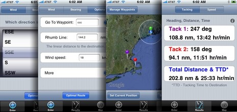
I first heard about SailTimer -- a set of algorithms for calculating sailing tacks, including total distance and tacking time to destination (TTD) -- back in 2006. And it did indeed become a very interesting feature of NavSim's SailCruiser. But developer Craig Summers was not done there. His Indepth Navigation company now offers a free, and very simplified, iPhone version of SailTimer as well as the $14 app illustrated above. Frankly, even the paid app doesn't seem as full featured as the online SailTimer demo yet -- you don't see what your calculated speed is, for instance -- but I know Summers is working on it. In fact, SailTimer 2.0, with tacking lines drawn between those pins on the map, is due out this week. And then there's the "Sailing GPS"...
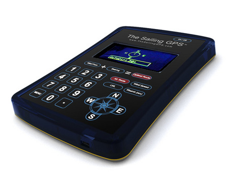
Yup, Summers has designed a handheld GPS with SailTimer math built in, as seen below. It's due to ship soon, and apparently I'll get to test one. In the meantime, the best way to understand the SailTimer app is via this YouTube video. And to really get into the problems surrounding traditional VMG numbers, you can read Dr. Summers article in GAM magazine, and also this Knol piece by John Navas. Whereas I've become something of a stink potter in my old age, I'm very curious what you blow boaters think of the SailTimer concept and implementations.
Seeing this, I just had to drop what I am doing this morning to take a look.
The GAM article is awefully long, looks like it could be summed up as
(1) most GPS units show the wrong ETA which gets progressively worse as you stay on the same tack to a destination more upwind then you can steer too. The reason is that they tend to use VMG to destination (not to be confused with VMG wind) which decreases as you stay on the same tack.
(2) most GPS's blank out the ETA (really, I don't experience this Raymarine and Garmin equipment)
(3) Conclusion: GPS products can't calculate a good ETA for a sailboat (agreed)
The Knol piece is cool, I need to re-read this at the start of next season. While we (sailors) all know that VMG wind (not vmg destination) has an optimum somewhat less than pinching but around close hauled and that changes based on wind velociy, figuring it out upwind is tough and downwind is near impossible without (drum roll please) a good measure of true wind speed (relative to water).
Maybe it's me, but I find more interest in the GPS calculators features (not convinced it works, just interested) around figuring this out for my boat and then using it in navigation, much more so then the promoted feature of getting an accurate ETA.
Putting this out as a cell phone app makes a lot of sense, now if we could just get information from my boat into the phone real time that would be sweet.
I would be curious how far summers takes the calculations, e.g. is it aware of current set/drift actual or predicted, takes into account the effects of land bending the wind, or the wind forecast for the day, etc. As the wind forecasts are really aweful, perhaps many of these variables are pointless to include unless the user can enter them and compare choices (if I continue on this next tack and the wind starts a circular shift sooner than forecast, will that hurt me ?). As good as this tack looks, am I toast after the current shifts later today?
When it comes to ETA, the current plays a really big role. I have been long awaiting the promissed ETA calculator feature in Coastal Explorer that will allow me to see how the ETA changes based on starting my leg sooner or later.