
CE & ACC, great but not enough! Part 1
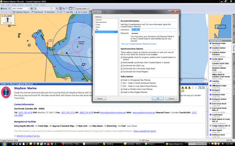
One thing I've always liked about Coastal Explorer is the way it handles points of interest (POI) information. It includes a vast, searchable gazetteer, along with coast pilot info that gets listed and icon-located when you're checking out a harbor ("places" tab). Plus it integrates Panoramio community photos if you want and Maptech marine facilities and port photos if you have them. (CE 2009 did not become Maptech Chart Navigator Pro 2009, unfortunately, though CNP, which is actually CE version 1, is still being sold as "new" software, also unfortunate.) You can see in the Options box above how Rose Point is working on an automatically synchronized Community Guide Book idea that has terrific potential. But, whoa, check out the new "Subscription" options that will appear in an CE update very soon. Rose Point has struck an interesting deal with the Atlantic Cruising Club guide folks, and thus CE users will get free partial ACC marina listings -- like the Wayfarer data above -- for those guide areas shown. They'll also get a neat way to integrate complete ACC guides into CE...
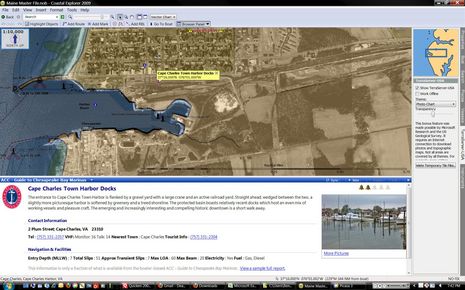 If you want more ACC marina information, you buy one of their printed guides for $25, and install the included CD, which contains even more data than the book, plus a stand-alone program for searching and viewing all that data if you don't have CE 2009. Below is page one of the typical marina data that will now show up in CE...
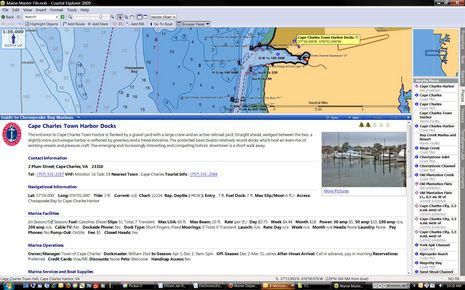 And here's more data on the Cape Charles Public Docks and general area. The ACC researchers really do their homework, and...
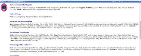 thus here's yet more data. Plus ACC's more subjective Notes and Notable. And there's more...
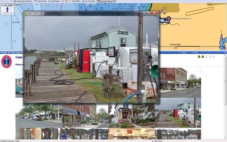
 If you click on the photo that starts a marina profile you get a gallery of photos that don't appear in the b&w printed guide. The particular shot I clicked on below perhaps illustrates the "interesting, textured experience" comment above and why ACC rated this marina only two out of five possible Bells?
At any rate, the CE/ACC integration is a smart move. Regular CE users get some extra data, and ACC gets a chance to show them thorough their work is. Cruisers who buy the book get another way to view the data, extra data even, plus an synching system so the data can be updated as needed. It's all good. But, as my "not enough" title suggests, I'm hoping Rose Point, and others, take POI presentation even further. Which I'll try to illustrate next week, in Part 2.
Ben,
Thanks for the write-up in regards to our new Atlantic Cruising Club collaboration. A few thoughts.
First, regarding Maptech Chart Navigator Pro, we evaluated our options after Maptech was broken up and sold; we decided that it did not make sense to continue the product, instead we chose to focus on Coastal Explorer. We offer a Chart Navigator Pro upgrade to Coastal Explorer for $99. Chart Navigator Pro users have continued support for 3D and all of the other Maptech data as well as the new features we�ve added over the last couple of years.
Even we are surprised to see Chart Navigator Pro currently offered for sale on various websites (including Maptech�s) since the product is no longer available, and has not been available for several months. We�ve heard there is a different version coming out called Chart Navigator Plus, which is actually a version of an older product called the CAP�n.
Regarding Atlantic Cruising Club. I�ve been trying to create a business relationship with an independent cruising guide publisher for fifteen years. Since it has never been done before there are no established business models to follow. Why has it taken so long? Well, various details of the business model have prevented this from happening before; Most publishers do not have their data in a format that can be easily converted for use on a PC, then there is the cost, who pays for the development and data conversion? With ACC we were able to overcome these problems. The ACC model is ideal, lots of free content and paid content available with the purchase of the book. I expect to see other guides to follow a similar model. Five years from now most PC applications and plotters will support this type of content. Now that the first publisher has a product, it�s a race to see who will be next.
One of the key benefits to the subscription model using the Coastal Explorer Network is that the data can be updated, whereas the printed material eventually becomes out of date. The other advantage is that users can make comments on locations or businesses and share those with other users. This feature will be available in the near future. We expect that for any given location there will be data available from all kinds of sources; Coast Pilot, Panaramio, guide books, and the public.
-Jeff