
Ft. Lauderdale Boat Show...tweet, tweet
Oct 29, 2009
This was an experiment in mini blogging the big show, but I intend to keep using Twitter to cover small events in marine electronics. Follow me!
Ben E | Permalink | Comments (5)
This was an experiment in mini blogging the big show, but I intend to keep using Twitter to cover small events in marine electronics. Follow me!

Visions of Johanna is now on the coast of Ecuador, the vast Pacific beckoning. As discussed recently, Gram Schweikert has set the sloop up to test and compare the new compact satellite voice/Internet systems from Iridium and KVH/Inmarsat. Above he's geek goofing with the KVH IP Phone and a Uniden waterproof portable which
can access four lines -- Skype, cell, Inmarsat FB150, and Iridium OpenPort. But he's sure been doing his homework. What follows is the longest Panbo entry ever, in which the good Gram details the hardware, the installation, the costs, first impressions of performance, and plans for future testing...
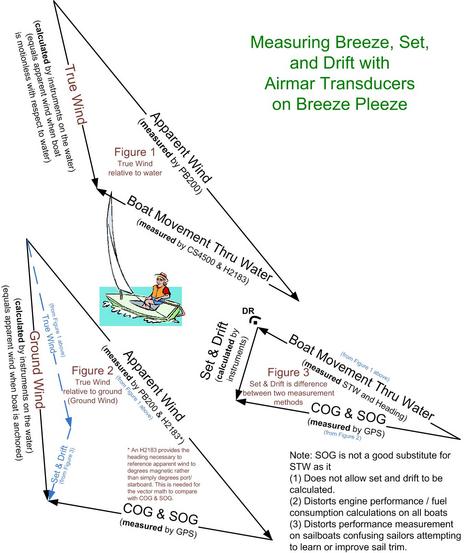 In Part I of this series, Dan Corcoran, and many commenters, got into not just the value of accurate boat speed, but the true meaning of True Wind. Click on on Dan's illustration above and check out Part II...
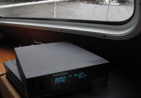
I finally got the Intellian D4 HD sat TV system I've been testing to misbehave. During Saturday's heavy rains -- when I was trying a lot of wet gizmos on Gizmo -- the D4 had trouble tracking one of the three DirecTV satellites it tries to switch among as you change channels. Whereas the system has previously worked fine with the boat laying at my float, despite the less-than-optimal antenna location, I'm guessing that the problem was signal interference from the water in the atmosphere. Further proof: It only had trouble with 103 (aka Spaceway 1) which not only uses the harder-to-get KA frequency but also has the most distant geosynchronous orbit (at 103W longitude), and hence sits at the lowest elevation with the most atmosphere between it and Camden, Maine. I still had a lot of channels available, though, and aside from the downpour the D4 has been pretty much flawless...
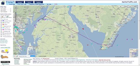
I am a wee bit jealous. That's my brother-in-law Richard Itkin driving his Grand Banks 42 Brilliant down Chesapeake Bay this morning, having left New York Harbor yesterday morning (and Barrington, RI, on Tuesday). As a guy who drove submarines and sub tenders for the U.S. Navy, Rich has a well developed appreciation for collision avoidance, and he's been tickled with the ACR Nauticast B AIS transponder he installed a few weeks ago. But before I pass on his reports, please click on the screen above and note something I just realized regarding MarineTraffic.com.
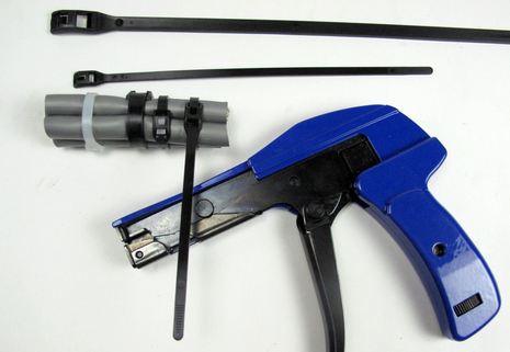
Does too much fantasizing about the electronics future make you too want to jump back to the practical? Well, how about cable ties! I've used several hundred of them in the last six months, and cut a hundred more, and have some opinions. For one thing, I'm grateful to the Cobra cable tie company for sending me samples of their unique low profile design, because it works great. The material and ratchet mechanism are strong, they look tidier than regular ties, and -- most important, I think -- you, or someone working on your boat at a later date, will not cut their hand on a sharp plastic snag. You can tighten and trim Cobra ties OK with a wire cutter, but that Eclipse tool works slick (and slightly better than the Ancor version I already had, in my opinion). Cobra ties cost a bit more and don't seem widely distributed, but the company sells direct (though penny pinchers may want to go elsewhere for the tighten/trim tool).
I also like hook and loop ties...
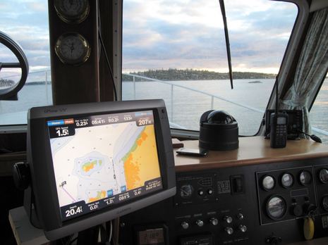
I'm working on a January Yachting feature about trends in marine electronics, and I'd appreciate your feedback. One thing I'm fairly sure of is that multifunction displays have come a long way in recent years, and justifiably dominate the mid size boat market. I took a solo overnight expedition last week, and had to note again that each of the four MFD/radar systems currently installed on Gizmo is pretty darn powerful. Especially if you imagine yourself five to ten years back in marine electronics. Note how the Garmin 24HD radome is imaging and overlaying that low ledge seen off to starboard, without any tuning, and also the NMEA 2000 data flowing onto the 5212 screen (and every other display aboard). Note, too, the iPhone on the dash -- right then running SailTrac, a trip tracking and blogging program I'll write about soon -- and the Standard Horizon HX850S, which also has a GPS and is ready to call in the cavalry via DSC should I screw up. There are many trends to consider...
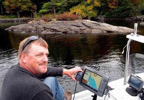
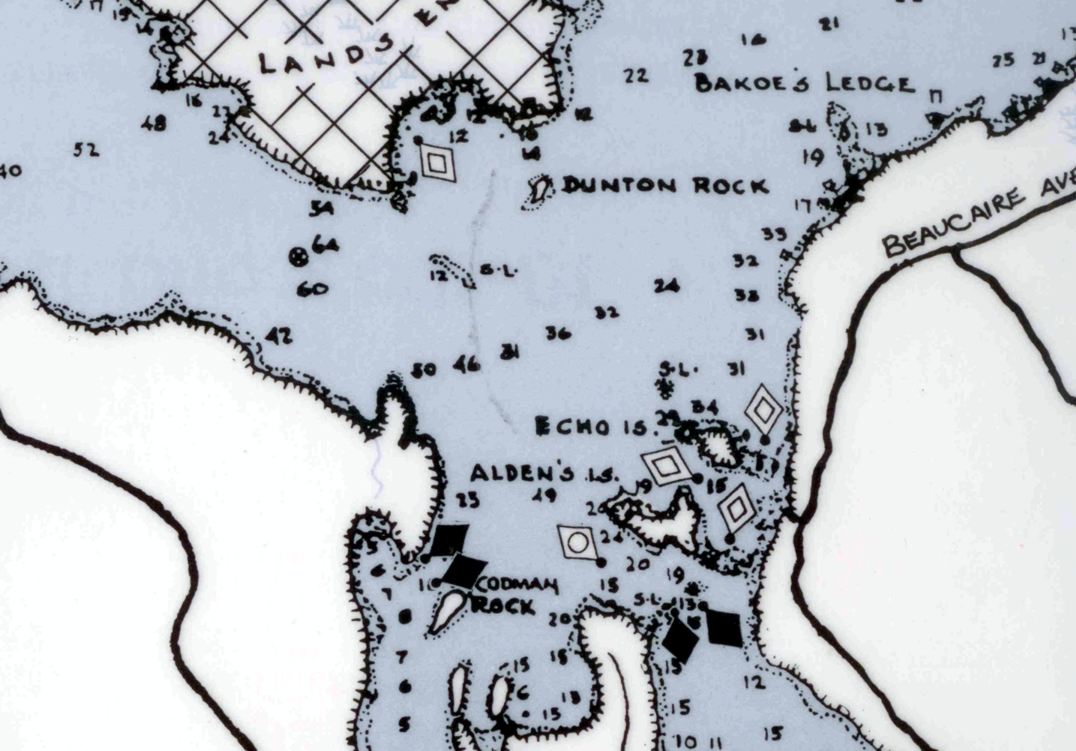
Tim Thurston earned that grin. We were out on Lake Megunticook randomly comparing the digital map I helped Navionics make last fall with the survey work Tim did for his little Maine Lake Charts company at about the same time. And while that little islet in the background is on the beautiful MLC paper map Tim made, and on that Garmin Etrex he managed to put his digital data on, it was completely missing from the Navionics map! While this is a shallow and somewhat out-of-the-way spot I steered us to -- and both maps are way, way better than what was available until to this summer -- I tend to think that Tim got the details better. Unfortunately boaters can't make best use of those details just yet...
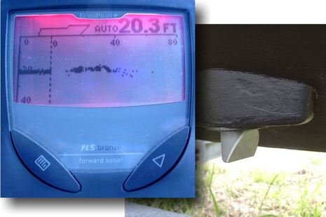
Even though the EchoPilot Foward Looking Sonar (FLS) I tried back in 2002 couldn't see very far and wasn't reliable (kelp seemed able to hide even steep Maine ledges), it hooked me on the potential of the technology. In tricky waters my eye regularly flicked to that little screen above, hoping to see the bottom ahead. Thus I got excited when Furuno previewed a purportedly powerful FLS in 2005, and again when hints arose last winter. But that product has never surfaced. Forward scanning obsessed Interphase, however, is attacking FLS issues from two directions...
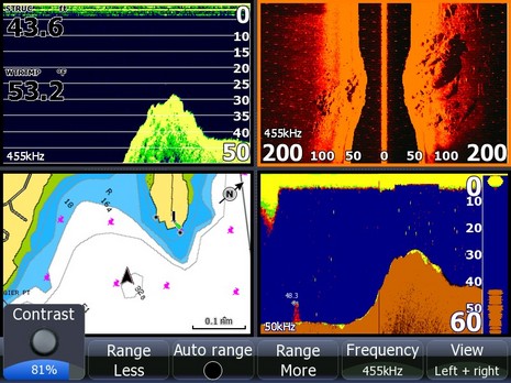
On Monday I spent a few hours cruising around the Harbor and Bay with Lowrance's StructureScan module attached to an HDS-10. Impressive! This upstart seemed to image the bottom as well as the Humminbird 1197C I was also running, and Humminbird has completely owned this niche for years. Lowrance's side imaging also seems easier to use. Humminbird SI, for instance, doesn't have an auto range feature that adjusts the displayed bottom width (and resolution) according to the depth, nor does it have the useful soft keys seen above. They both work pretty well, though, and the more I use them, the more I think they're valuable to fisherman and even cruisers...