
Garmin at FLIBS, 640 & GWS 10
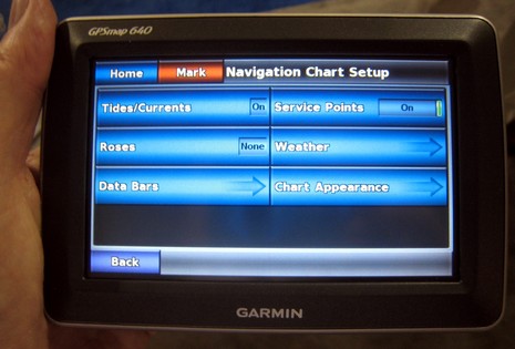
Garmin had a working GPSMap 640 at FLIBS, and I found a couple of nice surprises on it. One is that it does AIS plotting, which wasn’t even mentioned on the press release. More important really is the improved touch screen interface. Notice the status labels on the big buttons above; in cases where the only choice is on/off, like Tide/Currents, just tapping the button changes the status. Which beats the hell out of the norm on most Garmin marine units, i.e. tap (or soft key, or Enter) for another screen, choose between on or off, go back to original screen. On the 640, it’s one tap instead of three (or four, if you don’t have touch or soft keys).
Then are variations like Service Points; the slider is a simple on/off while the pressing the main button gets you to details. This all may sound trivial but I once joked that one day we’d know the owners of (non touch) Garmins by their weirdly over-exercised thumbs. There are lots of ways touch buttons and soft keys can be made more efficient and informative (as suggested on the HDS screen), and I was glad to hear that this and other 640 interface improvements will eventually make their way into Garmin’s larger marine units.
Speaking of touch screens, did you notice last night how gleeful the CNN election announcers were with their giant multi-touch map screens? Given that, and iWhatever, and Garmin’s 640/5000 efforts, and Planar’s bright screens, won’t we be seeing a lot more touchy marine products?
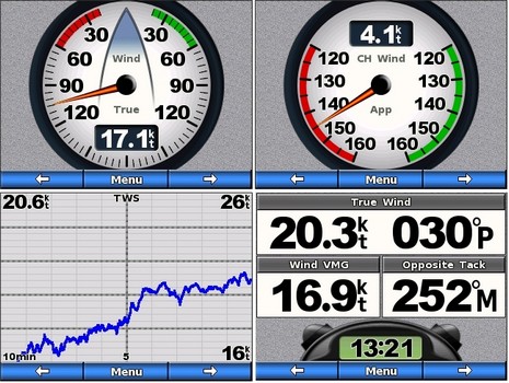
Now, about Garmin’s GWS 10 wind sensor: I’d seen a beta of wind-related GMI 10 screens at the NMEA conference and at FLIBS I was handed the neato screen shots below. As I understand it the full wind rose at upper left can be set to automatically switch to the downwind gauge upper right, or a close hauled gauge, when you go to that point of sail. Obviously strip charts are available, as well as that timer seen lower right. And I’m told that the GMI update that includes these wind screens also fixes the page limit and customization issues I bitched about when the GMI first shipped.
Garmin also kindly researched the question of screen brightness versus power consumption, of some concern to sailors attracted to Garmin’s new wind possibilities. Here’s what they told me: With a boat’s battery at exactly 12.0 volts, a GMI 10 at 100% brightness consumes 226mA (or 2.7W), 50% brightness = 123mA (1.5W), and 0% brightness = 93mA (1.1W). And “the current can be calculated for any input voltage by dividing the power (wattage) rating by the voltage. What do you watt-watching sailors think of that?
I think that the user interface on MFDs is a byzantine. For example I am still relearning to use the Raymarine C80 each spring as finding commands is usually buried deep inside of of a layers of menus and required drilling down to find what I want. My biggest beef is getting the thing to display what I want and and the scale I want. One has to use a toggling soft key to move from "cursor to ship's location" and if you scroll (ICK) you often have to redo it because the toggle is on the wrong choice.
When working with paper charts your eye moves to where you want it and your brain focuses on the area of interest. Doing this on a the plotters I have Horizon and Raymarine make me feel like I am programming the movements of my eye.
On the other hand the IQue interface offers a second type of panning and zooming in addition to the "fixed" scales achieved by button pressing. That is to draw a "marquee" of the area of interest with the stylus. The screen is then instantly redrawn centered and fit to the marquee. Panning is the same. One doesn't have to increment orthogonally.. you just push the stylus in the direct where you want to see.
I won't go into finding other commands on the C80 and the multiple steps one needs to get there. Of course this is a consequence of stuffing oodles of commands into a few switches or buttons. I don't know the solution here, but the GUI sucks on the Ray and the Garmin.
I find I use the simpler hand held device more that the fixed mount for multiple reasons.
How about a blue tooth feature for the hand held to receive and show radar overlays from a master unit! YUMMY.