Doh! Earlier this week I wrote a PMY May column on marine satellite broadband, but despite lots of research only this morning learned that Iridium is also piling into this relatively small, if high dollar, niche…and with what looks like a really interesting new technology. The omni-directional antenna inside that 9" by 21" dome above has no moving parts, and yet can supposedly provide three phone lines and “up to” 128 Kbps of mobile Internet connectivity anywhere on the globe. Thats not nearly as fast as what VSAT and Mini-VSAT can do, but it’s darn close to Fleet Broadband 250 abilities, and may be plenty good enough for many offshore yachts and commercial boats. In fact, if Inmarsat’s IsatPhone looks like a competitive lunge at Iridium, this sure looks like the “touché”! The OpenPort press release doesn’t mince words:
Well, I’ll be darned. As Damon pointed out in the screenshot entry, the Northstar M Series also has the feature. It’s not hidden either; I plugged in the lab’s test M121, and the command is right there on the System menu (ahem), and self explanatory. I did hit a snag creating a “User Card”, though; it took a call to Northstar support to find out that it can’t exceed 512 Megs and, sigh, those cost as much as bigger cards these days. At any rate, one is on its way, and soon I’ll put the unit through a Kagstrom AIS simulation.
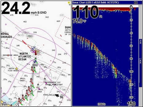
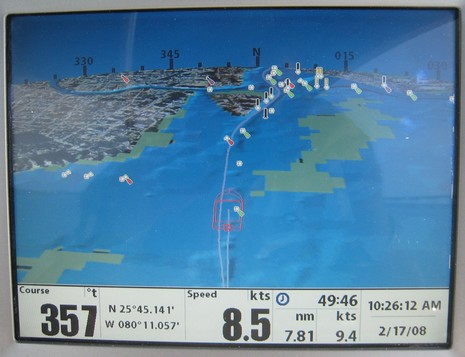
Now that you know how I got the screenshots, here are examples of Lowrance’s new networkable Broadband Sonar as seen on the HD (hard drive) version of a GlobalMap 9200C. (The 9300c HD, oddly, doesn’t seem to be listed as a current product?) The full 800x600 screen above gives you some sense of the scene as we exited Miami looking for deep water and fish. (Yes, the Lowrance radar was running, but possibly wasn’t tuned, and certainly looked a lot better in the harbor at slower speeds.) What you can’t see is the dinky transducer (this one, I think) that was hung on the stern of the 330 World Cat demo boat (with, yeeha, twin 300 hp Suzukis). Remember that the LBS premise is amazing performance with only 250W of peak-to-peak power, “a whisper instead of a shout” as Navico likes to say.
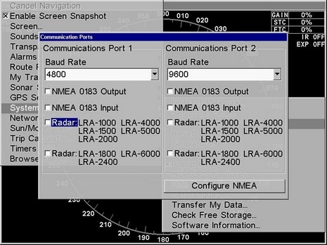
Whereas I got the week started on what’s largely a trade subject, let me add an unsolicited suggestion to everyone who makes plotters, multifunction displays, or any other marine electronics with a dedicated screen and some sort of accessible memory. If possible, please add a screenshot feature! My intent is obviously selfish; dumping .jpg or .bmp files to a CF or SD card is so much easier than photographing displays, and the results so much better for web and magazine readers.
It’s ironic that I wrote about a neat Maptech price/packaging move Friday afternoon, as I now know that simultaneously the employees were learning that the company would be sold, either whole or in parts, and that it would immediately go into a sort of maintenance mode, which included a few layoffs. Naturally the relatively tiny marine electronics industry has been a-buzz about this ever since, and naturally a lot of conjecture, if not pure BS, has already accrued. Here’s what I know:
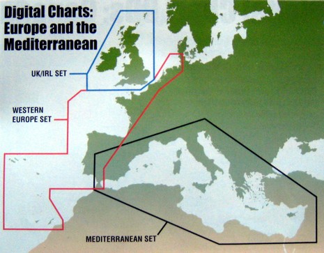
One of my happiest discoveries at MIBS was not a new product or feature, but simply a matter of pricing and packaging. Maptech has radically reduced the hassle and cost of owning its international raster charts, really big time.
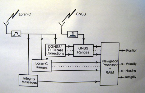
Remember all the hand wringing about shutting down the Loran system? Well, the inimitable Langhorne Bond was right again; the USCG’s threat was in fact just smart politics. President Bush’s 2009 budget “migrates” Loran responsibility from the Coast Guard to another Dept. of Homeland Security (DHS) unit called the National Protection and Programs Directorate (NPPD). The budget further states that NPPD will be responsible for finishing the transformation of Loran-C to Enhanced Loran (eLoran). On Feb. 7, DHS announced eLoran will not only back up marine and aviation GPS navigation, but enhance navigation for “first responders” and others operating in difficult GPS environments. This is a big deal.
A great tip from Panbo reader Russell D.: The Space Science and Engineering Center (SSEC) at the University of Wisconsin offers a freePAW (PDA Animated Weather) service that looks like it would work well on Web enabled PDAs and Smartphones (also as a Google Gadget). That animation above is the New England Regional 15 Minute image and it even shows something called NSSL Forecast Radar, i.e. a computer guesstimate of where the precip will be in an hour (I grabbed the image at about 11pm). I’ve heard of this technology, but this is the first time I’ve seen it. PAW covers most of the U.S., often in metro detail, and a scattering of foreign locations. The data for any given place varies, often in interesting ways (research center!). Like check out New Zealand with jet stream and radar. Unfortunately I’m only peeping at this on the Web. You readers able to try PAW with something mobile…please report back. Thanks Russell! Oh, and if this pushes your button, also check out Memory Map’s Weather Radar, which may well be a more consistent, and data efficient, resource.
Some day I’ll figure out how to use the “tag” function built into this blogging software, and this entry will be one of several easily found by clicking “Smart Interface Ideas”. I’ve never seen a compass rose overlaid on a 3D plotter horizon like this, but it struck me as totally intuitive, very useful, and without a downside. Check out the big image and imagine yourself driving up Biscayne Bay toward the Miami River and the MIBS madness beyond. Notice how 3D gives you buoy and bottom detail near your position plus a good, if less detailed, sense of what’s ahead. (In this particular case the bottom contours aren’t very emphatic, but if you look at the 2D raster of the same area, you’ll see there isn’t much depth differentiation around here, and there was probably a tweak we could have done to emphasize it. It’s also evident that the wire frame boat icon is a bit large, putting the green lit mark in the galley!)
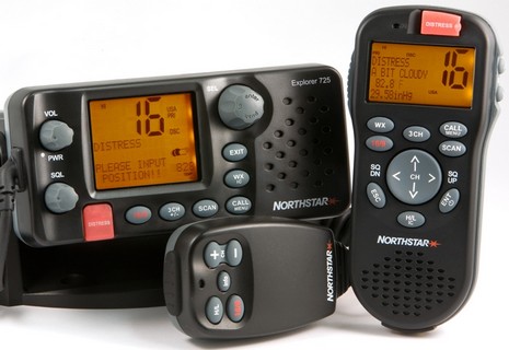
This Northstar Explorer 725 VHF, along with its optional wireless handset, was one of the few entirely new electronics introductions seen at MIBS (at least if you’re a regular Panbo reader ;-). And compliments to Northstar for using real screens in these product shots, instead of pasting in dummies as is often the case. It is a bit humorous, though, that while the photographer did manage to power up the units, he clearly did not attach a GPS, which is why the fixed unit is plaintively displaying “PLEASE INPUT POSITION!” so that it can do its DSC duties properly.