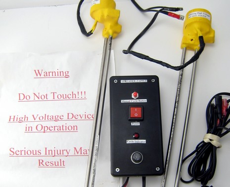
I’ve had a rotten day, and maybe you too could use a laugh (aside from the must-see “big ass table” video JT brought to comments). The other day I found the prototype above under a few years of dust in a remote nook of the lab, never tested or returned. Its goal is to disuade birds from perching on your spreaders and leaving a mess, and to do so it converts small quantities of 12v DC into 8,000–15,000 volt DC 600 HZ current. Don’t ask me how, but I was told that the resulting zaps are very effective at avian behaviour modification! However, though the developer has had a string of hit products since, this one never came to market. I’m guessing for the same reasons I somehow never got around to plugging it in, a behaviour I’m rarely guilty of. (I am often slow returning things, but this is a record.)
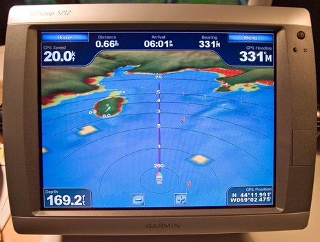
Um, speaking of 3D (and one very funny man), I just unpacked and powered up a 5212 and…wow! On first impression I’d say its touch screen control is as smooth and responsive as Maptech’s latest i3 (and that’s saying something). And weren’t there some nice surprises during my first hour. I’m not sure I’m ready to navigate without spot soundings, but Garmin’s Mariner’s Eye 3D (g2 Vision card required) is darn close. Note, bigger picture here, how you can specify hot colors for the hazardous areas. (The ledges at about .4 miles, two o’clock, should show hotter, but maybe that’s just a local glitch. Will check.) Note too the yellow botches of radar overlay; they’re just a simulation here but I’d sure like to see how they work in reality. (I was monitoring VHF as I tested this unit in the lab. Maine’s blanketed in a dungeon fog this evening, but AIS shows the Cat still doing almost 40 knots offshore; it’s hairy out there!). But what really surprised me is that the two lit navigation aids to Camden were graphically showing their characteristics in this 3D mode (see the green dot over Curtis Island to port). I didn’t even know Garmin had “borrowed” that C-Map Max feature. Now all this may apply to Mariner’s 3D on every new Garmin unit, but the screen below certainly doesn’t. Note the very large touch keys, and note how they’re grayed out when they don’t apply to a particular data field. So easy to use; so sexy time!
Continuing on about how we’ve just gotten started with electronic cartography, check out the demo video at Perceptive Pixel showing the developers exercising two handed control over Google Earth and other imagery. Then there’s Microsoft’s new “Surface Computing”—also “multi touch”—nicely presented by Popular Mechanics on this video. It sure seems possible that the ‘surface’ could be one wizbang chart table…eventually. Meanwhile, Google has introduced Maplets, which means that users can now contribute mini applications as well as content. And Michael “heywhatsthat” Kosowsky has already created three, two of which I used in the mashup below (and bigger here). One very usefully overlays Michael’s topo lines and the other guesstimates new shorelines if sea level rises. Just add 150 feet and I’ve got waterfront!
PS 7/18: “…a quantum leap from our 2d/3d apps like Google Earth”? Check out this video about Seadragon and Photosynth (thanks, John!).
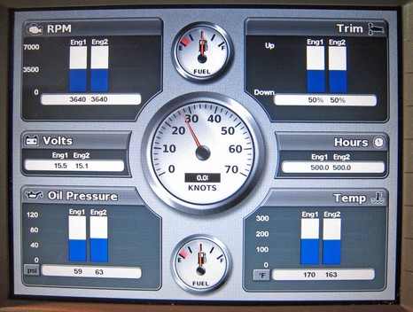
I had a long phone interview with Garmin this morning and was mucho pleased to learn that the limited NMEA 2000 support in the 4 and 5000 series is only temporary. Garmin’s Marine Sales Manager Greg DeVries explained that the reason they took the approach they did—i.e. N2K engines only, as seen in the (simulated) screen above and its alternate—is that they’d “still be in development” if they hadn’t. He promised that “Going forward, we're absolutely going to embrace full NMEA 2000. It will just be a software upgrade for existing customers.” That makes what I first heard sit a whole lot better!
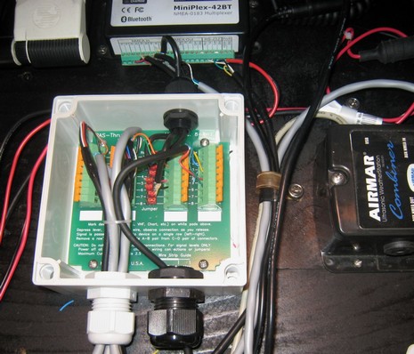
I first heard about it at NavaGear, immediately contacted developer Paul Shirley about a sample, and now am an extremely pleased PAS-Thru Box user. You may already have read my whining about NMEA 0183 wiring difficulties. Many boats these days are spider-webbed with fine gauge wires carrying important data; they’re painful to install and often end up way too vulnerable to damage, not to mention poorly documented and hard to modify. Well, I don’t know how the Box could do more to remedy these problems. Those orange spring tabs above (bigger photo here) are powerful and purportedly gas tight.
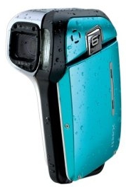
In today’s New York Times, the inexhaustible David Pogue reviews three waterproof digital cameras—the Olympus Stylus 770 SW, the Pentax Optio W30, and this Sanyo Xacti E1. Now the first two are not exactly brand new. In fact, I tested the Olympus over a year ago. Then I actually purchased the Pentax last November. Contrary to Pogue’s conclusions, I liked the Pentax much better, mainly because I think it takes much sharper pictures. Still, I ended up gifting it to my daughter and buying a Canon PowerShot SD800 IS (as foreshadowed in that entry). This little camera I adore, and you’ve seen the results in many recent Panbo entries. It takes amazingly good video too. But its not waterproof, and now, damn it, Pogue reports that the truly new Sanyo Xacti, which is primarily designed as a video camera (spec page here), takes better stills than both the Olympus and the Pentax! By the way, aside from the wonderous Woot, I pretty much satisfy my gadget habit at Amazon these days. It’s hard to find a better combination of ease, service, and price. Plus Panbo is an “Associate”. Which means that if you need one of these cameras, and of course you do, please generate a commission for Panbo by using the link below to buy it. Thanks!
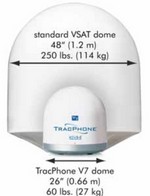
Game change! This morning KVH announced the TracPhone V7, a marine VSAT system capable of delivering truly broadband Internet, including telephone (VOIP), to big-budget yachts cruising much of the Americas and Europe (including transatlantic, see below). But you don’t need a mega-size platform for the V7’s dome, which is an astounding 85% smaller than what it currently takes to get this level of service (and 65% smaller than slower Inmarsat Fleet 77 domes). Hence the “mini-VSAT Broadband” name for the associated satellite service, whose costs are also said to be radically smaller than existing offerings. For instance, the per megabyte price at 512Kbps-up/1024–down is $5 versus $32 for Inmarsat’s 128/128 F77 service, and there are various bundles and monthly plans that bring it down further.
Pardon a slightly meta sidetrack, but two bits of the massive media flow got my attention. One is a Wired article about Google Earth which makes the case that the future of cartography is user data. “We're all mapmakers now, which means geography has entered the complex free-for-all of the information age, where ever-more-sophisticated technology is better able to reflect the world's rich, chaotic complexity.” Then there’s the news that scientists have calculated that the diameter of the globe is about 5 millimeters less than thought. Not even a quarter of an inch! Among other techniques, they used atomic clocks, quasars, and 70 radio telescopes to establish base lines, and they say that the precision they are after will help to better measure phenomenon like global warming, ocean currents, and tides. As amazed as most of are by all the information now available on a yacht’s bridge, I think we’ve just gotten started. (For some really interesting dope about related planet dimensions, and early cartography, check the beginning chapters of Nigel Calder’s How to read a nautical chart, which also has practical uses!)
PS 7/12: It turns out that Captain Richard Rodriguez, who has a thing or two to say about the Boston ferry collision (see his fine blog), has also used Google Maps to mark the most frequently hit rocks in the San Juan Islands. What I’m talking about!
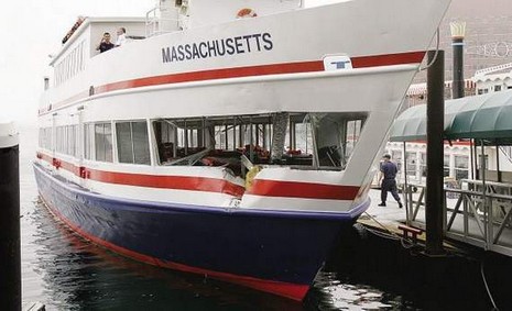
Interesting that an intrepid Boston Globe reporter figured out that AIS transponders might have prevented two Boston ferries from hitting each other in thick fog yesterday morning. This is the sort of thing that promotes public awareness of a valuable safety technology, and perhaps will encourage the FCC, USCG, etc. to move expeditiously on approving Class B and mandating its use on such vessels (or argue that Class A is worth the cost). On the other hand, operator error can not be ignored. Heck, these two boats both work for the MBTA. Wouldn’t you think that they’d know where each other was and be in VHF contact? Not that we all aren’t capable of mistakes. I’ve often thought that running ferries must be a particularly hard gig as the tendency to get lax must be major. (Thanks for the head’s up to Doran, who can, on a good day, float you over bustling Boston Harbor.)
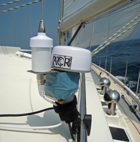
Apologies to ACR and Visions of Johanna! But here’s how I used duct tape and hose clamps, those old quickie install standbys—plus a new favorite, velcro tape—to marry the Nauticast B’s AIS tuned VHF antenna with its GPS antenna so I could secure both with a single rail mount. The antenna duo are not as compact or elegant as Y-tronic’s combo, but they seemed to work well. It’s also worth noting that while both come included in ACR’s $1,180 kit (still not approved for sale in the U.S.), you can use your own GPS source or your own VHF antenna (and you’ll find that the Nauticast B’s PL258 VHF connector is more the norm in the U.S. than the BNC type).


 In today’s New York Times, the inexhaustible David Pogue
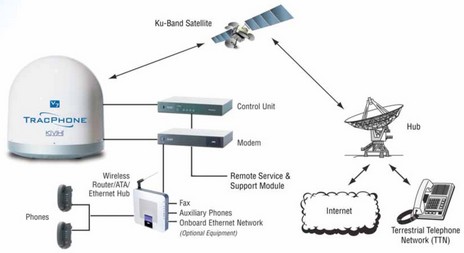
 to big-budget yachts cruising much of the Americas and Europe (including transatlantic, see below). But you don’t need a mega-size platform for the V7’s dome, which is an astounding 85% smaller than what it currently takes to get this level of service (and 65% smaller than slower Inmarsat Fleet 77 domes). Hence the “mini-VSAT Broadband” name for the associated satellite service, whose costs are also said to be radically smaller than existing offerings. For instance, the per megabyte price at 512Kbps-up/1024–down is $5 versus $32 for Inmarsat’s 128/128 F77 service, and there are various bundles and monthly plans that bring it down further.