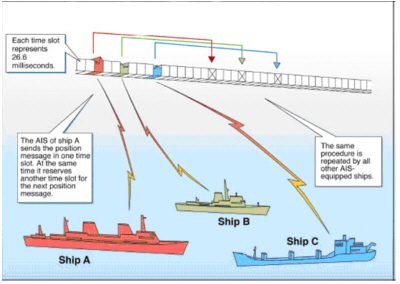
Geez, this morning I found myself confused about Class B AIS details touched on yesterday, and realized that my sources are somewhat sketchy. The USCG AIS site is pretty informative generally, but its Class B particulars seem suspect, the statement “IEC has begun work on a Class B certification standard, which should be completed by 2003” suggesting that it has not been updated in a long time. I am grateful for the Documentation section of AISParser.com, which is where I found the following message info, much edited and with a few notes added:
Message 18 - Standard Class B CS Position Report: UserID/MMSI, Time, SOG, COG, Longitude, Latitude, True Heading. {CS, or Carrier Sense, integrates “politely” with the Class A protocol known as Self-Organizing Time Division Multiple Access or SOTDMA, illustrated above}. Message 19 - Extended Class B Equipment Position Report: Same as 18, plus Ship Type and Dimensions {measured bow/stern and port/starboard relative to GPS, which may be why they are often screwed up}. Message 24 - Class B CS Static Data Report: UserID/MMSI, Boat Name, Ship Type, Call Sign, Dimensions, and Vendor ID {i.e. transponder manufacturer, to help track down problems}.
While I don’t understand the purpose of #19, which seems redundant, I think that the list includes every significant data field that a Class B can transmit. But I could be wrong!
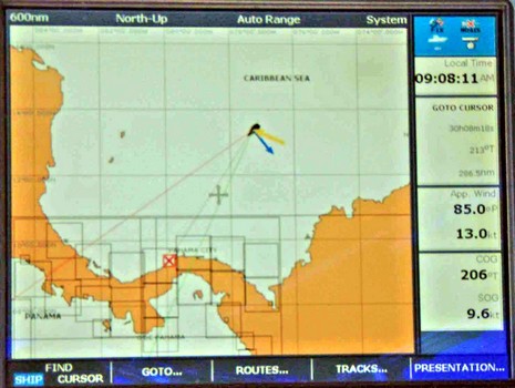
A wildly coincidental e-mail is going around. While John was using his Raymarine E-Series to track AIS traffic in the Channel yesterday, Mike Harker was grooving on what his E and autopilot could do as he power reached (9.6k) toward Colon, Panama. Last night he somehow blast emailed the photo along with some enthusiastic text, including a good explanation of those five lines around his boat plot:
1) the thin red line (left) is the course the boat is steering to keep the boat headed in the direction of #2. {aka Heading} 2) the thin black line (middle) is the direct course to the destination {the Colon waypoint}, or as sailors call it the “Rhumb Line”.
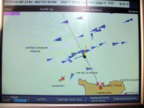
Ever wonder why the U.K. and Western Europe are such AIS hot beds? John C. send in this shot of his zoomed out screen, taken as he sailed across the English Channel yesterday:
I was heading northwest just about right angles to the main shipping routes. Those going northeast are heading up Channel to Hamburg, Rotterdam, Antwerp, Kiel Canal etc, and those heading SW in the other lane are heading to the rest of the world. A couple of cross channel ferries are more north/south. Equipment is a Raymarine E-80 with additional VGA screen (in photo) and Easy AIS receiver.
I wonder what this picture will look like with class B's as well! I am planning to upgrade to class B soon - please lets get some real user experience on this subject on your site soon! {I hope so too, but we don’t even have B over here yet—ed} BTW: with the class B's, do you know how I might differentiate between Underway Sailing, and Underway Motoring? {Anyone?}
PS I’d bet that if the 47’ Wahkuna, making a similar crossing in 2003, had had an AIS receiver like John’s, it might still be afloat. I wrote about the accident here, and the amazingly complete MAIB report is here.
PPS Regarding Underway status (and thanks to Marinate’s input below), apparently Class B can not send out Nav Status, but will see the Nav Status of Class A transponders.
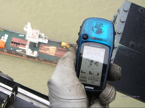
Garmin is making waves beyond its smart seeming autopilot acquisition today. For one thing, a bit of evidence in the incident involving the 15 British Royal Navy detained by Iran is the clever helicopter photo above, in which a wee little Garmin eTrex is being used to prove the ship was in international waters. Garmin was also selected as a new member of Wired magazine’s 40 most innovative companies, at 22 just above Amazon’s current rating, yet. But maybe the most interesting tell is a call I got today from a hedge fund researcher working on the investment premise that Garmin is such a juggernaut that publicly traded competitors like TomTom and Raymarine may be good shorts. I don’t know much, but I don’t think I’d bet on that.
Moments ago Garmin announced that it has acquired Nautamatic Marine Systems, the inventors and manufacturers of what’s arguably the most innovative autopilot system out there. When I first profiled the TR-1 Gladiator in a 2004 PMY column I noted that breaking into this niche has to be really hard as experimentation and testing are difficult and reputations are built over decades. Hell, I think even the Furuno NavPilot has gone slowly, despite the great name and what I understand is very good performance. At any rate, Nautamatic stuck with it, eventually began to prove its technology, and—yeehaa!—just made the big leagues. Naturally a Gladiator autopilot is going to be a lot more attractive as part of Garmin’s already ambitious Marine Network, both to individuals and boatbuilders, and I wouldn’t be surprised if Garmin engineers help Nautamatic shine up its user interface a bit (though the “Shadow Drive” feature needs none). Of course, the bigger picture here is that Garmin—obviously intent on going toe to toe with Raymarine, Navico, Furuno, etc. over serious recreational boat electronics—just stepped a dite closer, ramping up a competition that I think is good for all of us. It’s also ironic that today I’m finishing up my PMY feature on ideal electronics systems! At least I recommended designing such a system so that it is easily modified or even replaced.
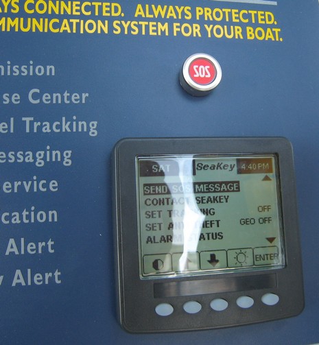
I had a hard time getting enthused about the original SeaKey (explained here, with humor, by good ole Bill Pike), because its communications link seemed pretty flaky. SeaKey v2 is a major upgrade from v1, adding an LCD interface and two-way satellite communications, but the goal remains the same…an OnStar-like service for boaters. There’s a call center able to both handle emergencies and deliver concierge service. Plus you get geo-fence security and simple monitoring—bilge, battery, and main power switch—when you're ashore. You can even send e-mails (though short, and hard to key in), and subscribers get a personal Web site where friends and family can they follow their cruises. Stolen boats have been recovered using SeaKey, as documented in this PDF, which contains the wonderful:
Miami-Dade Police officer Neubauer stated while talking to the SeaKey Response Center Coordinator, "[Darn], this thing works good!"
But I’m not sure that SeaKey has really caught on, or even if it has any direct competitors. Opinions, or references, anyone?
Well, Inmarsat’s 2004 projections on the size and timing of marine BGAN may have been a bit optimistic, but the fourth generation birds are in place and the service appears to getting more and more mobile, like this ruggedized Hughes 9201 (thanks, Russ!). “The unit supports speeds of up to 464/464 Kbps transmit/receive, has a built-in WiFi access point/router, and supports dedicated IP QoS at up to 128 Kbps. It is also software upgradeable to the high-performance Class 11 land vehicular rating, which will operate with Inmarsat's BGAN-X network expected to be commercially launched later in 2007.” I don’t yet know what BGAN-X is, but I’ve heard that this nearly global broadband service will eventually come to boats in Fleet 33 size antenna domes. Meanwhile Steve Dashew has sniffed out BGAN pricing, which seems pretty good, and is apparently experimenting with his own funky marine version using a FollowMeTV tracker (a neat product I’ve been meaning to Panbo about for some time). As I’ve said before, the Dashew family’s SetSail.com is a great resource.
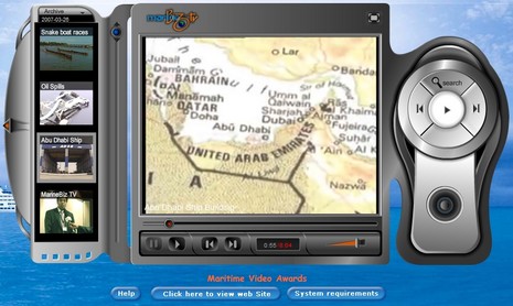
I know I’m beyond the W.Weirdness window, but maybe you need a Monday distraction? Check out brand new MarineBiz online TV. There are lots of curious clips available but search on “Operation Training” and skip right to Part 4 for some work that would make Monty Pyth*n proud. Seriously, though, MarineBizTV is based in Dubai, and Dubai has become a marine industry buzz word. Why? Well, this country is building so much waterfront residential properties, like The Palm Jumeirah, that I’m told it will eventually exceed Florida’s by 50%, and new yachts, selling well already, are expected to number 100,000 in the next 10 years. Marine electronics opportunities…you betcha.
PS. Given that “The Vision of MarineBiz TV is to become the single point of contact and reference for all marine activities and information worldwide,” should I be worried?
PPS. Truly weird: I had a hell of time posting this silly entry, because it turns out that the correct spelling of Monty Pyth*n causes a .cgi error in this blogging software setup, a little joke by some programmer somewhere I guess!
Magellan has not been doing much in the North American marine market recently, and actually this new CrossoverGPS comes loaded with street maps and topos, but you need to purchase pretty pricey chart SD cards to use it on a boat. Nonetheless that little 3.5” touch screen appears to be quite able (don’t miss the demo). I’d like to test it versus the Lowrance iWay 600c, supposedly heading my way for delivery next week. Have a fine weekend!
I’m hesitant about using Panbo as a bug list, but, geez, I’ve been getting bombed with bug reports. So, here goes:
It seems that some or all Icom 802s, almost undoubtedly the premier SSB marine radios, have a clipping problem as noted here at Lectronic Latitude, and here at Icom itself.
A reader reports that his Raymarine E-Series Sirius Weather system messes up some NOAA buoy reports, specifically showing oddly high wind speeds. I don’t have a link to this but have seen correspondence with Raymarine which admits that it is their problem, not Sirius’s, and promises “to address it in a future E-Series software release” (which is less aggressive that the reader would like).
Another reader reports another weirdo: apparently some older Garmins stop sending valid NMEA messages at 23:59:59 GMT. Pascal and others are on the case at rec.boats.electronics. I also got some graphics from a Panbot which showed how a certain BlueChart v8 Bahamas chart was out of whack, putting the routes he’d carefully collected on a Blue Chart v6 into foul waters. They are worth an entry one day to reinforce the point that more than one navigation source is always a good idea!
Finally, the latest version of MaxSea apparently refuses to open virtual com ports created by the Bluetooth protocol stack, according to ShipModul which makes a nifty BT equipped multiplexer (I’ve been trying). Older versions of MaxSea supposedly do not have this problem.