So this morning an acquaintance who sells and services laptops and peripherals to cruisers gives me a buzz. He’d rather not be identified (and don’t bother guessing, cause I know lots of guys like this), but he was some agitated: “This is a train wreck! This is going to shake up the whole marine PC world!” He was ranting about Microsoft’s new Vista operating system, and specifically the new “security feature” whereby it will not accept hardware drivers unless they are Microsoft Certified. Well, now, just yesterday I installed an older Deluo USB GPS on a tablet computer I’m trying, and I had to check a box saying that I understood that the driver is not Microsoft Certified, something I’ve done many times. Apparently this GPS will be useless with Vista, and a small company like Deluo will need to fork over $40,000 minimum to get that driver Certification. Interfacing is the soft, weak underbelly of marine computing, what with all sorts of little developers making sensors, multiplexers, SSB modems, sat. phone data connections, weatherfax demodulators, etc. etc. that wire into PCs, whereas most computer users only plug in a few items, all of which are manufactured in huge volume. And as of about today, you’ll have a hard time finding a new PC that isn’t running Vista, though even a fairly high profile device like the new Globalstar GSP 1700 sat phone, supposedly superior in all ways to its predecessors, is not “certified” for Vista hook-up, and hence data comms. That’s whats got my friend so riled up that he’s spending time at sites like BadVista.org, the folks who have been harassing MicroSoft’s Vista tour, often humorously (above). So I’m hoping that the many Panbo readers who develop and/or install marine PC apps will now speak up here about what’s working, and what isn’t.
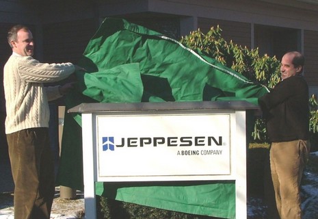
As noted earlier today, the deal went down. Above is the scene this morning at C-Map USA’s Mashpee, Massachusetts, office as Operations Manager Chris Cox and General Manager Ken Cirillo unveil their new sign. Similar events took place at other C-Map offices around the world, and a press release went everywhere. The latter is a bit vague, but a Jeppesen spokesperson at the Denver headquarters gave me a little more color on what this acquisition may mean to marine electronics. The most specific item is that Jeppesen Marine’s recreational division, i.e. Nobeltec, will be integrating C-Map cartography into its products, though it may take six months or more, and the fate of Passport Charts is “yet to be determined”. Otherwise C-Map will be “business as usual”—i.e. same partners, sales outlets, and customer support facilities—at least during the six months it will take to integrate the company into Jeppesen. And the notion that C-Map’s hardware manufacturing facilities were not part of this deal, posted here back in August, was also confirmed. As for that distinctly non-marine logo, the spokesman said they are working on a new branding scheme, but it’s hard to give up the plane after such longterm success serving that market. In fact, Jeppesen supplies 80–85% of commercial aviation operators with not just cartography, but weather, routing, and other essential data. At one point, the company printed two billion sheets of paper per year (!), though now, of course, this data has largely gone digital. Jeppesen is obviously an aviation powerhouse (and so was C-Map in the marine world), which is why the ad they’ve been running in some of the commercial marine magazines—now modified for C-Map’s home page—has weight. It reads, “What happens when a company with more than 70 years of experience pioneering navigational and operational information management solutions for aviators enters the marine market?…The game changes.” But, despite the hints, I guess we’ll have to wait to see exactly how.
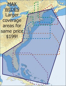
It’s a happy day for navigators when C-Map is running out of adjectives to describe how large an area is covered by its latest chart cards. The press release is not online yet (update), and C-Map’s Web chart catalog doesn’t yet show them, but last week the company announced that in 2007 Wide-size cards will cover about five times the area for the same price. That means, as shown right, that $199 will get you every chart from the Canadian border through the Bahamas and up the west coast of Florida, with all Max features like animated tides & currents, custom C-Marina charts (like below, which I like a lot), and photos of inlets/harbors. $249 MegaWide cards will also get super-sized, one purportedly covering the entire East Coast, Caribbean and the Gulf Coast. Another covers the Gulf of Mexico, the Caribbean and all of South America, and a third covers the entire West Coast of Canada and the U.S. If you visit C-Map this morning you’ll see that the Jeppesen deal is now official, which I’ll have more on later today.
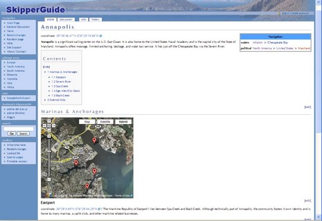
If you followed my PS’s to the ActiveCaptain entry, you know that the site got quite a drubbing on certain forums and newsgroups, much to the amazement of people like me who actually know AC’s proprietors. Oy! But those threads did lead me to check out some other sites that allow cruisers to create/review POIs for each other. I was somewhat familiar with Marinas.com, but didn’t realize that it has by far the best aerial photography of my homeport I’ve seen anywhere, in fact great photography of ports and lighthouses all over the planet. Registered users can write reviews of marinas but there’s no way to correct marina data, which is too bad as a lot of it is flawed. For instance, the flat statement that “The Camden Yacht Club is private, but may be able to offer reciprocal privileges to members of participating yacht clubs” is flat wrong; the Club is welcoming to all cruisers. SkipperGuide is quite the opposite of Marinas.com; it’s very light on content, so far, but users can potentially add almost anything they want, in “wiki” fashion (which it is). In fact, it’s possibly too ambitious; whereas SkipperGuide attempts to cover the whole world of cruising, starting without even a flawed database, it’s going to take a lot of user input to make it seem at all useful. Check out Annapolis, for instance. On the other hand, this site—like the interesting online waypoint, and more, manager POI66–integrates with Google Earth. Are there other sites like this? Will one become the “ebay/Amazon” of marine POI reviews?
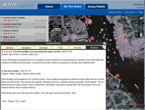
My column about the sorry state of marine Points of Interest (POI) info is now out in the February issue of Power and Motoryacht (and now online). At the end of it I make note of a cool new Web service that was about to go live and that could go a long way toward solving the POI problem. Well, ActiveCaptain.com is really here, and it’s even better than the alpha version suggested. The site was created by the talented Jeff and Karen Siegel, and its goal is to let all of us contribute details of marina services and give them ratings. Other useful POIs, like anchorages, will be possible soon. The Web interface, using Yahoo maps and sat photos, is wicked slick, and totally free. And it will remain free, as the Siegel’s business plan is to develop and sell software that will enable mobile devices like cell phones to easily access ActiveCaptain, while leaving regular Web access free, even of advertising, so that hopefully a critical mass of “captains” will contribute to it. Smart! But there is an ironic twist to this story. My secondary objective with the POI column was to promote my home harbor of Camden, Maine, which has a largely undeserved reputation as a tough place to find a good and reasonable berth. Well, wouldn’t you know it, Jeff Siegel himself was the first person to rate a certain Camden marina and apparently it’s the only negative one he’s written so far! But that’s how it works when when conversations gets real. I’ve already detailed and rated Camden marinas myself (full size screen shot here), and am confident that even what’s there now, week one of ActiveCaptain.com, is more accurate than what you’ll find on any electronic chart or in any guide book. Now there’s probably another dreary winter weekend ahead, so take some time to register at ActiveCaptain and add your two cents about Camden or any other harbor you’re familiar with. The more, the better.
PS, 1/27: Oy, some of the cynics at rec.boats.electronics and rec.boats.cruising have gone paranoid about how ActiveCaptain’s sinister purpose is to “harvest” e-mail addresses. Ignore them! I am absolutely confident that the Siegels will not misuse anyone’s e-mail. By the way, much as I appreciate those newsgroups, they certainly can be sources of misinformation. Interestingly, the ringleader of this particular nonsense is a regular poster/windbag named “Larry”, whose asinine rants about NMEA 2000 already made Panbo. Always ignore Larry!
PS, 1/28: Oy again; the righteous moderators at SailNet even axed a simple announcement of ActiveCaptain. Isn’t it ironic that if the Siegles had included an obvious revenue source like Google ads on the site, these paranoids would probably be excited about it? Haven’t they noticed business models that include a significant ad-free element, like, say, GoogleEarth?
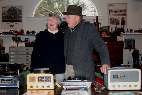
Monday I had the great pleasure of touring the New England Wireless and Steam Museum with two of its founders, Nancy and Bob Merriam. I got there by tagging along with Jim Fullilove, editor of NMEA’s Marine Electronics Journal, and he was there to work on a story for the organization’s upcoming 50th anniversary. You see, Nancy and Bob were two of the dealer/installers who formed NMEA way back when. Hence the table full of early RDFs, AM radios, fathometers, and radars they’d pulled up from the Museum’s basement. The Merriams are a deep well of knowledge about that gear, and the early NMEA, but their real passion is the very dawn of marine electronics a century ago, and the museum reflects that. Below, for instance, is the very first wireless communications station—building and all, and in operational condition. Check the giant Morse key, capable of handling 20kw without a relay. What you can’t see in this photo is the intense blue sparks generated by the Massie spark transmitter upper left. The museum—which has all sorts of other early wireless artifacts, not to mention a major collection of working steam engines— is only open by appointment and best visited during the warmer months, but very much worth doing. Meanwhile this novice “sparkie” is very much sparkless, down with the flu while visiting New York City, and regular posts may not resume until next week.
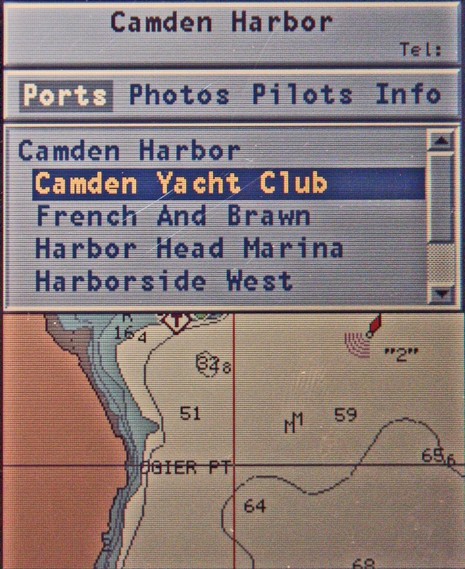
Following my whining about the clumsy POI interfaces seen on many plotters and charting programs, Navionics sent up a powerful handheld they make (but would rather not advertise here, as it’s only available in Europe). They’re proud of how easily POIs can be found and browsed, and well they should be. There are at least two ways to get a list of local marinas, for instance, and the one below graphically points them out as you page through. Once selected, the particular marina's phone # goes into the title bar at top and right arrowing through the categories shows you what photos, Pilot book, or other info is available, and then you can drill down. When you get to, say, “other services” in the “info” section, nearby businesses with their own POI info are in blue and clickable. There are almost no dead ends, i.e. the interface doesn’t let you click for more information about something if there isn’t any (a gripe I have with Raymarine’s access to this same POI info). At any rate, Navionics made its point; a much better way to get at all this data is possible on even a small plotter. But that doesn’t make the data any more accurate. For instance, that’s not exactly where the Camden Yacht Club is (below). But some good news on that score is coming later this week. Posting will be jagged, though, as I’m on the road to points south (a little south).
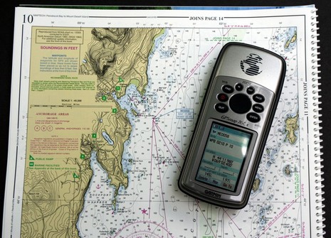
Last Fall I tried Captn. Jack’s Garmin 76Cx bundle, and liked it a lot because it not only includes a Maptech Waterproof Chartbook of your choice, but comes with all the printed waypoints already programmed into the GPS. Turn it on, pick the desired waypoint from a list, and—bada bing—you have a solid connection between a traditional chart and electronic positioning. Given your distance and bearing to the waypoint, you can simply eyeball where you are, helped out by all the course lines Maptech lays out (bigger picture here), or you can use dividers and parallel rules for more accuracy. I think this is the nuts for beginners and traditionalists, not to mention small boat navigators and lazy old coots (like me). And whereas Chartbooks also come with a CD of digitized pages and a basic charting program, and you can get full detail charts for the 76Cx (or the larger Garmins in the other bundles), this kit gives you a couple of ways to grow. It’s also a good example of how a retailer can add serious value to some already good products. All of which is why this was one of my Sail magazine Freeman K. Pittman Award picks, just announced today. I notice that Motor Boating included it in their “Gear of Year” too. Now, wouldn’t it be cool if Maptech, and other chart/guide publishers, made their waypoint files available for anyone to download? And it might sell more printed products, so there’s some motivation!
I’m feeling so old today. First I saw this Casio Waveceptor watch going for $25 on Woot. Five times a day the thing listens to WWVB, the time signal station in Colorado, and adjusts itself to atomic precision. I remember in the 70’s laboriously tuning into that station and tracking errors in the various expensive chronometers on a whale research vessel where we were using celestial nav to map and stay safe on the big banks off the Dominican Republic. Then I hear that Darrell Lowrance has retired and a fellow young enough to be my kid has taken over as new CEO of Navico (Simrad, Lowrance, etc.). And early this week old time big yacht installer Larry Smith Electronics suddenly shut its doors. I suspect some sort of financial mismanagement was the cause, not lack of business. Meanwhile, this old guy’s phone is busy as companies prepare to strut their stuff in Miami.
The first LightShip I tested had rather stiff and ineffectual suction feet and kept falling off the south window I stuck it on so that its little solar panel would charge up its Ni-Cad battery (no doubt the winter chill coming through the glass didn’t help). Then one last fall killed it dead. But that’s how I found out that SolLight had upgraded the suction cups, and now test unit #2 is stuck firmly to my office window and working like a champ. You can switch between red and white LEDs, and there’s even a light-actuated off switch if you want to just leave the sucker on all the time. At $15 a piece, less in volume, I’ve got to believe that lots of LightShips are going to go boating. There’s more detail here and, by the way, the SolLight bottle lamp I tried almost two years ago is still working fine.


 It’s a happy day for navigators when C-Map is running out of adjectives to describe how large an area is covered by its latest chart cards. The press release is not online yet (
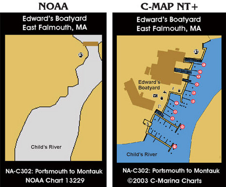


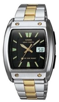 I’m feeling so old today. First I saw this Casio Waveceptor watch going for