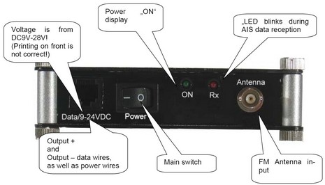
Well, whereas I stirred up a bit of a Class B AIS hornet’s nest yesterday, I may as well keep at it! It seems to me that another repercussion of Class B’s 30 second (at best) dynamic data rate is that the inexpensive “single frequency” receivers are only going to see Class B targets once a minute (at best). I put “single frequency” in quotes because I’m realizing that the nomenclature for these receivers has gotten pretty confused. For instance, when I characterized the EasyAIS receiver as “dual frequency” back in April, I meant that it could listen to both AIS frequencies simultaneously. Now I realize that I was probably wrong about that, though EasyAIS is not exactly forthright about its receiver's specs. The company site calls it a “real 2 channel receiver”, which, when you think about it, does not mean that it listens to both channels simultaneously, and an English install manual I found (PDF here) doesn’t mention reception modes at all. Meanwhile one retailer, YachtBits, also calls it a “double superheterodyne receiver” which sort of sounds like parallel reception on both channels, but another notes that “every few minutes it switches automatically between both channels” (Busse Yachtshop). And Y-tronic, a reliable source in my experience, says that the EasyAIS “monitors both AIS frequencies by alternating between both channels”, further noting that that it is quite well made. Conclusion: I don’t think that the EasyAIS listens to both channels at the same time, and therefore will miss 50% of the AIS messages sent out in its area. I also think that the industry should settle on some terms for these receivers and use them to properly inform customers.
PS, 12/8: It’s good to see that NASA is clear about its AIS Engine: “The unit can receive ships on either the A or B AIS channels. In default setting it alternates between the two channels.” But then in the very next paragraph NASA claims that the Engine outputs to a “NMEA 2000 input.” It absolutely does NOT, and, moreover, I’ve heard that its serial NMEA 0183 output is so flawed that it won’t drive the opto couplers that are a feature of many good multiplexers. Sigh.
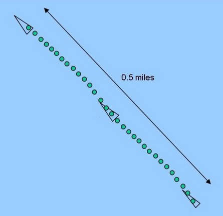
This diagram—borrowed from Dr. Andy Norris’s valuable AIS/06 conference presentation—illustrates various possible target presentations for a vessel doing 30 knots over a one minute time period. The green dots roughly represent both radar paints and Class A AIS messages received. (A normal 24 rpm radar would, of course, hit a good target twenty-four times in a minute; a Class A transponder going this speed sends out dynamic data every two seconds, or 30 times per minute.) But the triangular icons indicate what a smaller vessel (possibly a poor radar target) carrying Class B AIS might look like, given B’s maximum dynamic data speed of 30 seconds. Obviously the target could move a quarter mile between plots, making like a mexican jumping bean if your plotter/ECS is zoomed in very far. Now there is an obvious, though processor intensive, way to smooth over Class B’s relatively slow data rate, which is for your plotter or ECS to calculate DR positions for each target between actual AIS fixes. I know I’ve been shown at least one PC-based product that already does this, but I can’t remember which one, and I don’t know if any plotters do DR (in an all-Class-A world it doesn’t matter as much). So please help me—either via comments, or e-mail—build a list of the AIS viewers that do or do not DR targets.
PS 12/7: Well, this DR idea turns out to be much more controversial than I realized. Apparently only Transas, which only seems to sell ECDIS these days, currently does DR calculations on AIS targets, and some developers have serious reservations about adding this ability to their own AIS target plotters:
“My opinion is that a DR feature in between AIS fixes presents some VERY SCARY Safety Concerns. I have heard that this issue has also been raised in the IEC ECS meetings. For example, what happens if the AIS Target you are tracking changes course after an update is received and then an extended period of time elapses before another update to the to the new ship's course and speed are received??? The vessel may have made a course change which was not received by you and you may choose to make a critical navigation decision based on incorrect DR Position information.”
Others feel that, “The DR position is likely to be closer to where the boat actually is than the last actual position which is crucial for collision avoidance. You avoid a collision by anticipating where a boat will be, not where it was 30 seconds ago.” There may be a graphic solution, say changing the color of an AIS target’s “bread crumb” track to indicate fixed and DR positions. I will definitely collect more info and opinions, and share them here.
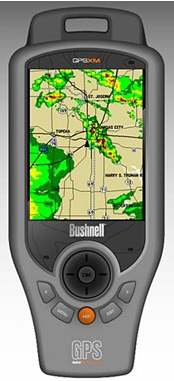
EliBoat made a good catch last week, spotting this Bushnell ONIX400CR GPS and XM handheld. The specs, as spied out by the sat radio blog Orbitcast, look impressive—waterproof, 3.5” screen, XM weather & audio, aerial and satellite photo overlays—and all supposedly retailing for $500 when the product ships in February. That’s a big discount from the Garmin handhelds that offer this same great ability to carry your XM subscriptions from boat to car to house, etc. Mind you that Bushnell shows no interest in the marine market; its thing is hunting, as shown by its Web write up for sister product ONIX200CR. Still, I want to try one and see if it might make sense, even without nautical charts, as a boating accessory. This product, by the way, is an ‘honoree’ in the Wireless Peripheral category of the 2007 CES Innovations Awards, always a geekerrific list.
More good news on the cost of marine electronics front: Navionics is apparently going from XL3 to XL9 Gold+ chart cards, three times the area for the same $200 price. That’s the whole East Coast and Northern Bahamas on one card, with full NOAA chart detail (unlike the Silver all-one-cards), plus “enhanced port services” POIs (flawed though everyone’s may be), coastal roads, and a mail-in coupon for a free Fish’n Chip bathy card. This price drop is not on Navionics’ Web site yet, and may not be effective until 2007, but Peter James of Jack Rabbit Marine has the scoop on his new blog, askjackrabbit.com. A blog by a guy who professionally installs marine electronics? Now there’s some really good news.
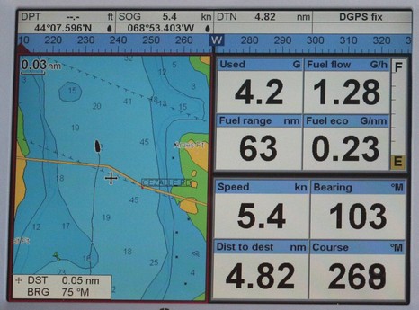
As previewed at METS, the Northstar family has no less than 29 new members, which means that the brand now offers full product suites for most any size boat. Of course most of you won’t even need the bigger image to realize that these are very similar to existing Navman products, only with black buttons instead of blue ones. In fact, my understanding is that most of the 27 ‘new’ Explorer units are exactly like their Navman counterparts, though a few have upgrades like higher resolution screens, and—good news—none have risen in price. The one completely new unit is the M84, at right above, which is an 8.4” version of the Northstar M120, which is essentially the same as the Navman 8120 I’ve been testing. In other words, both of the new M Series units should be able to hook up to either SmartCraft engines or stand alone fuel flow meters to show a nifty screen like the one below (never mind the road shown running over the Fox Island Thorofare—just another one of those chart anomalies we should be on the watch for!). So far only the M84 is detailed on Northstar’s Web site, and I believe that all these new relatives may retain the Navman name in certain countries like South Africa where it’s much better known than Northstar’s. Finally, whatever the name, most of these plotters have recently acquired excellent AIS display ability, to be illustrated in a coming entry.
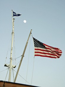
I spent the winter of 1972 living in New Orleans and working on oil field supply boats, acquiring a huge fondness for the former (not so much the latter). But I haven’t been back until this week, and naturally was very curious about how well this wonderful city is recovering from Hurricane Katrina. Well, of course it depends a lot on who you talk to, and where you aim your camera. The shot above, bigger here, shows some wrecks still lingering in the same Lake Ponchartrain marina we saw in before-and-after satellite shots back in 2005. Even right there on the spot it’s hard to imagine the ferocious weather conditions that could break off one boat’s keel on a dock, impale another with a piling. But you can see that the nifty boathouse/apartments in the background are getting rebuilt, and a turn in either direction would show many new or fully refurbished boats and docks. The “we will survive” spirit particularly showed at the Southern Yacht Club—going full steam in temporary buildings under a resurrected flag mast, brand new club house and facilities in the works.
And the Big Easy is still very much a paradise of spirited music and food. Even an oyster po’boy from the Convention Center commissary was a total treat. The French Quarter’s Bourbon Street may have gotten more touristy and debauched in the years I’ve been away, but there’s a certain evolved brilliance there. It’s closed to traffic now, and dozens of clubs compete for your attention with various entertainments, drink deals, etc. However, there are no cover charges or waiting lines; you’re free to wander in and out of most any of them, even nursing a large take-out beer, like it’s all one huge club. Laissez les bon temps roulez, and go enjoy New Orleans when you can.

 EliBoat made a
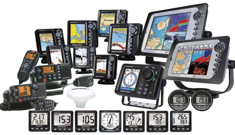

 break off one boat’s keel on a dock, impale another with a piling. But you can see that the nifty boathouse/apartments in the background are getting rebuilt, and a turn in either direction would show many new or fully refurbished boats and docks. The “we will survive” spirit particularly showed at the