How about a 62’ sailing cat with an interior like a sleek apartment and the performance of a carbon racer? Sailing Anarchy has the story here, including a larger version of the picture above, in which you can better see all the Raymarine electronics. I’ll bet those big displays are E-120s, which have XVGA out ports, and thus that 42” LCD TV may be be set up to repeat one of the E screens. I’ve seen a Gunboat 42’ in a stiff breeze on Chesapeake Bay and she was flying. Check out the video at the company site.
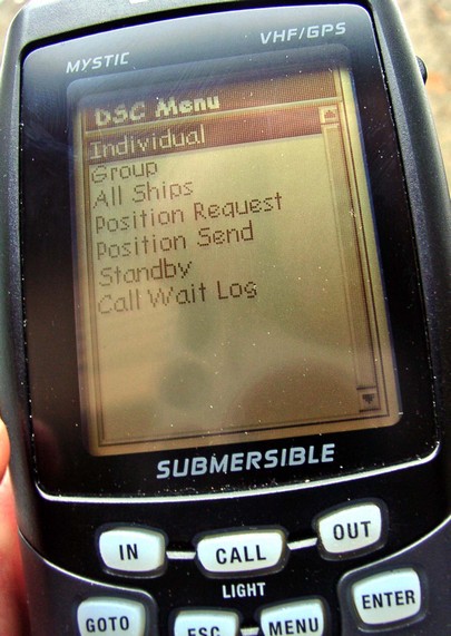
When I had lunch in Miami with the Sea Smart folks, they showed up with a Mystic, the somewhat weird but wonderful VHF/GPS hybrid that Uniden introduced about three years ago. I tested it then and was very impressed with design, build, and performance (gave it an FKP award, too). I still am, and now you can buy one for $300, or $390 with all U.S. Charts. (But note that Magellan Blue Nav charts are getting old, and you can only load one small area at a time into the Mystic).
Think about what the Mystic would give you in combination with a Sea Smart account. Where ever you went within 5 watt VHF range of the coast stations, you’d have live operator access, phone service, web tracking, and DSC distress calling in addition to regular VHF comms and a little B&W plotter. Plus you can plot other DSC radios on a Mystic, and vice versa. The thing’s too big to swing on your belt but easy to lug from boat to boat, or across an island. I’m hoping to see a Mystic upgrade or competitor someday, plus a bunch of smaller handhelds with GPS/DSC built in, no plotting. (But I do not know of anything about to happen).
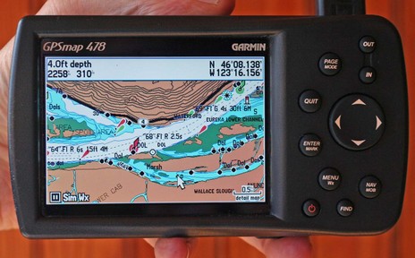
I suppose it was predictable, but it’s still amazing. The Garmin 478 above has all the XM Weather and Audio abilities that distinquished the 376C, and it comes loaded with all U.S. charts and all U.S. and Canada road maps. It’s fast too, even the ‘Find’ command is not slowed up by what must be a zillion POIs, nav aids, intersections, etc. stored somewhere in that little casing (and hence I’d bet that Garmin has sped up Find in the first all-U.S.-charts 192C I tested last summer).
Not that the 478 is perfect, even if there is nothing like it out there. For instance, these are the new G2 charts, but apparently the 478 will not be able to show the vaunted perspective view. I do gather from the spec page that it will show the photos available on G2 cards, and the screen above (bigger here) does look richer than regular BlueCharts. But, as good as this screen is, I find myself wanting to plug the 478 into a bigger monitor, maybe use a wireless keyboard and mouse with it too. The unit lets you use an expensive XM subscription anywhere you go but in some of those places, like a boat, you may want to expand the system. Just a thought, probably inspired by how rapidly this unit has evolved over the years.
I should also add that the Panbo reader who recently complained about the “Surface Wind” coming from XM to this machine was right; it’s old. He tells me that Garmin has acknowledged the problem and is working on it, but I also noticed this time around that you don’t get predicted wind and wave model data, something the new Sirius Marine Weather is very good at.
Garmin also announced a new pair of radar scanners this week, this time inside a smaller, 24” diameter casing, and with more emphasis on the digital processing going on in there. Finally, though Garmin hasn’t yet promoted it, many of its new plotters apparently do support AIS. The 478 is not one of them but I think I’ll soon get the chance to try it on a 3210.
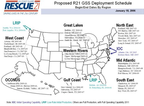
Well, so far a very small sampling of Panbites (?) is not too excited about Sea Smart. But I am. I think it may well become a “no brainer” for offshore fishermen, long distance coastal cruisers, and others, especially once it’s fully rolled out. I for one am tickled that at last there’s a service that makes good use of DSC. Especially as I’ve been in touch with the U.S.C.G. again, and the latest on Rescue 21 is discouraging. At least they've finally got a revised implementation schedule—above, and bigger here
—which is better than the situation I wrote about last year. But check it out. Full implementation of R21, once expected by 12/2006, is now set for 2011!
Now Sea Smart is not meant for distress calling, but its call center will be able to hear DSC distress calls and relay them to the Guard if needed. I like that, and think its another reason to wish the service well. But there is a contrarian view, expressed to me by a couple of you via the back channels. There have been issues with Sea Tow and other towing services over salvage claims—in fact I once wrote about such a questionable claim, and then about all the follow up letters. So cynics theorize that Sea Smart’s long range coastal VHF network will give Sea Tow franchisees a head start on possible salvage operations. My take:
* Sea Smart might make any towing service better because it will give you a more reliable way to get a call through or get help from an operator, and the operators will know exactly where you are, even if you aren’t sure.
* Sea Tow especially gets better because its dispatch center is in the room next to Sea Smart. (And the combined subscription package, $262, is going to appeal to many).
* Every boater should learn exactly what the difference is between towing and salvage.
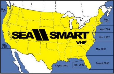
As explained a bit yesterday, Sea Smart has taken over the infrastructure—towers, radios, and marine operator licenses—that MariTEL shut down in 2003. As shown above, from seasmartvhf.com, the service is live on the west coast of Florida, coming to the NJ/NY/CT shore soon, and supposedly the whole U.S. coast by late 2007. Like the old service, Sea Smart is primarily offering ship-to-shore phone calls, but at a flat rate that’s much simpler and more reasonable than it used to be. Range, of course, will usually outdo even the most souped up cell phone setup, and the operators can supposedly supply “information on the nearest fuel dock or restaurant…” (though I’m not clear about far the Long Island, NY, call center is able or willing to go with this sort of ‘concierge’ service).
At any rate, current Sea Tow members get unlimited calls, including U.S. long distance charges, for $144 per year, while non-members pay $204. Note that each call is limited to five minutes and the service does not support shore-to-ship calls. (Note also that the shore side of your phone conversation can be heard by anyone tuned to the channel, and, if this service takes off, calling slots could get scarce). Sea Smart had a temporary station set up at the Miami show and I tried a call to my cell. It was somehow pleasingly retro to place it with a live operator and the voice quality was quite good.
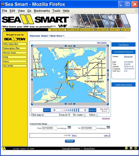
Getting the Sea Smart operator is just a matter of selecting the right local channel (the possibilities are: 24–28 or 84–86) and holding down the transmit button for 5 seconds, listening for an automated confirmation message, and then holding the button for another 5 seconds. DSC is not actually needed to connect with the operator, but Sea Smart requires that you have an MMSI along with a DSC radio attached to a GPS. That means that once the operator gets your MMSI he or she can poll your radio for a position. Sea Smart seems to have two reasons to push DSC. One is that when help is needed the call center can then very easily give good position information to the adjoining Sea Tow dispatch center. Another is that DSC polling lets Sea Smart include Automatic Vessel Location (AVL) as part of the service. The screen shot below, and bigger here, shows you how, say, your family might check on your fishing trip.
I have even more noodling on this subject but I’m really curious what you all are thinking. Might you sign up for Sea Smart when it goes live in your area?
Researching Sea Smart is getting me nostalgic. Back in the 70’s—when I was running a daysailer, delivering yachts, dragging scallops…out on the water a lot— Camden Marine was a tiny independent company with an antenna on a local ‘mountain’, a license to operate 2 “public correspondence” VHF channels, and a few staff who took turns handling the calls from one’s home. Back then, way before cell phones, they had a nice business patching through calls from summer cruisers, lobstermen, etc. They also had such good range that they sometimes relayed distress calls to the Coast Guard. The operators were easily the best known voices on the Bay, and it was a comfort to know that they were almost always listening. (Plus you could hear both sides of any phone call, and listening in was a popular anchorage entertainment.)
You may know the rest of the story. Cell phones really hurt the business, but then an ambitious company called MariTEL bought up almost all the coastal stations (plus more spectrum from the FCC), centralized operations, and made extravagant plans to improve the technology, enabling DSC driven automated dialing, e-mail, etc. Six years ago, I was writing excitedly about MariTEL claims that it would soon be able to hear DSC calls 50–100 miles off the entire U.S. coast and its strong hints that the Coast Guard was going to contract their service in order to quickly adopt DSC distress call ears. But before some of the hype even got into print, the general telecom boom came crashing down, and MariTEL’s big plans with it. In 2003 they even shut down the regular marine operators (and I wrote about their rise and fall with some bitterness here).
Well, guess what? MariTEL still exists, at least as a spectrum and tower owning skeleton of a company, and Sea Tow is licensing its VHF assets to create a very interesting service called Sea Smart. The marine operator is back, though this time around she’s apt to have a “New Yawk” accent. More soon.
Today I realized that Garmin has put up more information about their second generation BlueCharts, including the screen shot of the perspective view above, and the unusual top-down high-res photo below. Garmin announced G2 in November along with a boat load of new gear, which is all now coming to market. I’m on the list to see the G2’s on a couple of new plotters, and, of course, will report here. I also came across some surprises on Garmin’s Web site, some seemingly only accessible by randomly appearing links: a new blog; a very cool looking Smart Phone mapping software/data system with combo Bluetooth GPS, speaker phone, and cell mount (whew!); and a mapping program for certain cell phones already GPS enabled. There’s also Nuvi. No location awareness stone unturned!
I’m glad to see that Sail has posted a PDF of this year’s Freeman K. Pittman awards (downloadable from this page). In honor of former Technical Editor Pittman, every December four of us choose what we think are the most innovative, exciting products recently introduced in the category we cover. I take it quite seriously. Regular Panbo readers won’t be too surprised to learn that I singled out Garmin’s 376C with XM Weather, Navman’s 3380 autopilot, Uniden’s UM625C VHF, Navionics’s Platinum charts, and Si-Tex’s AIS receiver (which I qualified as a contrarian choice due to its poor build quality). What did I miss, or better yet, what brand new product should be on my candidate list for the Feb., 2007, awards?
Does it strike you as peculiar that Navionics is packaging their new NavPlanner software with a special multi card reader? Heck, didn’t Navionics spearhead the move to standard memory cards? Aren’t all its current products on either CF or SD formats? Wasn’t there once a rumour spread by the likes of me that Navionics was thinking of putting a free planning program on every card? That’s true, but dates to the days when Microsoft had assured Navionics that its chart files could be simultaneously protected and read using normal MS file features. That turned out to be untrue, and that’s why you need a special reader to view Navionics charts on a PC. I think the same is true of C-Map, whose charts now come on SD cards too. So it goes. Using standard memory cards in plotters still makes it easier to do firmware updates and save waypoints, and also reduces overall chart card costs. NavPlanner, by the way, is still not shipping, but “very close”.
Generally I’m pretty good about sticking to marine electronics, but today I’m going slightly off topic. For one thing I’m looking for a new cell phone and service contract, and I’m betting Panbo readers may have some helpful opinions. I’m thinking of dropping my venerable Nokia 5165 with AT&T analog and TDMA service in favor of Cingular GSM and a HST Wizard, aka the 8125 above. It’s a hell of a phone, and would let me try at least one of the wireless e-mail and web services that some boaters are becoming fond of (nicely combined with WiFi), not to mention Windows Mobile marine apps like the coming ActiveMap. I also need a better phone because I’m going to be spending a lot of April and May in Boston getting some medical treatments (one of those prostate problems us old guys run into). On a cheerier note, I’m pretty much set on GSM because it’s finally gotten to midcoast Maine and also because my daughter thrillingly reminded me of its global capabilities by calling me from a boat on the Ganges River last week. She just bought an Indian SIM card and popped it in her T-Mobile Sidekick II; the call quality was superb. She’s why I went to India in 1999, when she was an exchange student, and now she’s briefly back there as part of a course called Covering Religions that she’s taking at Columbia Journalism School. A hell of a course! Check out her contribution to the class blog. (She’s the one with magenta forehead, and she makes me proud!)


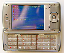 Generally I’m pretty good about sticking to marine electronics, but today I’m going slightly off topic. For one thing I’m looking for a new cell phone and service contract, and I’m betting Panbo readers may have some helpful opinions. I’m thinking of dropping my venerable Nokia 5165 with AT&T analog and TDMA service in favor of Cingular GSM and a HST Wizard, aka the 8125 above. It’s a