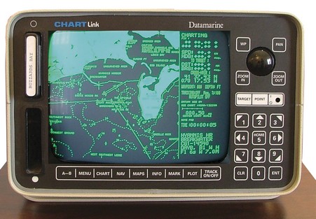
C-Map owns this ‘historic’ machine, which is supposedly the first chart plotter (bigger here) ever sold in the U.S. That was around 1985, when Navionics founders Giuseppe Carnevali and Fosco Bianchetti developed the first crude vector charts and this Datamarine-labeled plotter to show them. (Bianchetti soon went off to found C-Map). Wasn’t it about 5 years later that the first PC charting program came out? At any rate, we’ve come a hell of long ways in 20 years, and Carnevali and Bianchetti—who still run their companies—deserve some of the credit.
Now, would anyone care to predict what marine electronics will look like in another 20 years? 10? 5? With that, I wish you all a wonderful new year.
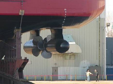
Let me say right off that I’m a big fan of the U.S. Coast Guard. But they do screw up sometimes. The latest was doozy. A couple of weeks ago the brand new cutter Mackinaw, soon to be the Guard’s largest Great Lakes vessel, was making a grand entrance into Grand Haven, Michigan, when all of a sudden it did a 90 and rammed the sea wall. Only the sea wall and bow were injured, but the poor vessel earned a nickname that may be hard to live down. There’s even a video, and, no surprise, the skipper got “temporarily demoted”. The cause of the accident was inexperience with the controls. As you can see above, the Smackinaw has new fangled azimuth drives instead of rudders. It also has what sounds like a super high tech command and control system, judging from the verbiage on her Web site:
“Ship control is provided at 5 conning stations; Master Ship Control Console (MSCC), port & starboard consoles in the Pilothouse, the Engineering Control Center (ECC) and Aft Conning station. The Main Ship Control Console includes the Integrated Ship’s Control System (ISCS) provided by Kongsberg. The ISCS includes; Electronic Chart Display Information System (ECDIS), DGPS, Loran-C, Automatic Radar Plotting Aids (ARPA), ATON Information System (ATONIS)/Automated ATON Positioning System (AAPS), a dynamic positioning system, autopilot, a doppler speed log, deep and shallow depth sounders, forward scanning sonar, extensive meteorological sensors, VHF, ADF, IFF, and a voyage data recorder. All conning stations will have the same intuitive user interface, the same panel layout, and menu system. Route plans, mariner’s notes, charts, radar video and vector presentation are shared between the systems.”
So this is one of those stories that electronics skeptics can chuckle over. And I’ll bet there’s more than chuckling happening on the original Mackinaw, which has been in service since 1944 and is nicknamed Mighty Mac.
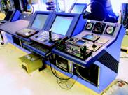
Here’s the nav station on Wild Oats, a brand new 30 meter maxi that just set a record for the Sydney-Hobart race. It’s obviously a carbon fiber construction, like most everything else on the boat. It’s interesting that as new and highly designed as this vessel is, the electronics are still a hodge podge of different brands with different looks. I spot B&G displays on the overhead (probably hooked into the new Wave Technology Processor), what’s probably a Raymarine E120 (radar and chart plotting?), and what look like Icom VHF and SSB radios. I’m not sure what the lower right display is (an MX Marine AIS?), and of course that’s a big PC monitor on center (Deckman and weather programs?). Operating that keyboard in the well must be awkward, but maybe it comes out? PS: There are more of these Andrea Francolini interior photos worth checking out at Scuttlebutt.
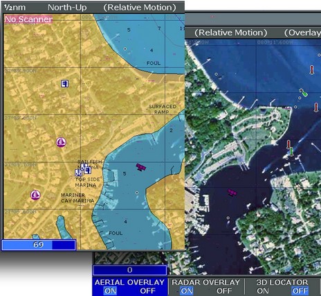
The chart game just gets more complicated, and interesting. There’s nothing on the Web yet, but last week C-Map announced the Pro version of its Max chart format. A couple of weeks ago I got a peek at it running on Northstar’s amazing new 8000i system, about which I will soon tell you a lot. One claim of C-Map is that Pro “delivers the most ‘paper chart like’ display ever seen from a vector chart.” I’m not sure how they’re doing it—new fonts, colors, object arrangement, maybe all of the above—but the charts looked really good. I didn’t get to see the photo map blending and 3D views seen above and below (in company screen shots), but look forward to at the Miami Boat Show where Pro will officially debut. Other features include “one button” chart updating and a weather overlay data system. Of course, all the regular goodies in Max are also included. Pro will be a premium product costing about $390 for 'MegaWide' areas, and so far only the 8000i supports it.
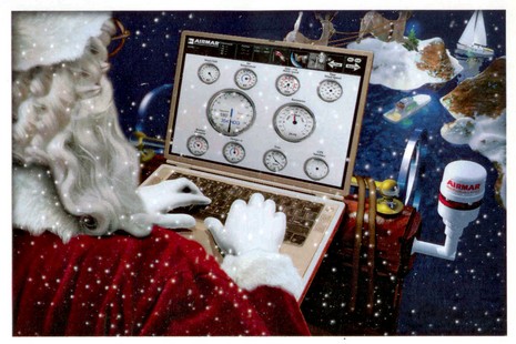
I get some wonderfully strange Holiday cards. Not every marine electronics company tries to make their’s thematic, or even sends one, but still I get excited every time I open an envelope. So far this year’s stand out is Airmar, which has Santa checking gauges on the PC version of Weather Station.
So here’s a geekish Happy Holidays to all of you. I’m off to New York City for a few days (how convenient that the buses and subways went on strike at 3am this morning!), back next week.
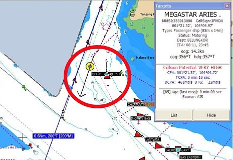
It’s great that Terry Sargent has joined our discussion about the AIS-documented near miss he had in the Malacca Straits. I really admire his desire to thoroughly debrief his experience, and his willingness to share it with the rest of us. Terry has also expanded his web page about the AIS hardware and software he’s using. Above is a clip from a screen shot he took while transiting the Singapore Straits, with the red circle added to highlight Valhalla and the nearby passenger ship Megastar. He notes that his SOB freeware is calling the collision potential “VERY HIGH” even though he and the ship are almost beam-to-beam during a standard port-to-port pass. That just means that the logic behind SOB’s warning is imperfect. Note also that SOB’s AIS data window is unusual in that it lists CPA as a position with a separate DCPA to give the distance between vessels during the CPA and also DTG for the distance to go (until you arrive at the CPA). Calculating just CPA (as distance) and TCPA is the norm. SOB is trying to give as much information as possible, which is admirable, and I’m sure a user would get used to its style. By the way, here are some more AIS screenshots—this time using Nobeltec on the North Sea—posted by a Kees Verruijt on his Scanner 391 site.
How about these idiot lights? Actually this is called a “mimic” panel, and it looks darn useful to me (bigger here). This particular one is from Mochi Craft in Italy, and is especially dense with information and controls. I do wonder if there are current sensors wired into those nav light indicators, so that they blink if a bulb fails (easy enough to do). And, yes, I think that is real leather (it sure felt like butter), as you can see more of below, and bigger here, along with a good looking Man engine display and an ever so retro cigarette lighter.
PS. No Panbo tomorrow as I’m off to visit Northstar, but I think I will be returning with an interesting report.
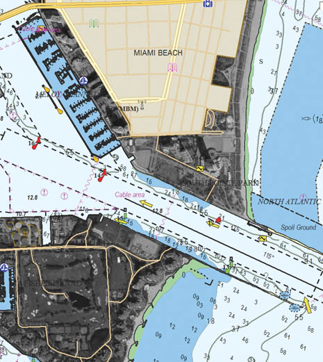
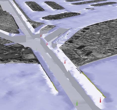
I recently took some screen shots of DAME award winner Navionics Platinum, which is surprisingly simple to do on the Raymarine E series. You just hold down the ‘data’ button until you hear a beep, and a full resolution (800x600 pixels, in the E120’s case) .bmp file will be saved to the CF card. At any rate, the full res version of the image above is here. That blue line on the left side marks the angle of view that I’ve set in the 3D image to the right. You can rotate and move around in that 3D view all you want, plus change its zoom and pitch, or you can simply synch it to the chart view.
Note too how the area around the channel is much more detailed than the chart soundings; it looks like you can even see the bite marks of the dredge. Navionics, like everyone else, is pretty tight about where it sources data, but I know that the Corp of Engineers does extremely high resolution surveys during dredging projects, and I think that’s what we’re looking at. {Wrong, it turns out; after speaking with someone at Navionics I think that it’s more likely that this is just an ‘effect’ that Platinum applies to any dredged channel.} The left window, by the way, is a blend of photo map and chart, as I discussed earlier. I’ve notice unfortunately that all the photo maps north of New York State are black and white, exactly like Maptech’s, which are based on USGS files (which probably explains that source). Below (and bigger here) is an illustration I made trying to show how the variable blending works. On the right side you can see how nice the color maps can be.
Whereas so many of you are interested in AIS, and so many news bits keep coming in, I’m starting a “this and that” series…
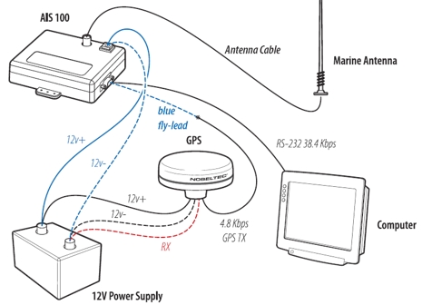
* Nobeltec has put up the best looking AIS 100 manual to date. Above is a wiring illustration, including how to pass GPS data through the AIS 100, though Nobeltec does not recommend doing so. (For them it’s largely an issue of technical support, but I also understand that the AIS 100 only passes through the GPRMC data string, which may mean that you won’t be able to see, say, how many satellites a GPS is receiving. Anyone know for sure? {The answer is yes, confirmed by GPSNavX in comments})
* Meanwhile, NASA has apparently changed the firmware in the AIS 100 so that it now automatically switches channels every 36 seconds, which seems like a good idea. Supposedly it is possible to update older units, but I don’t know how, or where you can get the update (yet).
* Navicon, a Danish company doing a lot of AIS software development, has introduced a Java-based charting program called AIS Navigator.
* True Heading, a Swedish AIS company, has developed a splitter for sharing a single antenna with an AIS receiver and a regular VHF radio. Look in Products/Accessories. They also have a new product called Blue-Pilot which uses Bluetooth to make a Class A transponder’s “pilot port” wireless. Better yet, it is supposedly able to find and correct problems in the plug installation (which are said to be common). Look in Products/AIS, where you’ll also see the Smart Radio 161 single channel receiver recommended for shore use only.
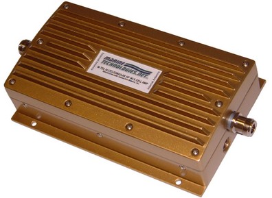
The full name is Marine Technologies and they’re coming to market with a large portfolio of marine cellular gear. At the top of the line (nearly $1,000) are wireless amps like the above, which claim to provide a carrier-friendly gain ranging from “-40 to +20 dB, 70 dB maximum”. That’s a lot. Marine Technologies is a spin off from a big Florida marine electronics installer, and the folks involved say that their technology blows everything else (i.e. Digital Antenna and Shakespeare Marine) away. One drawback to the high performance, however, is that you have to choose your amp for either 800 MHz (Alltel, ATT, Cingular, etc.) or 1900 MHz (Verizon, Sprint, T-Mobile, etc.).
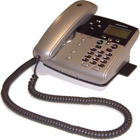
M-Tec also sells these amps in a neat package with the new and very wireless Motorola SD4500 cordless phone system. If you use a compatible Moto cell, you could step aboard your yacht and drop it into a Cell Dock where it would be charged and amplified. Your base station (above) can wirelessly connect to 3 of these docks, even pass address books, plus you can have up to 7 wireless handsets (left) around the boat using the cell lines and a regular phone line (land or satellite). I’ve written about the advantages of a “wireless wireless” boat cell system; this is wireless x 4, all from one marine source, and it looks like it will make some yachtsmen very happy. More on the M-Tec line soon.
PS 12/14: CNET just put up a pretty thorough review of the SD4500 system, as well as RCA’s Cell Docking System, which is less sophisticated but works with many more cell phone models.

 , the Engineering Control Center (ECC) and Aft Conning station. The Main Ship Control Console includes the Integrated Ship’s Control System (ISCS) provided by Kongsberg. The ISCS includes; Electronic Chart Display Information System (ECDIS), DGPS, Loran-C, Automatic Radar Plotting Aids (ARPA), ATON Information System (ATONIS)/Automated ATON Positioning System (AAPS), a dynamic positioning system, autopilot, a doppler speed log, deep and shallow depth sounders, forward scanning sonar, extensive meteorological sensors, VHF, ADF, IFF, and a voyage data recorder. All conning stations will have the same intuitive user interface, the same panel layout, and menu system. Route plans, mariner’s notes, charts, radar video and vector presentation are shared between the systems.”


 that their technology blows everything else (i.e.
 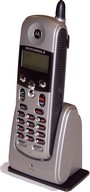 If you use a compatible Moto cell, you could step aboard your yacht and drop it into a Cell Dock where it would be charged and amplified. Your base station (above) can wirelessly connect to 3 of these docks, even pass address books, plus you can have up to 7 wireless handsets (left) around the boat using the cell lines and a regular phone line (land or satellite). I’ve written about the advantages of a “