I’m a sucker for anything that connects to a PC. The new AutoAnchor Rodecounter for the PC is an interface box that provides anchoring information for PC based applications. It is designed primarily for large yachts, with glass screen PC displays, but is also generating interest for use on smaller vessels using laptops. It features accurate rope/chain or all-chain rode counting, with pre-set calibrations for specific windlasses, a docking alarm to warn the skipper the anchor is approaching the boat, and “plug and play’ software. The company also produces units with a display. — Jeff Hummel
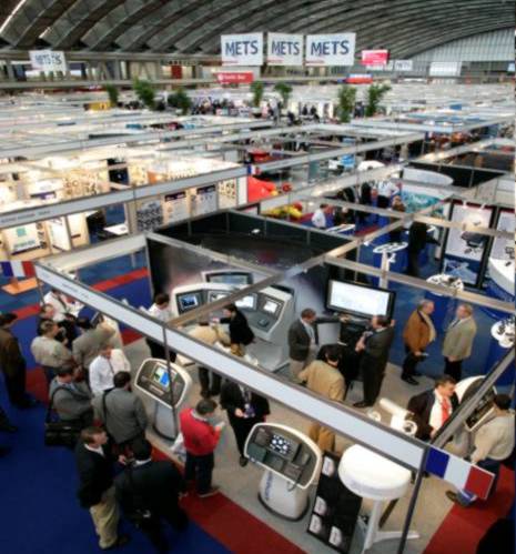
Over the next few days I’ll be posting some guest blogs from Jeff Hummel, who writes, “Over the last 10 years I’ve been making an annual trek to the Marine Equipment Trade Show (METS) in Amsterdam, Holland. The show, now in its 18th year, is the premiere marine equipment show in the world.It only runs for three days and is primarily a business to business venue, and it’s enormous with over 1000 exhibitors spread over 4 halls. Walking non-stop it took me 2 hours to cover the show.”
Jeff, by the way, has worked in marine electronics for over 15 years. He started with Nobeltec in 1995 and was instrumental in developing the Insight Radar and Nobeltec’s Passport charts. He left in 2001 and wrote a 600 page book about using the software called Inside Visual Series. Now he’s the director of Sales and Marketing at Rose Point Navigation systems, which produces Coastal Explorer and Maptech’s Chart Navigator Professional. He also writes part time for PassageMaker magazine and owns an 80ft research trawler called Sea Blazer that he is currently setting up as an NMEA 2000 test vessel.
But don’t presume you need all those qualifications to write a guest blog on Panbo! If you’ve have an interesting bit of marine electronics, or a cool helm setup, or a lesson learned, please send us a note and we’ll discuss an entry.
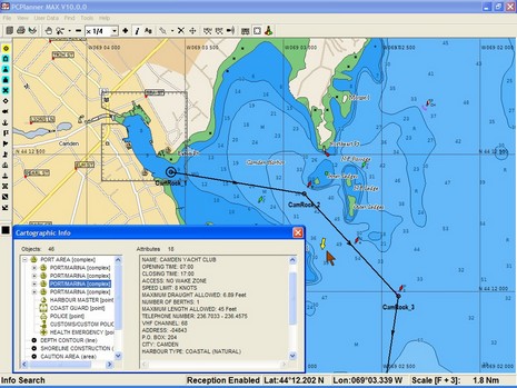
A C-Map question this morning reminded me that I’d meant to comment on my experience with the company’s latest PC Planner product. I’ve always liked the concept: bring home your chart card, stick it in Planner’s reader and use it to do fast, detailed route making on a PC, then bring the routes back to your plotter on a user card. These days Planner is a pretty mature program and also nicely shows off the goodies in C-Map's newish Max chart cards. Check out the streets, detailed harbor info, multi-shaded contours (land too), and even a yellow real time current arrow in the screen shot above (bigger here). The program can also display Max’s perspective view, animated nav lights, and harbor photos. I may have razzed C-Map last spring for its Max marketing, but I like the charts and PC Planner.
And I’ve wondered why Navionics has not yet introduced a similar product. (I have been told it was “about to happen” several times, including quite recently.) Even Garmin users can’t plan on a preprogrammed data card, though they can get the same effect by buying BlueCharts on a CD and making their own card (note that the new G2 charts will not be available on CD, at least at introduction).
At any rate, the question asked this morning was the cost for Malaysian C-Map charts for use on a PC. One reason for the long introduction is that PC charting programs supporting C-Maps can generally read them either from the CD version or from a card via the reader (SOB has a good explanation of the hows and whys here). A "Wide" size CD unlock code for the Malaysian area, either Max or regular NT+, costs about $250 and includes maybe 100 charts (you can drill down to name, scale, etc. detail using C-Map’s online catalog). I’m still working on prices for the applicable cards, which come in two possible sizes for the area; they’re likely a little higher, but can also be used in a dedicated plotter. I was surprised that I couldn’t find these prices online; I think Bluewater usually has such info but their system is down. Any suggestions for other online sources of worldwide electronic charts?
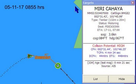
Go to this page to see a series of screen grabs illustrating a scary close call between the 32’ ketch Valhalla and the 132 meter tanker Miri Cahaya. I’d almost guess that the tanker was trying to slow down and turn right to go astern of the ketch, but that’s easy to say sitting in the comfort of my office. Captain Sargent was looking at a whole lot of moving steel with a Closest Point of Approach at one point of 44 meters! He also had prior knowledge of some malicious mariners in these waters, which is probably why he was collecting a history of screen shots. At any rate, he made a possibly controversial last minute decision to turn hard left and cross the tanker’s bow, and it worked. You might also look here to see Valhalla’s AIS setup, which includes a NASA receiver and SOB software (note above how it gives time of last message; nice!). The page also has some screens showing how AIS busy the Malacca Straits are. I understand that the Singapore Vessel Traffic Information System is possibly the busiest in the world, and is using AIS messaging heavily to route ships.
This entry is also an example of how the Internet is changing cruising (and all communications). This incident happened on 11/17, was posted to Valhalla’ssite yesterday, and Panbo reader Steve Tripp emailed me about it today. And as I was writing the entry this morning, Captain Sargent—now located in Langkawi, Malaysia—updated this useful page of cruising info about Port Carmen, Philippines, including an antique chart scan improved with GPS annotations by Steve. Big planet, small world.
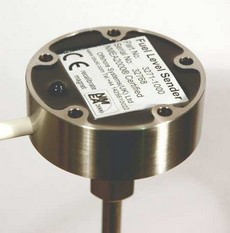
This Offshore Systems fuel sender sounds perfect…stainless steel with no moving parts, measures fuel tank level to 1% accuracy, installs and delivers data all via a NMEA 2000 trunk line, and it can reportedly detect water in the fuel! However, it costs $295 with a 20” probe, more with longer (cutable) probes, and I’m just a tiny bit dubious about the water sensing capability. This sensor is “capacitive”, which I think means it uses the same technology as the “dielectric” bilge pump switches I discussed here once. If the Offshore sender detects water in your fuel it sends alternating “full” and “empty” signals. I wonder if a small amount of water might trigger this, and then you wouldn’t know how much fuel you had? Maybe I’m just being paranoid, but I’d like to hear about successful field trials. Note that Offshore has a new 3125 2000 Sender Adapter which will work with standard resistive senders, and thus with any fluid {corrected 11/28; it turns out that Maretron is not distributing Offshore's sensors (but is working on its own NMEA 2000 tank sender adapter)}.
Update 11/26: I got this note from Offshore Systems: �The water sensing feature really works. Whenever the bottom of the probe detects water the sender sends alternate tank full / tank empty messages at the default rate of 1 message every 2.5 seconds. This will make any display very noticeable to the user to indicate that this tank is contaminated and should not be used until it has been drained and cleaned.� Sounds good�like a little water floating on half a tank of diesel�where it won�t really cause problems�also won�t set off the alarm and stop tank level measuring.
At METS, the U.K. company TackTick—a prior DAME winner for its Micronet wireless instruments—introduced these remote displays. Like the Micronet fixed displays, they’re solar powered and, using a Universal Wireless Interface, can show most any NMEA 0183 data, besides, of course, what’s collected with Micronet sensors. I’m just now realizing how powerful this Interface could be—capable of, say, data networking GPS, PC, another manufacturer’s instruments/sensors, and Micronet. In fact, TackTick even supports proprietary data sentences created on the boat’s PC and then displayed as desired on the Micronet screens (pdf here). It sounds like a savvy sailor or developer could use this to create a very sophisticated instrument system.
Speaking of which, Sailing Anarchy put up a fascinating piece on the super high end sail racing instrumentation that B&G is capable of these days. Note that it is apparently written by a B&G employee, but nonetheless…wow.
Here’s wishing all the Yanks in Panbo world a wonderful Thanksgiving holiday. It’s spitting snow here in Maine, perfect for holing up with friends, family, and a lots of good food. There’s much to give thanks for, but let’s include gizmos too. Needed they’re not, but aren’t they fun?
What really gets me is that when you click on a movie, it starts instantly where you want it to…no fooling with a disk, no previews, no FBI warning. That’s luxurious. Of course it’s cool as hell to have your entire DVD collection organized by cover art, actors, genre, etc. Pick one of those films above and all the other covers will dance around for a moment, then show you the movies most like your pick. The brawn behind all this is the Kaleidescape Entertainment Server with twelve 400 meg hard drives able to hold, and back up, 660 full res DVDs (or 6,000 CDs, and you can chain on more servers as needed). The brains is a reader that hooks via Internet to Kaleidescape’s master database of cover art, categories, and the bookmarks that start the movie just so. Ethernet sends the goods to as many as 25 players around the boat. These babies are becoming quite popular on megayachts. Perfect accessory: a huge Crestron touch screen remote. The whole deal, preferably enjoyed on a sky lounge off the Italian Riviera, almost makes a guy want to be filthy rich.
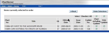
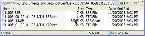
Honestly, I’m a little surprised that NOAA got its RNC ChartServer up and fully populated so soon. (And thanks to GPSNavX for the head’s up). I tried it yesterday, and here’s what I noticed:
* According to the official verbiage, NOAA RNCs (™ yet!) are considered “official” but redistributed copies are not (yet). “At a future date, NOAA intends to establish a program under which distributors may be certified to redistribute NOAA RNCs™ such that they will retain their official status and meet chart carriage regulations.”
* While the underlying charts seem to be the same, and fabulously current (updates applied through 2 weeks ago in many cases), NOAA is using different server software than Maptech’s freeboatingcharts.com. Since each site has unique ways to search for charts, there are now lots of ways to find them. NOAA zips them up for immediate downloading; freeboatingcharts sends you an email when the self-executing zip file is ready.
* Most interesting, I think, is that NOAA is also offering small update files that I presume will make the latest edition of a chart current. This will be great for keeping a portfolio updated, especially for those with narrow-band connections, like on a boat. But I think that the .ptc update file format only works in older Maptech software so far (not, for instance, CNP/CE, yet). Can anyone illuminate me?
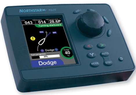
The wise judges of the DAME Design Awards have spoken, and the winner of the marine electronics category is Navman’s G-Pilot 3380. “This is an extremely cohesive product, with an attractive case design, intuitive controls and clear graphic displays on a 3.8in LCD colour screen that include animations, help prompts and a user-friendly compass page.” I’ve raved about this interface before and am pleased to note that it is now also available on the new Northstar 3300 autopilot, with a casing “system matched” to Northstar’s 6000i displays. The two sister companies are a little shy about this duplication, because otherwise their products are quite distinct, but, heck, why not? (Note that I have not tryed the Navman/Northstar pilot on the water, and doubt the judges did either. And even if we had, pilots can perform fine on one boat but not another. All of which is why it’s so hard to introduce a new autopilot.)
The winner of the Marine related software category is Navionics Platinum, which makes sense to me, and relevant Special Mentions include Airmar’s WeatherStation, Simrad’s SART, and something called Octoplex from Moritz Aerospace. I haven’t mentioned the latter yet, but got a good introduction at Lauderdale and agree with the Dame guys about its specialness. More to come.
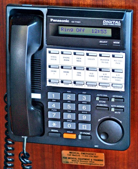
My question, having seen the vast communications closet, was, “Is there a system for least cost routing the yacht’s phone calls?” And the answer was that you just go left to right on the line buttons shown above—shore lines 1 & 2, GSM cellular, Fleet 33, Fleet 77 low and high speed. The first one with a dial tone is the cheapest way to make a call. It’s striking that on these megayachts full of screens and other extravagances, some of the most important install techniques are simple ideas like this, plus excellent labeling.
Also on the “keep it simple (sort of)” theme: this Panasonic Super Hybrid System has apparently become more or less standard on megas, making it easier for installers and crews moving from one boat to another. But the installer did have to take a week-long training in how to set it up (it will even print out bills for charter guests). Note that the cell line is an Ericsson fixed unit, further amplified by a wireless Digital amplifier that also helps out other cells being used near the bridge.


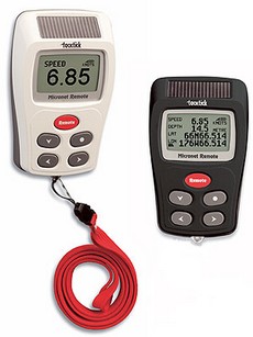 At METS, the U.K. company TackTick—a prior
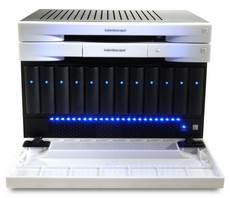 The brawn behind all this is the