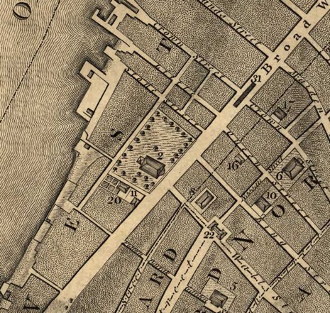
Back in April I noodled about the historical precedents to some of the neat features--like "points of interest" ashore--now coming to electronic charts. I showed a bit of a fabulous 1650 map of New England and promised to one day explain how to get your hands on high resolution scans like these. Today's the day! The source is the Library of Congress (LOC) Map Collection. Here's a link to the full 1767 map of lower Manhattan snipped above, and here's to 1650 New England. You can zoom around the online images but having the full resolution files on your hard drive is, of course, more fun, and they print very nicely. (Shown above, by the way, is the intersection of Broadway and Wall St. with Trinity Church, still there, keyed to a reference list with the "2". Part of my strong interest in this particular area is that the dock upper left on Little Queen St., now Thames St. and 6 blocks inshore from the Hudson, belonged then to Ellisons. Wish the land still did!)
But there is a problem with downloading these images, even assuming a 7.5 meg file is doable with your Internet connection. Some, like these, are in JPEG2000 (.jp2) format and others are in an even more obscure format called MrSID (.sid). Fortunately there's a nice freeware program called Irfanview that will read both formats and convert the images into .jpg or whatever. It's all a bit of trouble, but the maps and charts available from the LOC are fascinating. I dare say that one day some terrabyte plotter or charting program will include them as a sort of historical overlay. And, finally, if you are interested in how Manhattan and America really got started, check out Island at the Center of the World, which also has a Web site that makes use of old cartography.
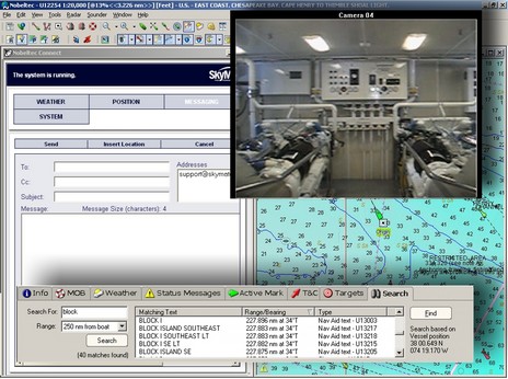
Last night Nobeltec announced the new features coming to VNS and Admiral 8.0 PC navigation software; they’ve been busy! Both packages integrate camera/video displays (for DirectX enabled cameras) and SkyMate communications, plus add a place-name search capability (all illustrated in my collage above, bigger here). Both also now support NOAA ENCs and will plot DSC VHF calls. AIS target tracking has expanded from Admiral to VNS and Nobeltec will be selling the single frequency NASA/Si-Tex AIS100 receiver [corrected 10/16]. Meanwhile, Admiral will now be able to support multiple radars and the InSight Sounder over a GlassBridge Network, resulting in such sexy system possibilities as the one diagrammed below.
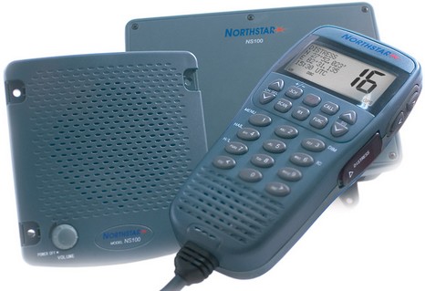
Northstar has just announced two new black box VHF radios—its first communications products ever, I think— and, by gosh, the things actually exist already. The single station NS100 is illustrated above, and there’s also a dual station model with foghorn/hailer/intercom. The radios aren’t even on Northstar’s site yet but I got the single station unit to test in yesterday’s mail. I just had a first look, and, while it is manufactured in China, the fit and finish seem exceptional. I’m told that the design and engineering are entirely Northstar’s, and I look forward to checking it out. I don’t see anything revolutionary in the spec sheet, but I’m hoping to find high performance and a good interface. (I’m also trying a Uniden 525 and two WHAMx4 wireless mics, which should make an interesting comparison. Plus, while I was away, Sitex sent up an eLoran and a black box AIS receiver. I’ve got some shop time ahead getting all this stuff running.)
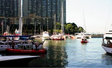
That tall white sport fishing boat, a Luhrs 41, is how I went missing the last few days. My daughter and I took it from lower Manhattan (above) up the Hudson River to Newburgh, N.Y. WiFi, even Internet cafes, were sadly missing, but we had us a fine time exploring our revolutionary era roots. I’m not all that familiar with driving big hp, big prop twin diesels but must say the possibilities are amazing once you get a feel for what just a wee moment in gear can do. Of course it didn’t help to start with an audience of thousands in North Cove. Not to mention the heavy security in these parts, like those heavily armed CG boats above (this is a block from Ground Zero). Plus that’s Ellen MacArthur’s B&Q trimaran moored next to the Luhrs (bigger picture here). She wasn’t around but her program guy Oli was. I tried to talk my way aboard to see the electronics setup but the timing didn’t work out. Oh well, I did get the Luhrs in and out without embarrassment.
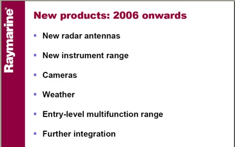
Look what I found while surfing around Raymarine’s investor Web pages. That’s all there is, so here’s some guessing:
* New radar scanners — maybe using Ethernet for fast, flexible connection to the new SeaTalkHS network, and/or able to turn at double or variable speeds for dual ranges or high speed running (like Simrad)?
* New instrument range — might it be SeaTalk2 (NMEA 2000) based like the fine ST290 range, but less expensive?
* Cameras — perhaps relabeled gear from the security industry, but now branded, distributed, and warranted by Ray?
* Weather — is this the “relationship” with The Weather Channel Marine, announced a long time back, now bearing fruit, probably only on the E Series? Via Sirius, with tunes?
* Entry-level multifunction range — hmmm?
* Further integration — AIS receivers, even transponders? Music, etc.? Systems monitoring and switching? Text communications? Web browsing? What?
I’m posting this in the wee hours because I’m off to New York City and a cruise up the Hudson. I’ll be sleeping here tonight. Posting will be spotty for sure until I return next Tuesday.
One comment that inspired my “Geeks vs ME Empire” rant a while back was: “Megalomaniacal marine elex vendors disdain such commoditization as evidenced by the disappearance of most stand alone dumb GPS sensors and proprietary integration of d/s sounders into proprietary networks.” I really, really didn’t understand where that commenter was coming from. It strikes me that the planet is awash in GPS sensors that can output in NMEA 0183 format (or 2000) via bare wire, standard serial plug, USB, Bluetooth, etc. etc. I have a cheap Deluo mouse GPS that has swappable dongles so that it can output via DB9, USB, and custom iPaq PDA serial plugs (& get power too), and it’s worked with all sorts of software. How commoditized can you get?
And while it wasn’t long ago that all depth, speed, temp, etc. sensors were proprietary, these days Airmar (which makes most of them) offers a wide variety of “Smart” versions. More than I realized, actually, as I discovered at Airmar’s much improved web site (try the Smart Sensor .pdf for starters). As illustrated, these sensors process their own signals. Add power and out comes NMEA 0183 or 2000 data to feed a plotter or multifunction display from most any of the ME manufacturers or a PC or, in the 2000 case, a network of up to 50 separate devices. So what was that guy talking about?
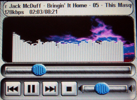
The music screen above is from a Lowrance iWay automobile mapping system. It has a touchscreen and a 20 gig hard drive—partitioned so that 10 gigs are for onboard maps, 10 for tunes. PC Magazine made the iWay its Editor’s Choice in a May roundup review that included units from Garmin, Magellan, and Navman. I just came across it and was reminded of how Darrell Lowrance enthused about touch screens for multifunction marine displays during a press conference at the Miami Boat Show last winter. Lowrance’s best 2005 plotter/fishfinders are already similar to the iWay series in many aspects, like the hard drive; will they get touchscreens and MP3 players next year? There’s a ferocious competition going on to be a dominant player in the car plotter market, which has got to explode at some point. What are the manufacturers learning and developing that might migrate to boats?
I hesitate to report RUMORS, but given that strong caveat, these seem worth a “head’s up”: supposedly Lowrance’s NMEA 2000 GPS sensors have trouble with radar transmissions, and supposedly its NauticPath marine charts don’t properly show obstructions that are awash between high and low tide. Mind you, these are only rumors and, even if true, may have been fixed already or are about to be.
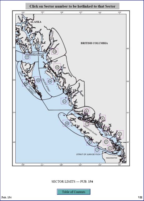
I learned about SeaRef the hard way, when its developer Dan Podell tried to advertise it by posting messages on the PMY forums. That’s a no-no there, and here too, but I did contact Dan to tell him that I’d be happy to have a look at his CD full of nautical info. I’m doing that right now, and am impressed. SeaRef is a well organized compendium of useful calculators, tables, and publications. The example above is a page from a hyperlinked .pdf version of the BC Sailing Directions. You can learn more about the CD’s contents, or buy it, at Podell’s eBay site.
You may realize that most, maybe all, of SeaRef’s contents can be downloaded for free from various web sites, but I’d say that Podell is charging a very reasonable fee for finding it all and organizing it with .html pages. You may also realize that the SetSail.com Navigator’s Library is a similar product. I tried an earlier edition of that product and note that it now comes on 2 CD’s and contains a number of items missing from SeaRef, like the complete Bowditch, the CIA World Factbook, and numerous Sailing Directions for areas outside North America. On the other hand, it’s more expensive and at least the edition I tried had a fairly obnoxious copy protection scheme. SeaRef is unprotected and has items NL doesn’t, like a Medical Handbook (oriented to ships, like much of this material, though still useful), flags of the world, and much more.
PS If you have a marine electronics/navigation product you want me to know about or try, please just e-mail me ([email protected]).
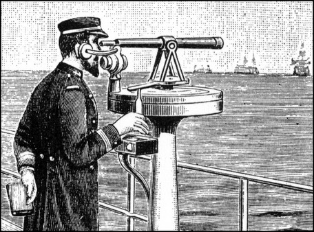
I was just looking for compass stuff in some nautical clip art I have (we used it a lot when I edited Reed’s). I came across this image and must say I don’t know for sure what this fellow is up to. I see what seem to be a telescope on what may be a pelorus, an earphone, a microphone, a booklet, and maybe a control box with cables or tubing headed off somewhere. What is this gent doing?
The compass adjustment trip that I missed the other day was aboard a nearly brand new, high quality 30’ power boat. But the steering compass, a decent Ritchie SS1000, turned out to be 45° off on some headings and “limp” if you were pointed north! Jeff Kaufmann tells me that this is just an extreme example of a common situation. Boatbuilders may install the compass but don’t pay attention to the deviation, leaving that for whoever installs all the electronics, who may not pay attention either. Jeff says his fee is sometimes paid by a yacht broker trying to complete a deal, because no one else will take responsibility.
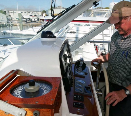
At any rate, Jeff took this boat out into Penobscot Bay and used a GPS bearing to a fixed and charted object to get one solid bearing. With that reference he could then use his directional gyro (lower left in the Bloomquist photo above, home built from old military parts) to check the compass on multiple headings. Then he used that little magnetometer in his hand to look for the culprits. The main problem turned out to be a large steel hydraulic steering control mounted almost directly under the compass (the yacht in the picture is not the same boat, by the way).
Using well developed intuition plus trial and error, he figured out where to position an external magnet to negate the offending one. That took a big bite out the worst deviations, plus made the compass lively again on North headings. Then he used the SS1000’s small built-in correction magnets to get the deviation nearly to zero on all headings. Finally, he checked for possible transient problems and found one in the windshield wiper motor, which he couldn’t fix, of course, but did note on the deviation card. Jeff has come across a lot of odd compass problems over the years; I think at this point he can look around a boat and visualize 3D magnetic fields emanating from wiper motors, power cables, buzzers, hunks of steel, CRT tubes, etc. etc.
Ritchie, incidentally, has a good guide to compass basics that they will send you for free or let you download as a .pdf.


 n NMEA 0183 format (or 2000) via bare wire, standard serial plug, USB, Bluetooth, etc. etc. I have a cheap